

17:35: High tide in Cua Lo
In Cua Lo ward, Nghe An province, after about an hour of calm, the wind has now returned, blowing continuously. It is raining heavily, many trees and billboards have been knocked down. The high tide has caused flooding on many roads.
17:30: Waves higher than 3m at Hon La port
Located on the border with Ha Tinh , Hon La port, Phu Trach commune, Quang Tri province was heavily affected by storm No. 5. Waves higher than 3 meters hit the shore, flooded the road to the port, and the entire area lost power.
17:25: Deputy Prime Minister requests to ensure smooth communication
Working with the Forward Command of Military Region 4 in Nghe An province, Deputy Prime Minister Tran Hong Ha asked telecommunications agencies to prepare plans to ensure uninterrupted communication to villages, hamlets, and residential areas. "Organizations and units must give top priority to the safety, reliability, and speed of the network, especially in mountainous, remote, and easily isolated areas," said the Deputy Prime Minister.

The Government leader also noted the addition of a plan to support information equipment for the Border Guard to maintain information in all situations. According to Lieutenant Colonel Luu Manh Ha, General Director of Viettel Networks Military Industry and Telecommunications Group, before the storm, the group inspected and reinforced the cable system and lowered the height of antenna towers. More than 1,200 personnel and mobile station vehicles were reinforced for Nghe An, Ha Tinh, and Thanh Hoa, along with backup generators at key stations.

Viettel also deployed a new generation satellite modem to replace damaged ground infrastructure, to restore emergency communications, and to serve storm response and recovery.
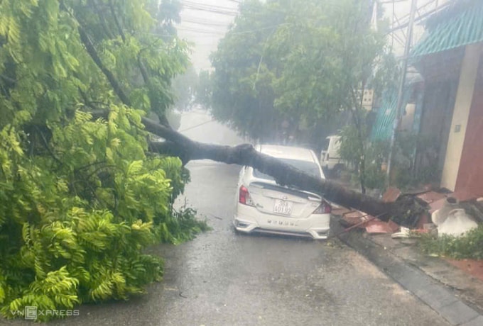
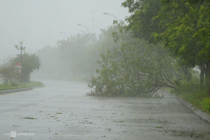
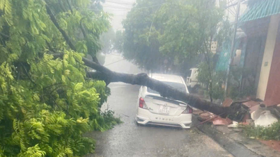
17:20: Fallen tree crushes car in Thanh Hoa
In Hac Thanh ward, Thanh Hoa city and Sam Son ward, a series of trees fell, crushing cars and blocking the road. Due to heavy rain, the authorities banned people from going out, so the scene was still chaotic.

16:45: Ha Tinh evacuated 4,000 more people
Storm No. 5 raged, causing heavy rain and strong winds in Vung Ang ward, formerly part of the old Ky Anh town. The authorities have evacuated more than 1,000 households with about 4,000 people to safety. "From early afternoon, we issued an evacuation order, mobilized all forces, and gave absolute priority to the safety of the people," said Mr. Tran Xuan Phuong, Secretary of the Party Committee of Vung Ang ward.

In Co Dam commune, in the old Nghi Xuan district, bordering Cua Lo ward, Nghe An province, the high tide is close to the foot of the sea dike but no damage has been recorded. The local police, army and militia are on duty to promptly handle the incident.
16:45: The storm caused level 9 winds, gusts of level 11 in Nghe An.
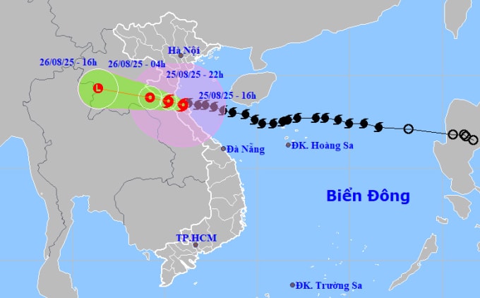
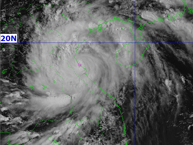
The National Center for Hydro-Meteorological Forecasting said that in the past 3 hours, the storm has barely moved, its intensity has decreased to level 12, gusting to level 14. It is forecasted that in the next 3-6 hours, the storm will move in a west-northwest direction, entering northern Ha Tinh - southern Nghe An. At 4 p.m., the storm center will be on the coastal waters of Nghe An - Ha Tinh, with the strongest wind speed of 133 km/h, level 12, gusting to level 14. It is forecasted that by 10 p.m., the storm will be on land in Thanh Hoa - Ha Tinh, with the strongest wind speed of level 8 - 9, gusting to level 11, then weaken into a tropical depression in Central Laos.
The meteorological agency measured strong winds of level 9, gusting to level 11 in Dien Chau (Nghe An); Quynh Luu level 7, gusting to level 10; Hon Ngu (Nghe An) level 8, gusting to level 11; Hoanh Son (Ha Tinh) level 7, gusting to level 9; Ky Anh (Ha Tinh) level 8, gusting to level 11; Cam Nhuong level 9, gusting to level 12. Storm surge in Sam Son (Thanh Hoa) was one meter, Hon Ngu (Nghe An) 1.66 m, Vung Ang (Ha Tinh) 0.51 m. In the Northern Delta provinces, Thanh Hoa - Quang Tri had over 500 mm of rain.
15:40: Waves 3 - 4 m high hit Sam Son beach
15:35: Ha Tinh has very heavy rain, many areas have power outages
The coastal area of Ha Tinh was in torrential rain, visibility was only under 20 meters. Half an hour ago, the wind blew in from the sea, but now each gust of wind blew back from the shore to the sea. Trees were swaying, falling down in the wind. At Thien Cam beach resort, inside the high-rise buildings, the wind shook the closed doors. Outside, there was the sound of wind whistling, the sound of corrugated iron roofs hitting each other. The area had lost power, and the phone signal was unstable. Most people had gone to shelters.
15:30: Beware of the calm in the storm
Recorded at the center of the storm in Nghe An, in the past 30 minutes the wind has been calm, some areas have stopped raining, and the damage is not significant. Mr. Nguyen Van Huong, Head of the Weather Forecast Department, National Center for Hydro-Meteorological Forecasting, explained that the center of the storm has not completely reached the mainland, 2/3 is still at sea. In the next 1-2 hours, the center of the storm will be completely inland. "The center of the storm is moving towards the shore, so there will be a period of calm before the wind becomes strong again. At this time, the wind can be as strong as or even stronger than before the storm hit the shore," said Mr. Huong. Tonight, from southern Nghe An to Ha Tinh, there will be strong storm winds of level 11-12; Thanh Hoa, Quang Tri will have strong storm winds of level 8-9, gusting to level 10-12.

According to the meteorological agency, the water level on the Thao River (Lao Cai), rivers in Ha Tinh, and northern Quang Tri is rising. At 1 p.m. on August 25, the water level on the Gianh River (Quang Tri) at Dong Tam station rose to 7.74 m, 0.74 m above alert level one. It is forecasted that from now until August 28, floods will occur on the Thao River (Lao Cai), and rivers in Thanh Hoa - Quang Tri. The flood peak on small rivers, upstream of the Ca River (Nghe An), Ngan Sau River, Ngan Pho River (Ha Tinh), and Gianh River (Quang Tri) will rise to alert levels two and three; Buoi River, upper Ma River (Thanh Hoa), Kien Giang River, Thach Han River (Quang Tri) are at alert level one, two and above alert level two; Thao River, lower Ca River (Nghe An), La River (Ha Tinh) are at alert level one. Low-lying areas along rivers, urban areas, and densely populated areas are at risk of flooding; steep slopes in mountainous areas of Lao Cai, Phu Tho provinces and the Thanh Hoa - Quang Tri region may experience flash floods and landslides.
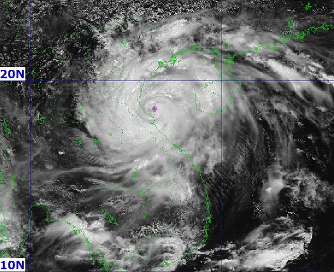
15:15: Storm hits Nghe An - Ha Tinh
The National Center for Hydro-Meteorological Forecasting said the storm's center is on the coast of Nghe An - Ha Tinh, with the strongest wind speed of 133 km/h, level 12, gusting to 14-15. In the next three hours, the storm will head west, at a speed of about 10-15 km/h.
15:10: Many fish cages at sea were hit by waves
Not in the eye of the storm, but in Phu Trach commune, Quang Tri province, the wind was howling, the waves were 2 meters high. Looking at 6 fish cages at sea being washed ashore by the waves, Mr. Cao Thai, Phu Trach commune said: "There is no one on the raft, observing through the camera that many cages were damaged by the waves, it is very heartbreaking".
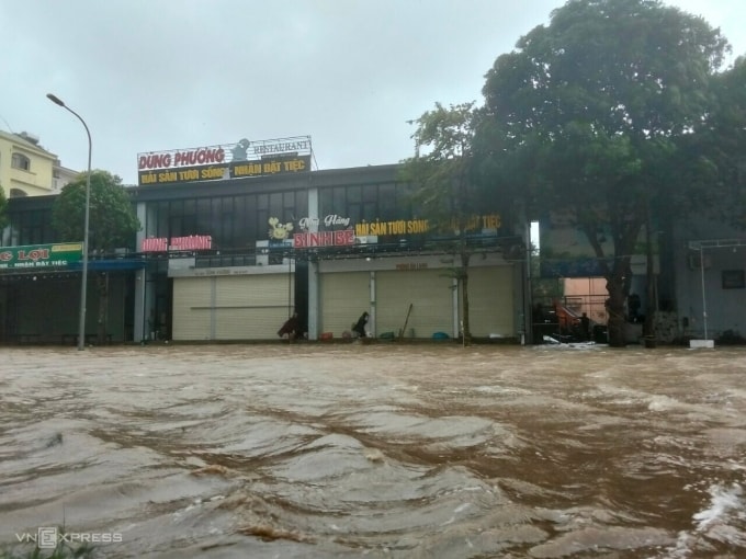
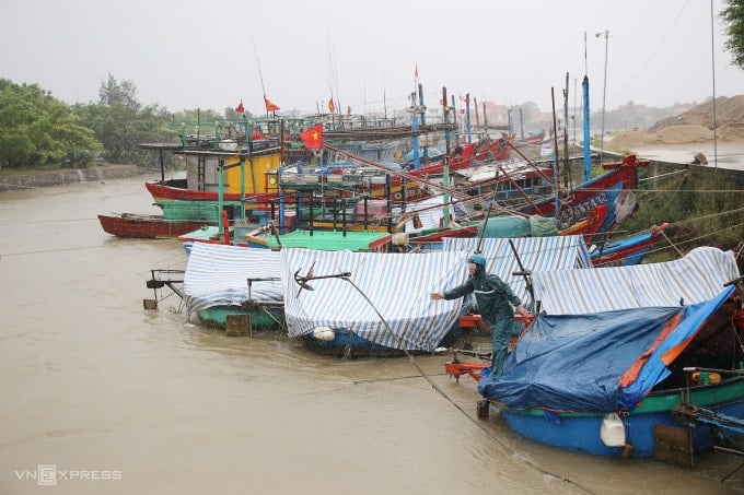
15:05 Cua Lo is in chaos in the storm
Several high-voltage lamp posts and trees on the streets of Cua Lo Ward were broken. Authorities predict that when the storm hits, the damage to trees and infrastructure may be more severe.

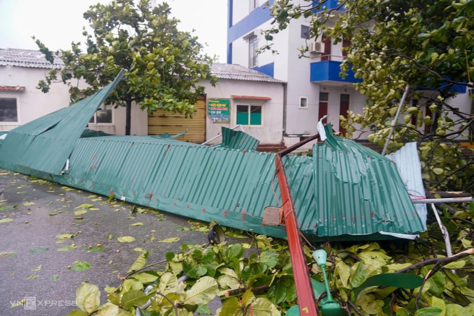
15:00: Storm rips off the roof of hotel and kiosk on Thien Cam beach, Ha Tinh

14:40: Nearly 400 communes at risk of landslides and flash floods
The National Center for Hydro-Meteorological Forecasting said that from 0:00 to 13:00 today, at Song Rac Lake, it rained 360 mm, Ky Lam 373 mm (Ha Tinh); Song Thai Lake 310 mm, Be Lake 288 mm (Quang Tri). Currently, the soil moisture model shows that some areas are nearly saturated or have reached saturation.
In the next 3-6 hours, Phu Tho, Quang Ninh, Quang Tri are forecast to have 30-70 mm of rain, some places over 100 mm; Thanh Hoa, Nghe An and Ha Tinh will have 70-120 mm of rain, some places over 200 mm, so the meteorological agency warns of the risk of landslides and flash floods in 398 communes. Of which, the communes at very high risk include: Ngoc Lien, Kien Tho, Minh Son, Thach Quang, Xuan Tin, Van Xuan, Luong Son, Luan Thanh, Thang Loc, Thuong Xuan, Xuan Chinh, Tan Thanh, Nhu Xuan, Xuan Binh, Hoa Quy, Thanh Phong, Thanh Quan, Thuong Ninh, Nhu Thanh, Mau Lam, Xuan Thai, Yen Tho, Thanh Ky of Thanh Hoa province.
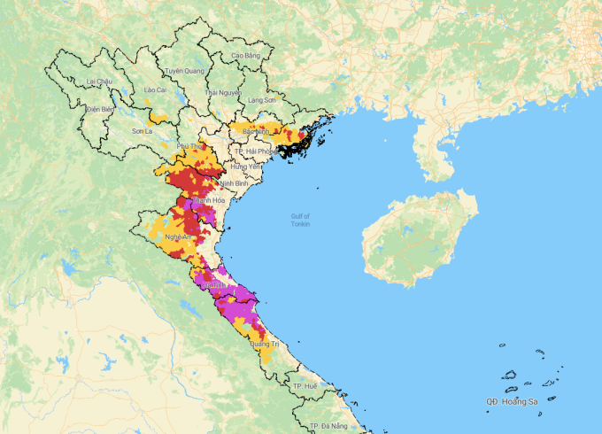
In Nghe An, there are Thong Thu, Tien Phong, Quy Chau, Nghia Hung, Quy Hop, Tam Hop, Tan Ky, Xuan Lam, Kim Bang, Bich Hao, Van An. In Ha Tinh, there are Bac Hong Linh, Nam Hong Linh, Huong Son, Son Tien, Son Tay, Son Kim 2, Tu My, Duc Tho, Duc Minh, Duc Quang, Duc Dong, Vu Quang, Mai Hoa, Thuong Duc, Nghi Xuan, Co Dam, Can Loc, Hong Loc, Tung Loc, Truong Luu, Huong Khe, Ha Linh, Huong Binh, Huong Pho, Huong Xuan, Phuc Trach, Huong Do, Mai Phu, Thach Khe, Thach Xuan, Cam Xuyen, Cam Hung, Cam Due, Cam Trung, Cam Lach, Song Tri, Ky Xuan, Ky Anh, Hai Ninh, Ky Van, Ky Khang, Ky Hoa, Vung Ang, Hoanh Son, Ky Lac, Ky Thuong. In Quang Tri, there are Minh Hoa, Dan Hoa, Tan Thanh, Kim Dien, Kim Phu, Dong Le, Tuyen Son, Tuyen Lam, Tuyen Phu, Tuyen Binh, Tuyen Hoa, Phu Trach, Trung Thuan, Hoa Trach, Tan Gianh, Quang. Trach, Ba Don, Nam Gianh, Hoan Lao, Bac Trach, Phong Nha, Bo Trach, Dong Trach, Nam Trach, Quang Ninh.
14:35: Prime Minister requests urgent evacuation of people in dangerous areas
Prime Minister Pham Minh Chinh has just issued a telegram requesting the provinces of Thanh Hoa, Nghe An, Ha Tinh, Quang Tri, Hung Yen, Ninh Binh and localities to forecast the risk of prolonged heavy rains and evacuate people in areas at risk of flash floods, landslides. The provinces need to resolutely evacuate people in dangerous areas, on boats at anchorages, rafts, and aquaculture watchtowers; limit people and vehicles on roads and rivers, and strictly control people's travel during strong storms.
Localities inspect response work in communes, villages and hamlets at risk of being isolated, focusing on evacuating residents from dangerous areas, ensuring food and essential supplies, electricity and uninterrupted communication; directing the safe operation of hydroelectric and irrigation dams. The Ministries of National Defense and Public Security direct the deployment of forces and vehicles, including helicopters, in key areas to support the relocation and evacuation of residents and be ready for rescue when required. The Minister of Construction directs the work of ensuring safety for people, vehicles and safety for road, rail, waterway and air traffic activities.
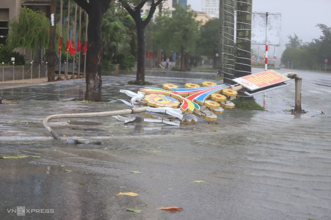
14:25: Waves hit Sam Son seawall 2m high
At Sam Son beach, waves crashed into the 2-meter-high embankment, creating murky foam. People followed the provincial chairman's instructions to stay out of the streets and keep their doors closed.
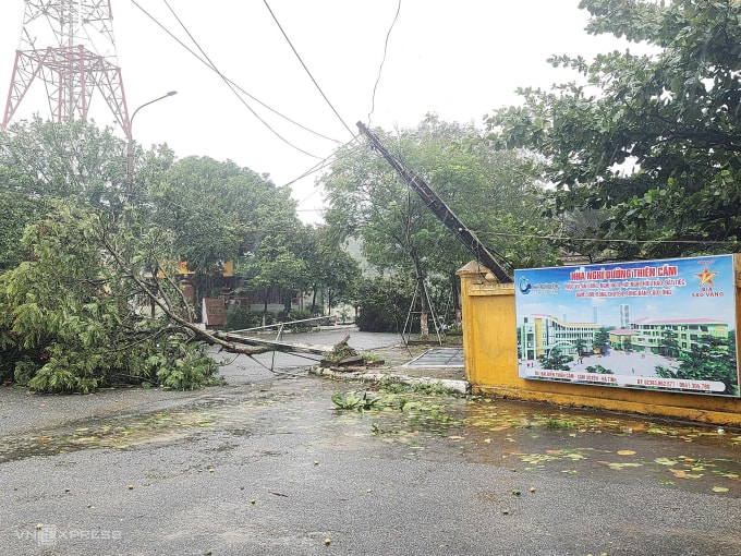
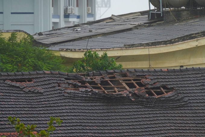
14:20: Ha Tinh coastal area, many trees fell
On the streets in the Thien Cam beach area, Ha Tinh, trees fell in large numbers, causing some electric poles to tilt.

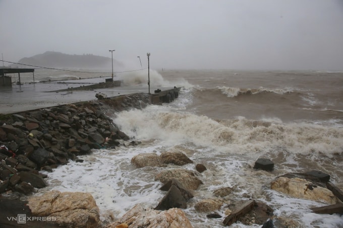
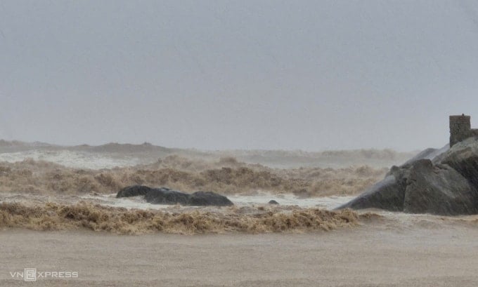
14:10: Waves 2 - 3 m high hit the coast of Ha Tinh
At Thien Cam beach resort, Thien Cam commune, Ha Tinh province, the wind howled continuously and the rain poured down from the morning to the afternoon of August 25 with no signs of stopping. Waves 2-3 meters high continuously crashed into Thien Cam beach. The wind tore off the corrugated iron roof and ripped open the doors, even though the residents and owners of the motel and hotel had proactively tied down the oars beforehand.
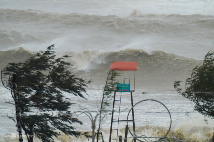
White-capped waves continuously hit Thien Cam beach at 2:00 p.m. on August 25. Photo: Nguyen Dong.
On the coastal dike, many shops and some low-rise houses had their corrugated iron and tile roofs blown away by the wind. The Union Hotel on the outskirts of the province was torn apart by the wind, with hundreds of meters of corrugated iron roof thrown to the ground. People strictly followed the order not to leave their homes. Local authorities arranged solid houses and requisitioned hotels belonging to provincial units for people in low-rise houses to take shelter.
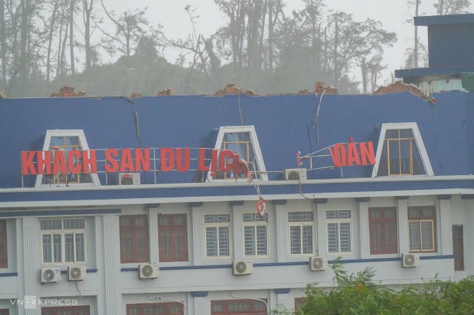
The corrugated iron roof of the Trade Union Guesthouse of Ha Tinh Provincial Trade Union and the tiled roof of Thien Cam Resort, belonging to Ha Tinh Provincial Police, were damaged by the storm. Photo: Nguyen Dong.
13:55: The wind started to gust.
Two hours before the storm made landfall along the Thanh Hoa - Nghe An coast, strong winds began to blow in Nam Sam Son ward, Thanh Hoa province. This area is more than 300 meters from the sea. Tourism was temporarily suspended, shops were closed, and the roads were deserted. Some residential groups in Nam Sam Son lost power. The family of Ms. Du Thi Hang in Hong Ha residential group had stocked up enough food for two days to limit going out. Yesterday, the family reinforced the corrugated iron roof, moved the potted plants on the balcony inside, and told their children not to go out when the storm made landfall.
13:40: Storm downgraded one level, but still very strong
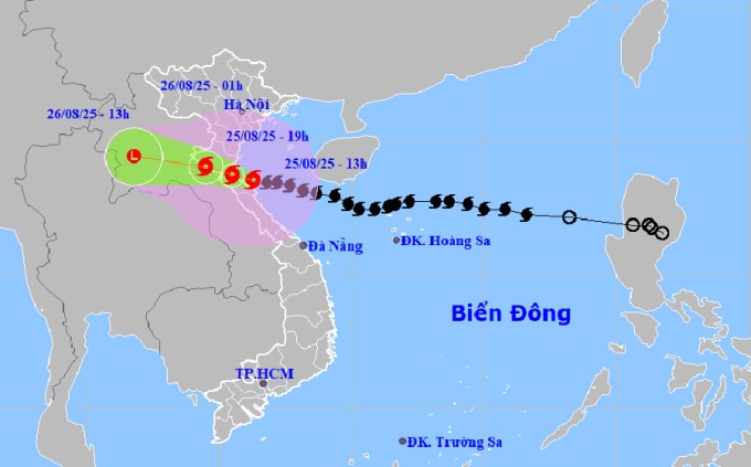
According to the National Center for Hydro-Meteorological Forecasting, at 1:00 p.m. on August 25, the storm's center was in the coastal waters of Nghe An - Ha Tinh, with winds of 149 km/h, level 13, gusting to level 16, down one level from two hours ago. It is forecasted that in the next three hours, the storm will move west-northwest at a speed of about 15 km/h, making landfall in Nghe An - Ha Tinh.
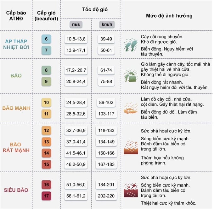
According to the typhoon scale, a level 13 storm with maximum winds of 149 km/h is very strong, equivalent to Yagi making landfall in Quang Ninh and Hai Phong in September 2024. The storm's winds can blow away trees, completely destroy fragile structures, and cause severe damage even to large buildings. Small ships, if not anchored carefully, can be broken and sunk at ports and docks.
Mr. Mai Van Khiem, Director of the National Center for Hydro-Meteorological Forecasting, said that in the past two hours, the storm moved at a speed of 10-15 km/h, a little slower than in the early morning. Through analysis of satellite cloud images and meteorological radar, it is shown that storm Kajiki is starting to show signs of weakening, and may decrease to 13 km/h in the next 1-2 hours.
According to Mr. Khiem, the storm will make landfall, with the focus being on the north of Ha Tinh - Nghe An at around 3-4pm. This is also the time when the wind is strong at level 12, gusting to level 14-15 with a radius of 50km around the storm's center. Therefore, the areas of northern Ha Tinh, Nghe An and southern Thanh Hoa will be extremely dangerous due to the wind, with the natural disaster risk level at level 4 on the 5-level scale.
"According to the direction of movement, the storm's southern part will have a weaker impact than the northern part, so strong winds in Hue and Quang Tri will gradually decrease," Mr. Khiem added.

The most dangerous current risk is flash floods and landslides. The reason is that the storm has not yet arrived but the rain from last night until now has been very heavy. When it was in the south of Hainan Island (China), the storm caused more than 400 mm of rain in 24 hours. Currently, the storm's circulation yesterday and today is not much different, so the possibility of rain today will also be very heavy.
Mr. Khiem assessed that with other storms, the rain might only be concentrated on the coast, but this storm will cause rain in all areas from the coast, plains to the western mountains of Thanh Hoa, Nghe An, Ha Tinh and even expand to southern Phu Tho and Lao Cai.
"Even if the storm weakens in Laos, the risk of landslides and flash floods still needs to be guarded against in the next 2-3 days because Central and Upper Laos will have heavy rain and floods from some rivers with upstream flows from here to Vietnam," said Mr. Khiem.
12:30: Nghe An continues to evacuate people
In coastal communes of Nghe An, from morning to noon today, the authorities continued to evacuate people to avoid storm Kajiki. In coastal commune of Quynh Phu, authorities organized the evacuation of 1,705 people from dangerous areas, settling them in solid houses to ensure safety of life and property. The authorities mobilized forces to support each household in moving, minimizing risks when the storm makes landfall.
In Cua Lo ward, which is expected to be directly affected by Typhoon Kajiki, more than 2,500 people from 380 households have been taken to schools, hotels and high-rise buildings. The forces have checked each family, absolutely not allowing people to stay at sea or in cages. "Being taken to a safe place by the officers and militia, I feel secure and very grateful to the government for taking care of the people," said Ms. Hoang Thi Hanh, 90 years old.
Thanh Vinh and Truong Vinh wards also urgently evacuated thousands of households in old apartment buildings, collective housing areas and vulnerable areas. By noon of the same day, all residents in danger had been moved to concentrated shelters, ensuring temporary living conditions.


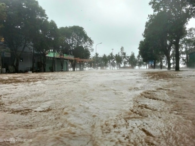
12:20 pm: Many roads in central wards of Nghe An are deeply flooded
In Thanh Vinh ward, Nghe An province, strong winds and heavy rain lasting 20-30 minutes caused many roads to be partially flooded. On Nguyen Truong To and Nguyen Thai Hoc streets, water rose 30-40 cm, causing traffic congestion and difficulty for vehicles to move.
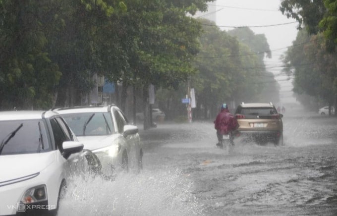
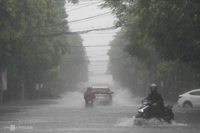
Some trees along the roads such as Nguyen Thai Hoc, Truong Chinh and Lam River were uprooted, broken, blocking the way. Authorities are urgently handling the situation to clear the road.
12:10 pm: Quang Tri fishermen anchor their boats in the rain
Although not in the eye of the storm, the northern part of Quang Tri province, bordering Ha Tinh, has been raining heavily since noon today. On the Roon River, Hoa Trach Commune, heavy rains have forced upstream water to flow strongly, many fishermen braved the rain to bring ropes to reinforce their boats.
The southwest wind was gusting and it was raining heavily, but Mr. Tran Tuan, whose boat was anchored by the river, still reinforced it and tied ropes to avoid being swept away. A few days ago, when he heard the storm was coming, he had anchored the boat at Canh Duong bridge, but the water was flowing strongly so he was still cautious.
Quang Tri Province has advised people to stay off the streets since last night to ensure safety. The province has 8,725 boats with 24,198 workers, of which 8,711 fishing boats with more than 24,100 workers are anchored to avoid the storm. Currently, there are only 14 fishing boats with 72 workers operating in the southern sea, including 10 boats (42 workers) in Quang Ngai and 4 boats (30 workers) in the Lam Dong - Ca Mau area.
12:00: Road closures may occur during storms.
The Traffic Police Department on the afternoon of August 25 advised vehicles to limit their movement on National Highway 1 and the North-South Expressway passing through Nghe An and Ha Tinh provinces; if necessary, road closures will be organized, and vehicles will proactively find suitable routes.
Previously, from 6:00 a.m., Cua Hoi bridge across Lam river connecting Nghe An and Ha Tinh provinces was closed to vehicles, and authorities assigned people to organize warnings and traffic flow from a distance.
11:45: Thanh Hoa continues to evacuate people
Directly affected by the storm, Thanh Hoa has evacuated nearly 2,000 households in coastal areas, where the risk of landslides is high. However, this afternoon the storm is likely to shift, causing risks of flooding and damage to houses.
11:25: Sam Son strong waves combined with high tide
The tourist sea area of Thanh Hoa is raining heavily. The turbid waves are 1-2 meters high and crash into the shore. "The waves gradually increase and can reach their peak when the storm comes at the same time as the high tide," fisherman Tran Van Huu, 70 years old, said.
Source: https://baohaiphong.vn/bao-so-5-da-do-bo-vao-nghe-an-ha-tinh-519070.html
![[Photo] General Secretary To Lam attends the 80th anniversary of Vietnam's diplomacy](https://vphoto.vietnam.vn/thumb/1200x675/vietnam/resource/IMAGE/2025/8/25/3dc715efdbf74937b6fe8072bac5cb30)


Comment (0)