
Without the support of modern technology, ancient mapmakers needed a great deal of time to create maps and had to synthesize information from many different sources.
Anaximander's "known world " map. Image: Wikimedia
Ancient mapmakers relied on a combination of art, exploration, mathematics, and imagination to capture the vastness of the lands they knew and many that they believed existed. In many cases, these early maps both aided navigation and revealed mystical wonders.
Creating maps required a great deal of time from ancient times. Maps are the result of generations of travelers, explorers, geographers, cartographers, mathematicians, historians, and other scholars piecing together fragmented pieces of information. Therefore, early works relied on some actual measurements, but also on much speculation.
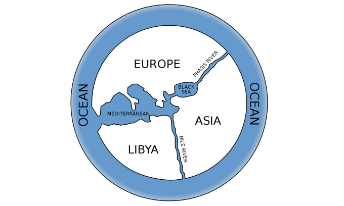
One of the earliest detailed descriptions of the "known world" was created by Anaximander, a philosopher who lived approximately 610–546 BC and is considered one of the seven Sages of Greece. The phrase "known world" is emphasized because Anaximander's circular map shows the landmass of Greece (at the center of the world) and parts of Europe, South Asia, and North Africa. For the Sage, these continents fit together into a circle surrounded by water. The Earth was then considered flat.
In the 1st century BC, Eratosthenes of Cyrene, a Greek scholar, calculated the circumference of the blue planet by comparing survey results collected in the Library of Alexandria. Although many previously believed the Earth was round, modern scientists have no recorded evidence of how they measured the Earth's circumference. But Eratosthenes' case is an exception.
Eratosthenes' method was simple and anyone could do it today. He measured the length of the shadow cast by a vertical stick in two cities on the same day. Then, the north-south distance between the two cities and the measured angles provided a ratio that allowed him to calculate the Earth's circumference with relative accuracy (approximately 40,000 km). After Eratosthenes published his results, maps of the flat Earth continued to circulate for a time but eventually disappeared.
Eratosthenes also developed a method for locating places more precisely. He used a grid system—similar to the system on modern maps—that divided the world into sections. This grid system allowed people to estimate their distance from any recorded location. He also divided the known world into five climatic zones—two temperate zones, two polar zones in the north and south, and a tropical zone around the equator. These made for a much more complex map, depicting the world in greater detail.
In the following centuries, maps became more complex as Roman and Greek cartographers continued to gather information from travelers and armies. Synthesizing this material, the scholar Claudius Ptolemy wrote the famous book *Geographia*, and maps were based on it.
Ptolemy's work, compiled around 150 AD, relies heavily on older sources. However, what made Ptolemy so influential was his clear explanation of how he created his work, allowing others to replicate his techniques. The Geographia contained detailed coordinates of every location he knew (over 8,000 locations). Ptolemy also introduced the concept of latitude and longitude, which are still used today.
Geographia was introduced to Europe in the 15th century. For many years, Islamic scholars examined, scrutinized, and even revised Ptolemy's work. His work, along with new maps by influential geographers such as Muhammad al-Idrisi, became extremely popular with explorers and cartographers in the Netherlands, Italy, and France by the mid-18th century.
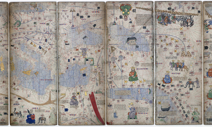
A section of the Catalan Atlas. Photo: Wikimedia
A significant development in mapping was the invention of the magnetic compass. While knowledge of magnetism had existed for a long time, its application to reliable navigational devices only began around the 13th century. The compass rendered many older maps obsolete for navigation. This was followed by the invention of the portolan, a nautical guide used for navigating between ports.
A prominent example of a Portolan map is the Catalan Atlas, created by cartographers for King Charles V of France. They created the map by synthesizing information from various sources. The exact authorship remains unclear, but many experts believe the map was created by Abraham Cresques and his son, Jahuda.
The Catalan Atlas is full of information about real places, but it also contains many fantastical details. This problem arises from compiling maps from many different sources, including traveler's stories and mythology. As a result, beasts, dragons, sea monsters, and fictional lands continued to appear on many maps for a long time afterward.
Thu Thao (According to IFL Science )
Source link


![[Photo] Prime Minister Pham Minh Chinh attends the Conference on the Implementation of Tasks for 2026 of the Industry and Trade Sector](/_next/image?url=https%3A%2F%2Fvphoto.vietnam.vn%2Fthumb%2F1200x675%2Fvietnam%2Fresource%2FIMAGE%2F2025%2F12%2F19%2F1766159500458_ndo_br_shared31-jpg.webp&w=3840&q=75)


![[INFOGRAPHIC] Legion Go Gen 2 sets a new standard for gaming.](https://vphoto.vietnam.vn/thumb/402x226/vietnam/resource/IMAGE/2025/12/19/1766146888809_info-taycamgames-02-jpg.webp)


Comment (0)