

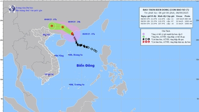
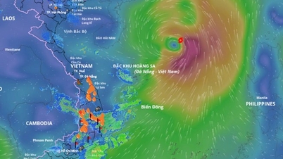
Updated at 6am on the location of the tropical depression that is likely to strengthen into storm No. 7. Source: Vietnam Disaster Monitoring System
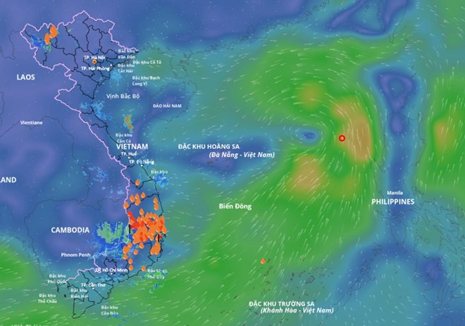
According to the National Center for Hydro-Meteorological Forecasting, at 1:00 a.m. on September 6, the center of the tropical depression was located at about 17.4 degrees north latitude - 118.3 degrees east longitude, in the sea east of the northern East Sea. The strongest wind near the center of the tropical depression was level 6 (39-49 km/h), gusting to level 8. The tropical depression moved northwest at a speed of about 10 km/h.
It is forecasted that in the next 24 hours, the tropical depression will move northwest at a speed of about 10km/h and is likely to strengthen into a storm.
At 1:00 a.m. on September 7, the center of the storm was at approximately 18.7 degrees north latitude - 116.3 degrees east longitude, approximately 500km east-northeast of Hoang Sa special zone. Wind force level 8, gust level 10.
The danger zone is within the latitude range of 16 - 20 degrees north and longitude range of 114.5 - 120 degrees east. The disaster risk level is level 3, affecting the eastern sea area of the northern East Sea.
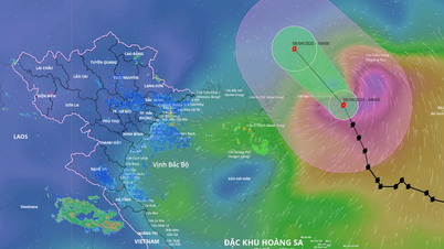
Forecast in the next 48 hours, the storm moves northwest at a speed of about 15km/h, continuing to strengthen.
At 1:00 a.m. on September 8, the center of the storm was located at approximately 20.9 degrees north latitude - 113.8 degrees east longitude, in the northern waters of the northern East Sea. Wind force level 9, gust level 11.
The danger zone is within the latitude range of 17 - 22 degrees north and longitude range of 112 - 118 degrees east. The disaster risk level is level 3, affecting the northern sea area of the North East Sea.
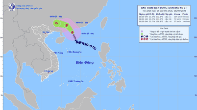
Forecast in the next 48 - 72 hours , the storm moves west-northwest, about 15km per hour.
Regarding the impact of tropical depression/storm, at sea, the sea area east of the northern East Sea has strong winds of level 6, later increasing to level 7 - 8, gusting to level 10; waves 2 - 4m high, rough seas. Ships operating in the above dangerous areas are likely to be affected by storms, whirlwinds, strong winds, and large waves.
Laodong.vn
Source: https://laodong.vn/moi-truong/du-bao-kha-nang-sap-don-bao-so-7-trong-24-gio-toi-1569665.ldo


![[Photo] Impressive display booths of provinces and cities at the Exhibition 80 years of the Journey of Independence - Freedom - Happiness](https://vphoto.vietnam.vn/thumb/1200x675/vietnam/resource/IMAGE/2025/9/7/cd63e24d8ef7414dbf2194ab1af337ed)


![[Highlight] VIMC's mark at the National Achievement Exhibition](https://vphoto.vietnam.vn/thumb/402x226/vietnam/resource/IMAGE/2025/9/7/932133a54d8b4becad48ef4f082f3eea)


Comment (0)