
The National Center for Hydro-Meteorological Forecasting said that on the evening of September 7, Typhoon Tapah (Typhoon No. 7) had strengthened to level 10, gusting to level 12-13 and was active in the northern part of the East Sea. The storm was moving northwest at a speed of 10-15km/h.
It is forecast that tonight to early tomorrow morning, the storm will make landfall in the southern region of Guangdong province, China and will gradually weaken into a tropical depression.
.")
Due to the influence of the storm, the northern sea area of the North East Sea has strong winds of level 7-8, near the storm center level 9-10, gusting to level 13. Waves are 3-5.0m high, the sea is very rough.
Vessels in danger zones are susceptible to storms, whirlwinds, strong winds and large waves.
According to the hydrometeorological agency, although not directly affected by the storm circulation, areas on the far edge of the storm circulation such as the Gulf of Tonkin and the eastern coastal areas of the North may experience thunderstorms, whirlwinds and strong gusts of wind.
According to forecasts, from the afternoon and night of September 9 to September 11, the post-storm circulation No. 7 will cause widespread heavy rain in the North, focusing on the midland and mountainous areas of the Northeast.
The hydrometeorological agency said that from September 9 to the night of September 10, the mountainous and midland areas of the North are likely to experience widespread heavy rain, with average rainfall of 70-150mm, and locally over 300mm.
The agency warns of the risk of heavy rain over 100mm/3 hours. Thunderstorms may include tornadoes, lightning, hail and strong gusts of wind.
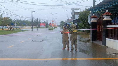
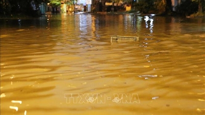
Heavy rain can cause flooding in low-lying areas, urban and industrial areas; flash floods in small rivers and streams; and landslides on steep slopes.
Warning of widespread heavy rain
On the afternoon of September 7, the Ministry of Agriculture and Environment said that from September 9 to the night of September 10, in the mountainous and midland areas of the North, there is a possibility of widespread heavy rain with common rainfall of 70-150mm, locally over 300mm in some places.
Heavy rains are likely to cause flooding in low-lying areas, urban and industrial areas, flash floods in small rivers and streams, and landslides on steep slopes.
.")
To proactively respond, the Ministry of Agriculture and Environment has sent a document to the People's Committees of the provinces in the mountainous and midland regions of the North, requesting them to closely monitor forecasts and warnings about heavy rain, risks of floods, inundation, flash floods, and landslides to fully inform authorities at all levels and people.
Localities have deployed forces to inspect and review residential areas along rivers and streams at risk of flooding, flash floods, and landslides to proactively clear the flow and organize the evacuation of people to safety.
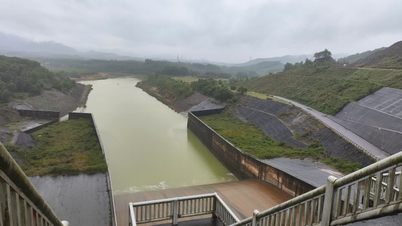
At the same time, it is necessary to inspect and review key works under construction - especially works that have had incidents and small reservoirs that are full of water. Localities proactively deploy measures to ensure safety for industrial parks, urban areas and underground mines and mineral exploitation areas.
The Ministry of Agriculture and Environment also requested provinces to deploy measures to ensure the safety of dykes, reservoirs and downstream areas; arrange permanent forces to operate and regulate, and be ready to handle possible situations.
Source: https://baolaocai.vn/bao-tapah-vao-trung-quoc-nhung-gay-mua-lon-o-viet-nam-post881535.html

![[Photo] President Luong Cuong and United Nations Secretary-General Antonio Guterres chaired the signing ceremony of the Hanoi Convention.](https://vphoto.vietnam.vn/thumb/1200x675/vietnam/resource/IMAGE/2025/10/25/1761370409249_ndo_br_1-1794-jpg.webp)


![[Photo] President Luong Cuong chaired the welcoming ceremony and held talks with United Nations Secretary-General Antonio Guterres](https://vphoto.vietnam.vn/thumb/1200x675/vietnam/resource/IMAGE/2025/10/24/1761304699186_ndo_br_1-jpg.webp)


Comment (0)