

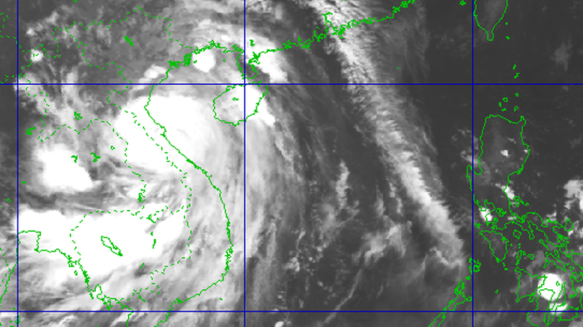
According to the document conveying the conclusion of the Chairman of the City People's Committee Tran Sy Thanh after the working session on investing in a number of bridges across the Red River, Tu Lien Bridge and the road from Tu Lien bridge to Hanoi - Thai Nguyen expressway is being implemented under the EPC contract (design, procurement of materials, equipment, construction). It is expected that in January 2025, the City People's Committee will submit the investment policy to the competent authority for appraisal and approval.
Vice Chairman of the City People's Committee Duong Duc Tuan was assigned to work with the Pacific Construction Group (China) and Vingroup Corporation to agree on a plan to build Tu Lien Bridge to ensure feasibility, efficiency, and early implementation.
The construction site will be located between Nhat Tan Bridge and Long Bien Bridge, connecting from the planned urban main road along Huu Hong Dike with the extended National Highway 5, in Tay Ho District, Long Bien District and Dong Anh District.
The starting point of Tu Lien bridge intersects Nghi Tam street, the end point is through the intersection of National Highway 5, the total length is 4.8 km with 5 intersections including: Nghi Tam, Huu Hong, Bai Giua, Ta Hong and the extended intersection of National Highway 5. The bridge has a cable-stayed architecture combined with torsion beams to create large spans with a lightweight steel frame system, the two main bridge piers are shaped.

The Hanoi Department of Transport will prepare a pre-feasibility study report for the Tran Hung Dao Bridge construction investment project and the two approach roads to be submitted to the competent authority for appraisal, approval and reporting to the city in February 2025.
Tran Hung Dao Bridge is located between Chuong Duong and Vinh Tuy bridges. The south side connects with Tran Hung Dao Street at the border of Hoan Kiem and Hai Ba Trung districts.
In the north, the bridge crosses the Red River bank, follows the western edge of Gia Lam airport area, to the planned intersection with Nguyen Van Linh street (National Highway 5A). The starting point is at the intersection of Tran Hung Dao - Tran Thanh Tong - Le Thanh Tong, the end point is at the intersection with Vu Duc Thuan street.
The main bridge is 900 m long, including 6 spans, the total length of the bridge and approach roads is about 5.5 km, passing through Hoan Kiem, Hai Ba Trung, Long Bien districts. Each direction of the bridge has two lanes for motor vehicles and one lane for mixed vehicles. The spaces are arranged for bicycle lanes at the position close to the arch rim.
The pedestrian section is located outside the arch. The bridge head has a pedestrian ramp. The bridge piers have observation towers to serve the sightseeing needs of the people and create a structural highlight. Both ends of the bridge have parks for people to enjoy and entertain.

Ngoc Hoi Bridge and the two-way approach road will be implemented with public investment capital from Hanoi City, Hung Yen Province and support from the Central Government. According to the roadmap, the Hanoi Department of Planning and Architecture is assigned to advise and propose to the city to organize a competition for the architectural plan of the main bridge across the Red River, reporting to the City People's Committee in December 2024. In January 2025, the city will submit to the competent authority to organize appraisal and approval of the investment policy.
The starting point of Ngoc Hoi bridge connects with the end point of the 3.5 beltway project (section from Phuc La, Van Phu to Phap Van - Cau Gie expressway), the end point connects with the 3.5 beltway in Van Giang district, Hung Yen province.
The project has a total estimated investment of 11,700 billion VND, a total length of about 7.5 km, a cross-section of 80 m (60 m from Ta Hong dike to the end of the route), and a design speed of 80 km/h.
In addition to the 8 existing bridges across the Red River (Thang Long, Chuong Duong, Vinh Tuy, Thanh Tri, Nhat Tan, Vinh Thinh, Long Bien, Viet Tri - Ba Vi), according to the planning until 2030, with a vision to 2050, Hanoi will have 10 more bridges across the river. These are Tu Lien, Tran Hung Dao, Van Phuc, Hong Ha, Me So (Ring Road 4), New Thang Long (Ring Road 3), Vinh Tuy (Phase 2), Thuong Cat, Ngoc Hoi (Ring Road 3, 5), Phu Xuyen.
TB (according to VnExpress)Source: https://baohaiduong.vn/ha-noi-sap-xay-3-cau-lon-vuot-song-hong-398585.html


![[Photo] High-ranking delegation of the Russian State Duma visits President Ho Chi Minh's Mausoleum](https://vphoto.vietnam.vn/thumb/1200x675/vietnam/resource/IMAGE/2025/9/28/c6dfd505d79b460a93752e48882e8f7e)
![[Photo] Joy on the new Phong Chau bridge](https://vphoto.vietnam.vn/thumb/1200x675/vietnam/resource/IMAGE/2025/9/28/b00322b29c8043fbb8b6844fdd6c78ea)
![[Photo] The 4th meeting of the Inter-Parliamentary Cooperation Committee between the National Assembly of Vietnam and the State Duma of Russia](https://vphoto.vietnam.vn/thumb/1200x675/vietnam/resource/IMAGE/2025/9/28/9f9e84a38675449aa9c08b391e153183)


Comment (0)