
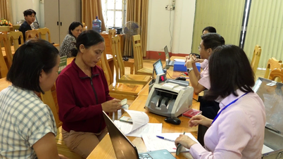
As of September 25, 2025, the whole province has completed reviewing and classifying land data with a total of 5,091,706 land plots.
Of which, 146,289 plots in group 1 have been cleaned, standardized, synchronized with the National Population Database, ready to be exploited to serve administrative procedures and provide public services; 2,477,582 plots in group 2 need to continue to edit, supplement, and authenticate land user information (of which 843,995 plots have initial authentication information, waiting to be updated); group 3 includes 2,467,835 plots that need to rebuild a new database.

The reconciliation work with the National Population Database has authenticated 990,284/2,623,871 land plots, reaching 37.8% of the plan.
Lao Cai Department of Natural Resources and Environment has sent a detailed list of 843,995 land plots requiring additional information to the Provincial Police and 96/99 communes and wards for coordination and verification; at the same time, it continues to review the remaining 1,633,587 land plots.
At the same time, Lao Cai Department of Natural Resources and Environment coordinates with the People's Committee at the commune level to collect, scan/photograph land use right certificates and citizen identification cards to update the system.

In particular, regarding the task of arranging and reorganizing the land database after merging administrative units; adding land plot identification codes, connecting with the national digital address platform and other national databases, completing 2 administrative unit references (administrative unit codes of 320 old commune-level units into 99 new commune-level units) and cadastral map sheet reference tables (cadastral map sheets according to old and new administrative units) to perform data correction from 3 levels to 2 levels and synchronize data to the National Land Database (VNLIS).
According to the Department of Natural Resources and Environment, the tasks are being implemented on schedule according to Plan 515, with close coordination between the Provincial Police and the People's Committees of 99 communes and wards, to ensure quality and efficiency, aiming to authenticate land data at over 95%.
Source: https://baolaocai.vn/hoan-thanh-ra-soat-phan-loai-du-lieu-hon-5-trieu-thua-dat-tai-lao-cai-post883129.html

![[Photo] Panorama of the cable-stayed bridge, the final bottleneck of the Ben Luc-Long Thanh expressway](https://vphoto.vietnam.vn/thumb/1200x675/vietnam/resource/IMAGE/2025/9/30/391fdf21025541d6b2f092e49a17243f)
![[Photo] President Luong Cuong receives President of the Cuban National Assembly Esteban Lazo Hernandez](https://vphoto.vietnam.vn/thumb/1200x675/vietnam/resource/IMAGE/2025/9/30/4d38932911c24f6ea1936252bd5427fa)
![[Photo] The 1st Congress of Phu Tho Provincial Party Committee, term 2025-2030](https://vphoto.vietnam.vn/thumb/1200x675/vietnam/resource/IMAGE/2025/9/30/1507da06216649bba8a1ce6251816820)
![[Photo] Solemn opening of the 12th Military Party Congress for the 2025-2030 term](https://vphoto.vietnam.vn/thumb/1200x675/vietnam/resource/IMAGE/2025/9/30/2cd383b3130d41a1a4b5ace0d5eb989d)
![[Photo] General Secretary To Lam, Secretary of the Central Military Commission attends the 12th Party Congress of the Army](https://vphoto.vietnam.vn/thumb/1200x675/vietnam/resource/IMAGE/2025/9/30/9b63aaa37ddb472ead84e3870a8ae825)


Comment (0)