 |
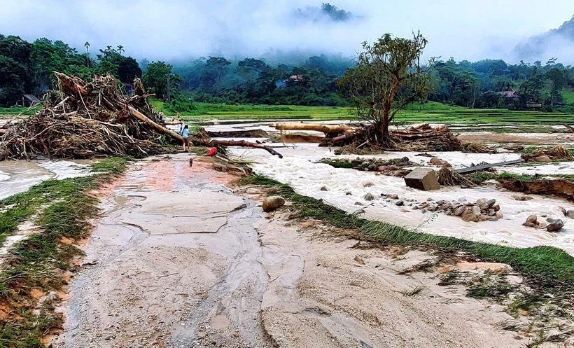
| The border village of Nghe An province was flooded overnight. Photo: VNA |
Risk of flash floods on small rivers and streams, landslides on steep slopes in the above provinces and cities, especially in the districts: Muong Te, Phong Tho, Tam Duong, Than Uyen (Lai Chau province); Dien Bien, Muong Ang, Muong Cha, Muong Nhe, Dien Bien Phu city, Tua Chua, Tuan Giao, Nam Po (Dien Bien province); Bat Xat, Lao Cai city, Sa Pa town, Van Ban, Bao Yen (Lao Cai province); Luc Yen, Mu Cang Chai, Yen Bai city, Tram Tau, Tran Yen, Van Chan, Yen Binh (Yen Bai province); Bac Me, Bac Quang, Dong Van, Hoang Su Phi, Meo Vac, Quan Ba, Quang Binh, Vi Xuyen, Xin Man, Yen Minh (Ha Giang province); Chiem Hoa, Ham Yen, Lam Binh, Na Hang, Son Duong, Tuyen Quang city, Yen Son (Tuyen Quang province); Ha Hoa, Tan Son, Thanh Son, Thanh Thuy, Yen Lap (Phu Tho province); Ba Be, Bach Thong, Cho Don, Cho Moi, Na Ri, Ngan Son, Pac Nam, Bac Kan City (Bac Kan province); Dai Tu, Dinh Hoa (Thai Nguyen province); Bao Lac, Bao Lam, Ha Lang, Ha Quang, Hoa An, Nguyen Binh, Quang Hoa, Thach An, Trung Khanh (Cao Bang province); Binh Gia, Trang Dinh (Lang Son province); Ba To, Minh Long, Son Ha, Son Tay, Tra Bong (Quang Ngai province); An Lao, Hoai An, Phu Cat, Phu My, Tay Son, Hoai Nhon town, Vinh Thanh (Binh Dinh province); Dong Xuan, Phu Hoa, Son Hoa, Song Hinh, Tay Hoa (Phu Yen province); Buon Don, Ea Kar, Krong A Na, Krong Bong, Krong Pac, Lak, M'Drak (Dak Lak province); Cu Jut, Dak Glong, Dak Mil, Krong No, Tuy Duc (Dak Nong province); Don Duong, Duc Trong, Lac Duong, Lam Ha, Da Lat city (Lam Dong province).
Warning level of natural disaster risk due to flash floods, landslides, land subsidence due to heavy rain or level 1 flow.
Heavy rains are likely to cause flooding in low-lying areas, urban and industrial areas; flash floods on small rivers and streams, landslides on steep slopes (real-time warning information on areas at risk of flash floods and landslides is provided online on the website of the Department of Hydrometeorology at: https://luquetsatlo.nchmf.gov.vn and in separate bulletins warning of flash floods and landslides).
Flash floods and landslides can have very negative impacts on the environment, threaten people's lives; cause local traffic congestion, affect the movement of vehicles; destroy civil and economic works, causing damage to production and socio-economic activities.
To prevent flash floods and landslides, disaster prevention experts say that provinces and cities need to use structural and non-structural solutions.
Regarding engineering measures, provinces and cities need to plant and protect upstream protective forests, especially in areas that often cause flash floods, to protect the ecological environment, protect the vegetation cover, increase the water retention capacity of the basin, limit the ability to concentrate flood flows, and at the same time build flood-regulating reservoirs in areas where flash floods often occur, clear flood drainage routes, build dykes, flash flood walls, divide flood flows, and build additional spillways in reservoirs.
For non-structural measures, localities need to create flash flood risk zoning maps (high risk; medium risk and areas with low risk of flash floods). This map is one of the important bases for localities to propose measures to prevent flash floods; land use planning to limit development in areas with high risk of flash floods.
For previously unplanned residential areas, localities need to re-plan and resettle, moving people out of areas at high risk of flash floods and landslides.
From 7:00 p.m. on May 28 to 1:00 p.m. on May 29, the provinces in the Northern region had moderate to heavy rain, and in some places very heavy rain such as: Tam Thanh (Phu Tho) 209.8mm, Tan Minh (Lang Son) 179.9mm, Yen Binh (Yen Bai) 135.2mm, Cach Linh (Cao Bang) 118.9mm, Tam Da (Tuyen Quang) 104.8mm.
From 11am to 1pm on May 29, provinces from Quang Ngai to Phu Yen and the Central Highlands had moderate to heavy rain such as: Thach Khe Lake (Binh Dinh) 53.2mm. Son Long 41.2mm (Quang Ngai), Dong Thanh - Lam Ha (Lam Dong) 39.4mm, Nam Nung (Dak Nong) 37.2mm.
Soil moisture models show that some areas in the above provinces are close to saturation (over 85%) or have reached saturation.
Source: https://baophuyen.vn/xa-hoi/202505/khu-vuc-bac-bo-trung-bo-va-tay-nguyen-mua-lon-co-nguy-co-lu-quet-sat-lo-3813c08/














![[Photo] National Assembly Chairman Tran Thanh Man receives Chairman of Morocco-Vietnam Friendship Association](https://vphoto.vietnam.vn/thumb/402x226/vietnam/resource/IMAGE/2025/7/26/b5fb486562044db9a5e95efb6dc6a263)



Comment (0)