
Da Nang is the fourth largest city in Vietnam after Ho Chi Minh City, Hanoi, and Hai Phong in terms of urbanization and socio -economic development. Located on the East Sea coast with the Han River estuary, Da Nang is one of the strategically located port cities in Central Vietnam and one of the five centrally-governed cities.
1. Geographical location
Da Nang City has a natural area of 128,488 hectares (1,284.88 km2), including the Hoang Sa island district of 30,500 hectares. The city has 6 districts: Hai Chau, Thanh Khe, Son Tra, Ngu Hanh Son, Lien Chieu, Cam Le and 2 districts: Hoa Vang and Hoang Sa island district (total land area: 97,988 hectares).
Da Nang has a coastline of approximately 92 km, with a deep-water bay and Tien Sa seaport, and a continental shelf with a depth of 200 m, forming a large shallow water belt suitable for the development of a comprehensive marine economy and international exchange. The coastline boasts many beautiful beaches such as Non Nuoc, My Khe, Thanh Khe, Nam O, Lang Van... with many fascinating natural landscapes, offering great value for tourism and resort development.
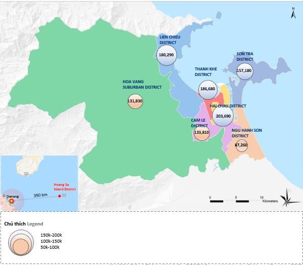
Map of districts and communes of Da Nang city (Source: According to the 2018 Statistical Yearbook)
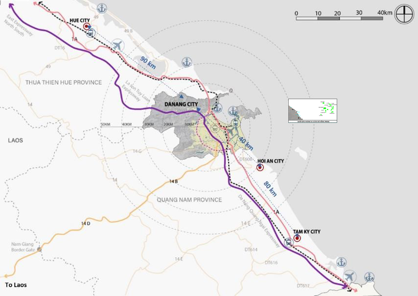
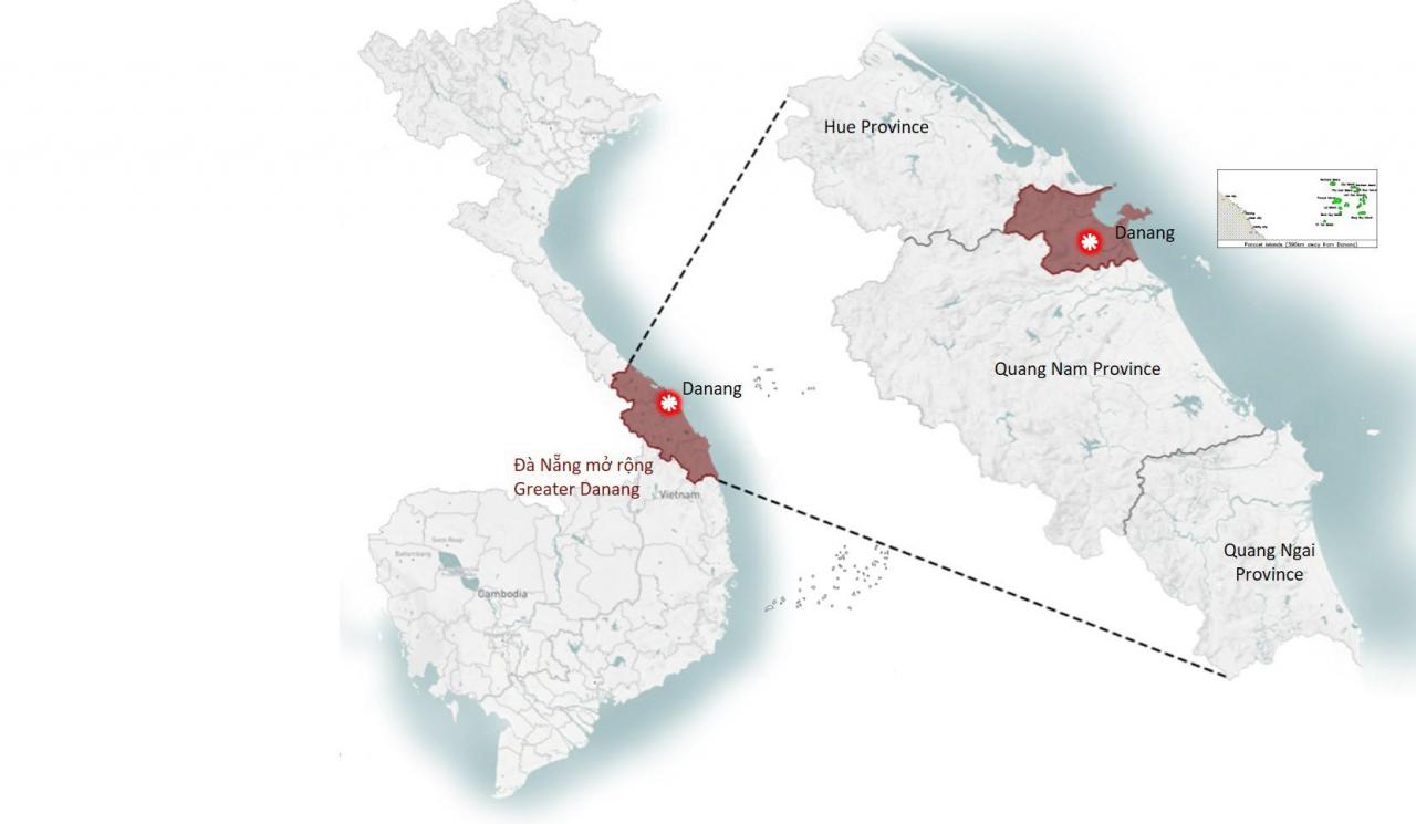
Major cities and connections within the expanded Da Nang area.
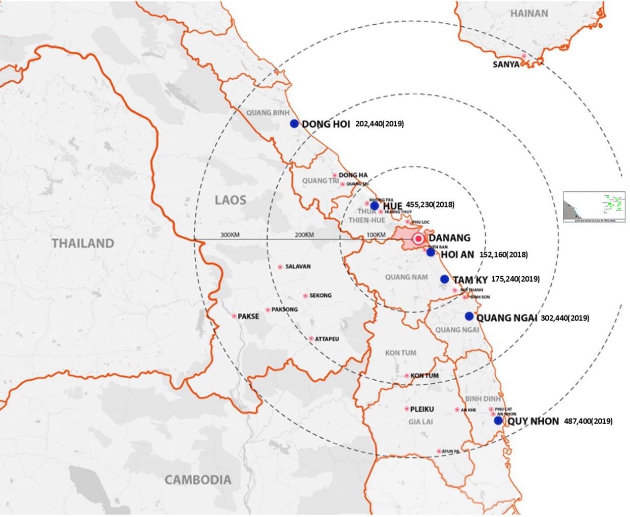
The Greater Da Nang area comprises four provinces and cities: Da Nang, Thua Thien Hue, Quang Nam, and Quang Ngai, with a total population of approximately 5.8 million people. The main cities within a 100km radius of the Greater Da Nang area are Hue, Hoi An, and Tam Ky.
a. Seaport
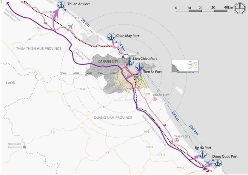
The seaport in Da Nang is expanding.
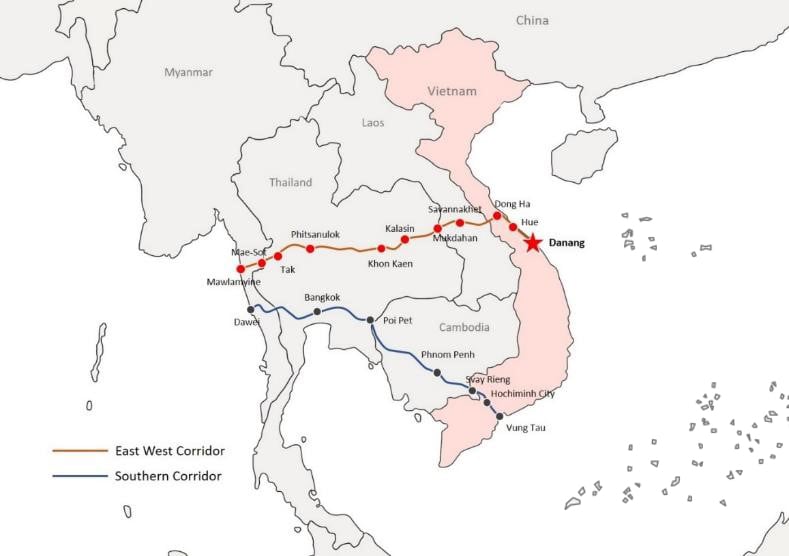
Da Nang Port is the main port in Central Vietnam and the third largest port in the country. Located in Da Nang Bay, covering an area of 12 square kilometers and boasting a convenient transportation system, Da Nang Port is currently a crucial link in the logistics service chain of Central Vietnam. Da Nang Port has also been chosen as the final point of the East-West Economic Corridor, connecting four countries: Myanmar, Thailand, Laos, and Vietnam, serving as the main gateway to the East Sea for the entire region.
The seaport system, linked with logistics services, has been identified as one of the five key economic sectors outlined in Resolution 43-NQ/TW of the Politburo on the construction and development of Da Nang city until 2030, with a vision to 2045. Lien Chieu Port is a project included in the Da Nang City Master Plan until 2030, with a vision to 2045. The total (expected) investment for Lien Chieu Port is VND 7,378.1 billion. Of this, the state will invest VND 3,426.3 billion, and the private sector will invest VND 3,951.8 billion. The project has phased investment from 2020 to 2025.
b. Airport
To support the increasing air traffic, Terminal 2 at Da Nang International Airport became operational in 2017. Additionally, a Terminal 3 has been proposed to further enhance the airport's operational capacity. However, Da Nang Airport also has the potential to cooperate with other airports in the expanded Da Nang area to increase operational capacity. In particular, Phu Bai Airport and Chu Lai Airport are located 64 km north and 86 km south of Da Nang Airport, respectively.
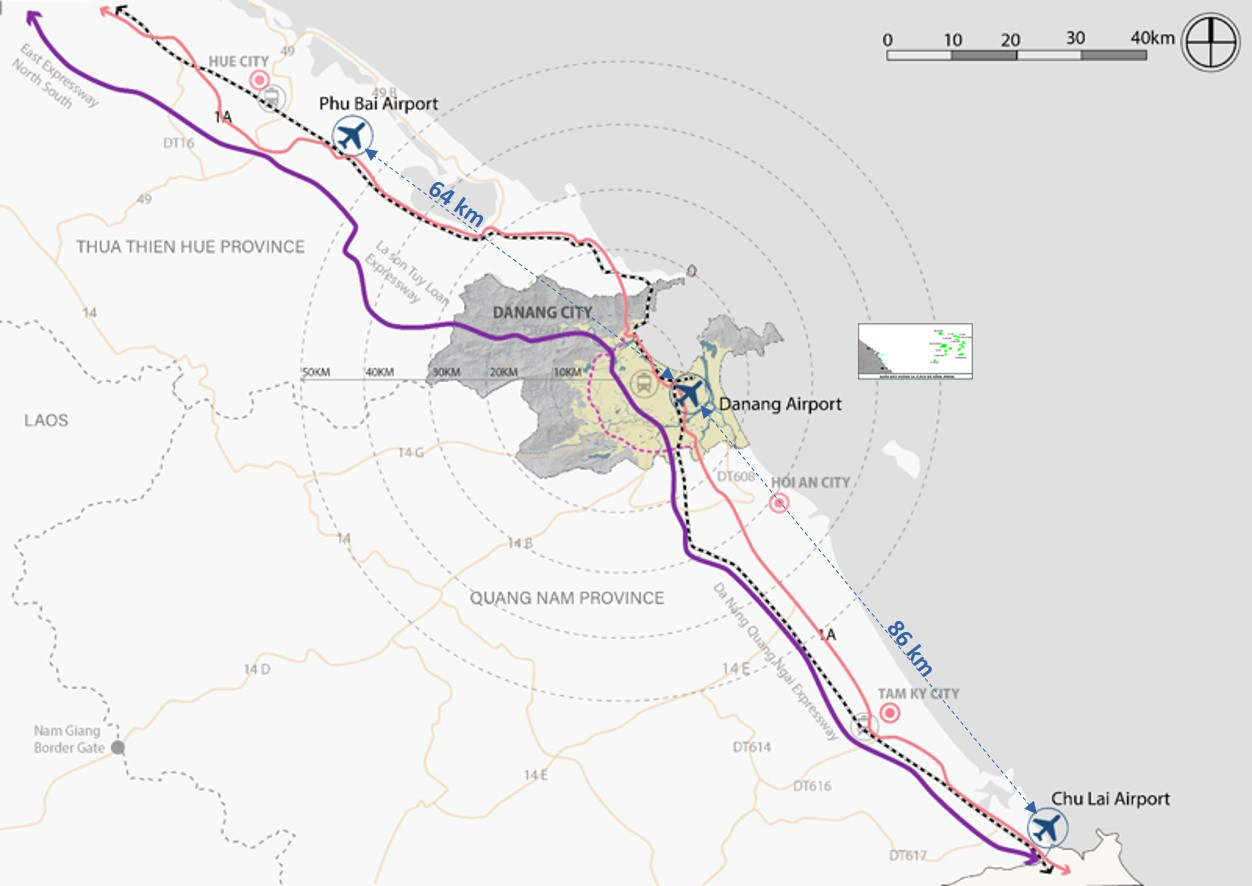
Airport and connectivity in Da Nang are expanding.
c. Integration
Airports and seaports in the Greater Da Nang area are currently well-connected by expressways and national highways. Therefore, integrating these crucial infrastructures and enhancing connectivity between them will increase Da Nang's tourism and logistics potential, thereby creating a robust logistics cluster for the Greater Da Nang area.
d. Regional topography
The landscape surrounding Da Nang is a combination of inland hills and coastal plains. Elevations in the area range from 0m along the coast in the east to 1,800m, peaking in the west along the slopes of the Truong Son mountain range. The high elevations in the west, between Da Nang and Phu Loc district, potentially disconnect from northern Vietnam, and westward from Laos. Furthermore, these areas are characterized primarily by slopes exceeding 40%. This limits development potential in the areas, creating discontinuous development between provinces, leading to a concentration of development along the coast.
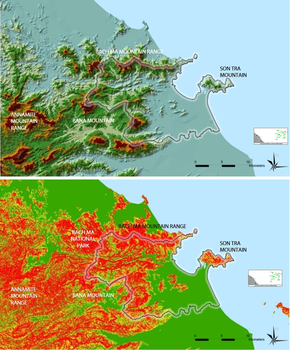
Elevation and slope map of the expanded Da Nang area.
e. Regional hydrology
The major lakes and rivers surrounding and within Da Nang include the Vu Gia - Thu Bon river system in Quang Nam, the Cu De and Han rivers flowing through Da Nang, and the Tam Giang lagoon area in Phu Loc district, Thua Thien Hue province. Together, these sources form the main water supply for the region. Many lakes in the area also serve as regulating reservoirs, including Dong Nghe Lake and Hoa Trung Lake. The high mountainous terrain between Da Nang and Thua Thien Hue province disrupts the hydrological system between the two provinces. From the Vu Gia - Thu Bon river system, the Tuy Loan, Yen, Cai, and Qua Giang rivers flow into Da Nang Bay via the Han River.
Given the water network's connection to Quang Nam, it is crucial for Da Nang to cooperate to ensure effective water resource management and address climate change challenges.
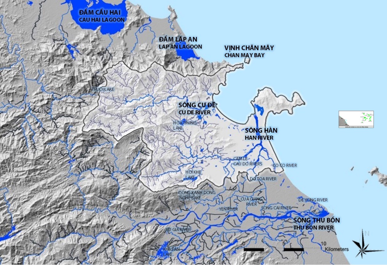
Hydrological map of the expanded Da Nang area
f. Key development nodes
To the north of Da Nang, the Thua Thien Hue province master plan has been approved to establish the Chan May port along with adjacent industrial zones and surrounding residential areas. To the south, new industrial and urban zones have also been proposed along National Highway 1A in Dien Ban district and National Highway 14B in Dai Loc district of Quang Nam province.
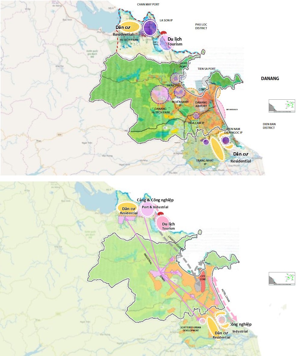
Key development hubs around Da Nang
g. Connection
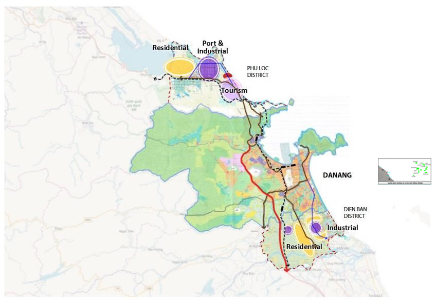
Da Nang's connectivity with the surrounding region.
Currently, there is good connectivity between Da Nang, Dien Ban district in Quang Nam province, and Phu Loc district in Thua Thien Hue province through the national railway system, National Highway 1, and expressways, thereby strengthening regional cooperation.
2. Regional relations
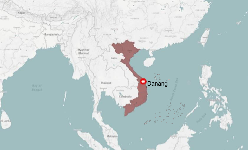
Da Nang City is located in the geographical center of Vietnam. It is one of the 63 centrally governed provinces and cities and a major socio-economic hub of Central Vietnam. Spanning between 15°15' and 16°40' North and 107°17' and 108°20' East, Da Nang lies in the central part of the country, on the North-South transportation axis for road, rail, sea, and air. Da Nang is positioned as an important urban hub in Central Vietnam, supplementing Hanoi and Ho Chi Minh City.
Da Nang is located 764 km north of Hanoi, 964 km south of Ho Chi Minh City, and 108 km northwest of the former imperial capital of Hue. It borders Thua Thien Hue province to the north, Quang Nam province to the south, and Quang Ngai province to the south. Together, these four provinces and cities form the Greater Da Nang region, with a total population of approximately 5.8 million people.
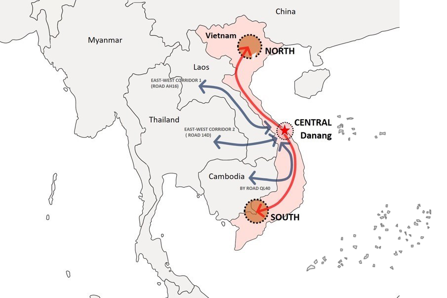
Furthermore, Da Nang is the central point between three famous World Heritage sites: the Imperial City of Hue, the Ancient Town of Hoi An, and the My Son Sanctuary. Regionally and internationally, Da Nang is one of the important gateways to the sea for the Central Highlands and the countries of Laos, Cambodia, Thailand, and Myanmar via the East-West Economic Corridor (EWEC), which terminates at Tien Sa Port. Situated on one of the key international sea and air routes, Da Nang city has a particularly favorable geographical location for vibrant and sustainable development.
Da Nang also serves as an important transit gateway for Laos (a landlocked country) and as an alternative route to Thailand and Myanmar for accessing the South China Sea. In addition, Da Nang has direct flights to other regional hubs such as Shenzhen, Bangkok, Hong Kong, and Singapore.
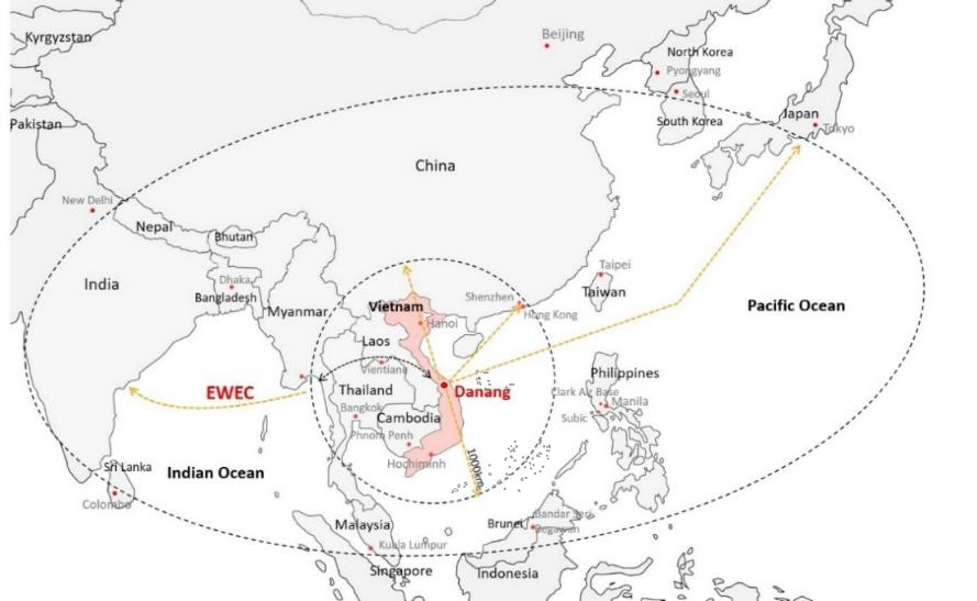
The position of Da Nang city within the ASEAN East-West Economic Corridor.
Location of Da Nang city in Vietnam and neighboring countries
Da Nang is well-connected to the region and key infrastructure through established transport corridors. The East-West Economic Corridor includes a national highway connecting Laos, Thailand, and Myanmar to Da Nang, with Da Nang serving as the eastern gateway. This enhances Da Nang's connectivity with neighboring countries in the Indochina region.
The most important route in Vietnam is National Highway 1, connecting key coastal cities from North to South, including the provinces surrounding Da Nang. In addition, there is a North-South Expressway running parallel to National Highway 1, National Highway 14B, and the Ho Chi Minh Highway running along the inland border to Southern Vietnam, connecting Da Nang with cities such as Kon Tum, Pleiku, and Buon Ma Thuot.
The current national railway network runs only in a North-South direction, connecting major cities in Vietnam along the coast. Da Nang has the potential to develop regional railway connections to enhance its logistics and transportation capabilities.
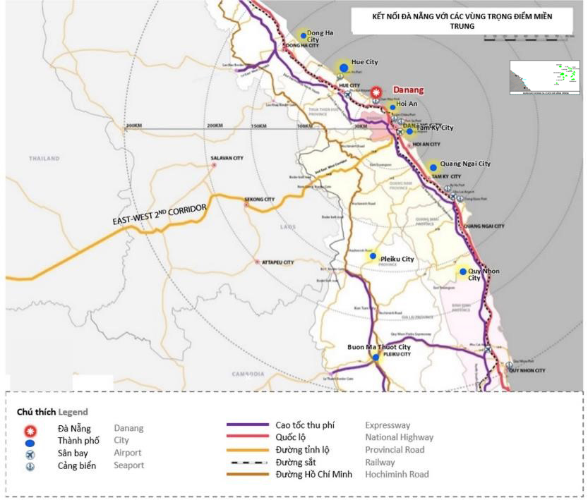
Road and rail connections in Central Vietnam
Currently, Da Nang is the third busiest international airport in Vietnam, with numerous international and domestic connections. Within a 300km radius of Da Nang, there are five airports in central Vietnam and one in Laos, with Da Nang being the largest.
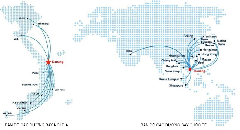
Domestic and international connections to Da Nang Airport
| Airport | City | Connect | |
| Da Nang International Airport | Da Nang | International, Domestic | As shown in the image above. |
| Phu Bai International Airport | Hue | Inland | Da Nang, Hanoi, Ho Chi Minh City, Da Lat |
| Chu Lai International Airport | Tam Ky | Inland | Hanoi, Ho Chi Minh City |
| Phu Cat Airport | Quy Nhon | Inland | Hanoi, Ho Chi Minh City, Hai Phong |
| Pleiku Airport | Pleiku | Inland | Hanoi, Ho Chi Minh City, Hai Phong, Da Nang, Vinh |
| Pakse International Airport | Pakke | International, Domestic | Bangkok, Ho Chi Minh City, Siem Reap, Luang Prabang, Savannakhet, Vientiane,… |
Table: Airport connections around Da Nang city
GENERAL INFORMATION PORTAL
(REFERENCE FROM THE EXPLANATORY COMMITTEE FOR THE ADJUSTMENT OF THE GENERAL PLANNING OF DA NANG CITY TO 2030, VISION TO 2045; STATISTICAL YEARBOOK: 2018 - 2019)
![[Photo] Close-up of an Australian warship visiting Tien Sa port, Da Nang](https://vphoto.vietnam.vn/thumb/1200x675/vietnam/resource/IMAGE/2026/03/28/1774675489416_tau-5-jpg.)


Comment (0)