
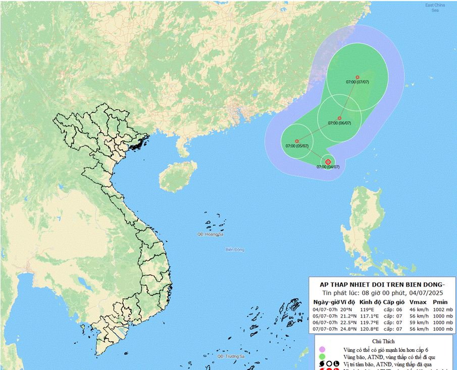
At 7:00 a.m., the center of the tropical depression was at about 20.0 degrees North latitude; 119.0 degrees East longitude. The strongest wind near the center of the tropical depression was level 6 (39-49 km/h), gusting to level 8; moving in the West Northwest direction at a speed of about 10 km/h.
Forecast on the morning of July 5, the tropical depression will move in the West-Northwest direction at a speed of 10-15km/h and is likely to strengthen; about 780km northeast of Hoang Sa special zone, about 780km northeast of Hoang Sa special zone, gusting at level 6-7, sometimes gusting up to level 8.
By the morning of July 6, the low pressure area will move in the East-Northeast direction at a speed of 15-20km/h and is likely to strengthen; level 3 gusts: in the northeastern sea area of the North East Sea, in the southwestern sea area of Taiwan Island (China), gusts of level 7 and 9.
The northeastern sea area of the North East Sea has thunderstorms and strong winds of level 6, sometimes level 7, gusting to level 9, and rough seas. Waves are 2.0-4.0m high. Ships operating in the above-mentioned dangerous areas are likely to be affected by thunderstorms, whirlwinds, strong winds, and large waves.
NDS
Source: https://baothanhhoa.vn/vung-ap-thap-khu-vuc-bien-dong-da-manh-len-thanh-ap-thap-nhiet-doi-253968.htm


![[E-Magazine]: Through the summer rain](https://vphoto.vietnam.vn/thumb/402x226/vietnam/resource/IMAGE/2025/7/4/32930c5a285b4d6d9ddddfdbc06932af)


Comment (0)