
A new low-pressure system has formed near the Philippines. Photo: PAGASA
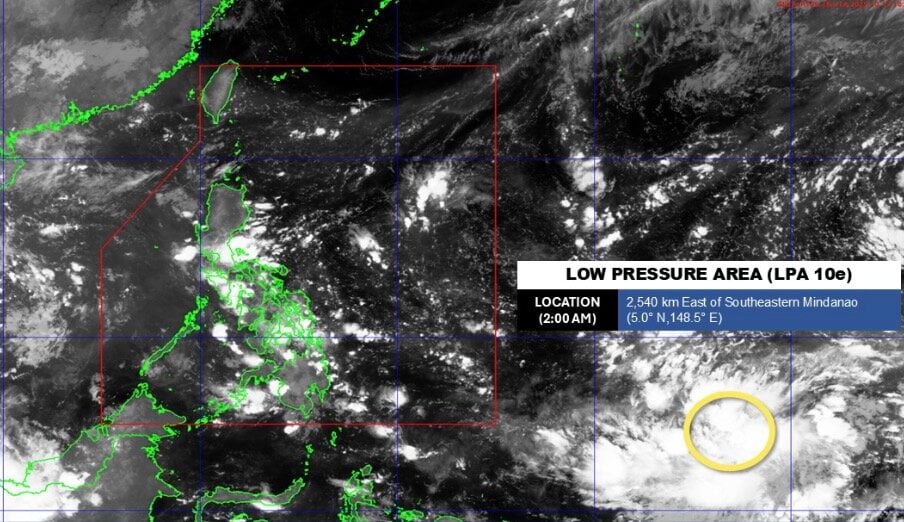
According to the latest storm and low-pressure bulletin from the Philippine Atmospheric, Geophysical and Astronomical Services Administration (PAGASA) on the morning of October 13, a new low-pressure system has been detected 2,540km east of southeast Mindanao.
At 2:00 AM on October 13th, PAGASA determined that the low-pressure system being monitored was currently outside the Philippine Area of Prediction (PAR).
Philippine forecasters believe this low pressure system is unlikely to develop into a tropical depression within the next 24 hours.
In its 4:00 AM weather forecast on October 13, the Philippine weather agency stated that easterly winds would continue to affect eastern Luzon and Visayas.
The Bicol region, Eastern Visayas, Isabela, Aurora, Rizal, and Quezon will be cloudy with scattered rain and thunderstorms, and there is a possibility of flash floods or landslides due to moderate to heavy rainfall.
Meanwhile, in the Metro Manila area and other parts of Luzon and Visayas, cloudy to mostly cloudy skies are forecast, with occasional showers or thunderstorms due to easterly winds.
In Mindanao, the weather will be cloudy to mostly cloudy, with occasional localized showers or thunderstorms.

Typhoon Nakri on the morning of October 13. Photo: Zoom Earth
Before the new low-pressure system forms, experts are also monitoring the development of Typhoon Nakri in the western Pacific basin.
According to the latest storm bulletin from the US Navy's Joint Typhoon Warning Center (JTWC), Typhoon Nakri (known as Quedan in the Philippines and Typhoon No. 23 in Japan) is located 348km south of Camp Fuji and has been moving east-northeast at 30 km/h for the past 6 hours.
The JTWC forecasts that Typhoon Nakri will continue to move east-northeast for the remainder of the forecast period, increasing its speed from 35 km/h to 50 km/h over three days as the system enters the subtropical jet stream to the north.
The latest storm in the western Pacific is forecast to intensify to a maximum speed of 140-150 km/h within the next 12 hours as the system remains in a favorable environment with warm sea surface temperatures and moderate wind shear.
Nakri is expected to leave the warm waters of the Kuroshio Current within the next 36 hours, depriving the storm of its fueling heat source. At that point, the storm will enter a weakening phase.
The storm forecasting models are largely in agreement that Typhoon Nakri will continue to move in a northeast or east-northeast direction for the remainder of the forecast period.
According to Japanese typhoon forecasters, Typhoon Nakri is expected to severely affect the Izu Islands from early morning until nearly noon on October 13.
Sustained wind speeds are expected to reach 108 km/h near the storm's center, with gusts up to 162 km/h. The winds are strong enough to overturn trucks. The sea is expected to be rough, with waves reaching up to 9 meters in height.
The risk of natural disasters is very high on the Izu Islands. Record rainfall and strong winds caused by Typhoon Ha Long last week have eroded the soil and damaged infrastructure. Therefore, residents need to be wary of landslides and strong winds, as well as flooding in low-lying areas, rising river levels, and large waves.
According to the Labor Newspaper
Source: https://baotuyenquang.com.vn/xa-hoi/202510/ap-thap-moi-hinh-thanh-khi-bao-nakri-len-cap-cuc-dai-94d242e/


![[Photo] Reception to welcome General Secretary and President To Lam and his wife on their State visit to the Philippines](https://vphoto.vietnam.vn/thumb/1200x675/vietnam/resource/IMAGE/2026/06/01/1780295488620_vna-potal-chieu-dai-chao-mung-tong-bi-thu-chu-tich-nuoc-to-lam-va-phu-nhan-tham-cap-nha-nuoc-toi-philippines-8798060-7855-jpg.webp)


Comment (0)