
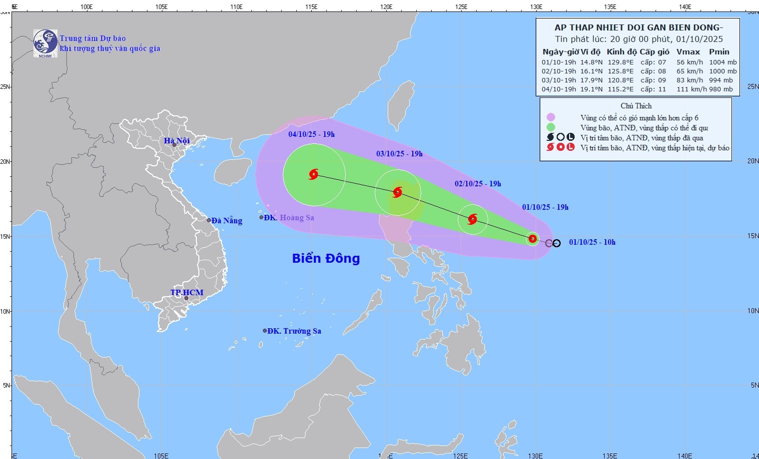
On the evening of October 1, the center of the tropical depression was determined to be at about 14.8 degrees North latitude and 129.8 degrees East longitude, in the sea east of the Philippines.
The strongest wind near the center reaches level 7, equivalent to 50 - 61 km/h, gusting to level 9. This low pressure is moving in a west-northwest direction, at a speed of about 15 km/h.
| Forecast time | Direction, speed | Location | Intensity | Danger zone | Disaster Risk Level (Affected Area) |
| 19 hours October 2nd | West Northwest, 15-20km/h and likely to strengthen into a storm | 16.1N-125.8E; in the sea east of Luzon Island (Philippines) | Level 8, level 10 | ||
| 19 hours October 3 | West Northwest, about 20-25 km/h, likely to strengthen | 17.9N-120.8E; in the area north of Luzon Island (Philippines) | Level 9, level 11 | Latitude 15.0 0 N-20.0 0 N; East of longitude 118.0 0 E | Level 3: Eastern sea area of the North East Sea |
It is forecasted that in the next 48 hours, at 7:00 p.m. on October 2, the tropical depression will strengthen into a storm, located in the sea east of Luzon Island (Philippines), with winds increasing to level 8, gusting to level 10.
After the next 24 hours, on the evening of October 3, the storm is likely to reach level 9, gusting to level 11 when entering the northern area of Luzon Island. The danger zone is now determined from latitude 15 - 20 degrees North and east of longitude 118 degrees East. The entire northeastern area of the East Sea is warned of level 3 natural disaster risk.
In the next 48 to 72 hours, the storm will continue to move west-northwest at a speed of about 25 km/h and is likely to strengthen. It is forecasted that between October 4 and 6, the storm center will move deep into the East Sea, in which the northern sea area including the Hoang Sa archipelago is likely to be directly affected.
Impact on the sea
From the afternoon of October 3, the northeastern area of the East Sea began to have winds gradually increasing to level 6 - 7, then increasing to level 8. The area near the storm's center could reach level 9 - 10, gusting to level 12. Waves were 4 - 6 meters high, causing violent seas.
During October 4-6, the North East Sea area, including the Hoang Sa special zone, is warned of strong winds of level 11-12, gusting to level 15. Vessels operating in this dangerous area are at high risk of encountering strong gusts, whirlwinds and large waves.
Source: https://baonghean.vn/ap-thap-nhiet-doi-gan-bien-dong-co-kha-nang-manh-len-thanh-bao-trong-24h-toi-toi-10-vao-bien-dong-10307505.html
![[Photo] Hanoi morning of October 1: Prolonged flooding, people wade to work](https://vphoto.vietnam.vn/thumb/1200x675/vietnam/resource/IMAGE/2025/10/1/189be28938e3493fa26b2938efa2059e)

![[Photo] Keep your warehouse safe in all situations](https://vphoto.vietnam.vn/thumb/1200x675/vietnam/resource/IMAGE/2025/10/1/3eb4eceafe68497989865e7faa4e4d0e)

![[Photo] President of the Cuban National Assembly visits President Ho Chi Minh's Mausoleum](https://vphoto.vietnam.vn/thumb/1200x675/vietnam/resource/IMAGE/2025/10/1/39f1142310fc4dae9e3de4fcc9ac2ed0)


Comment (0)