
The storm may weaken before making landfall.
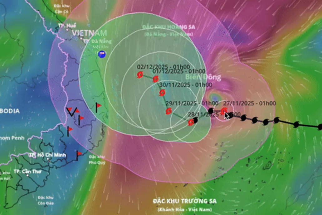
The National Center for Hydro-Meteorological Forecasting said that at 4am on November 27, storm No. 15 (international name Koto) was about 190km east of Song Tu Tay Island. The strongest wind near the storm's center was level 12 (118-133km/h), gusting to level 15.
In the next 24 hours, the storm will move west-northwest at a speed of about 15km/h.
By dawn on November 28, the storm was in the western sea area of the central East Sea, about 190km northwest of Song Tu Tay Island, with a level 12 intensity, gusting to level 15, moving mainly in the West Southwest direction, traveling 5-10km per hour and likely weakening.
From November 29-30, storm Koto moved slowly in the West-Northwest direction, then Northwest, traveling about 5km per hour.
At 4:00 a.m. on November 30, the storm in the western sea area of the central East Sea had reduced its intensity to level 10, gusting to level 13.
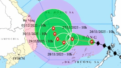
Direction of movement of storm Koto (Photo: Vietnam Disaster Monitoring System).
From the next 72 to 120 hours, the storm moves slowly at a speed of 3-5km/h and gradually weakens in intensity.
Due to the influence of storm Koto, the central East Sea area (including the sea area north of Truong Sa special zone) has strong winds of level 7-9; the area near the storm's eye has strong winds of level 10-12, gusting to level 15; waves 4-6m high, the area near the storm's eye 7-9m; the sea is very rough.
The Japan Meteorological Agency warns ships operating in the above-mentioned dangerous areas. According to the Japan Meteorological Agency, typhoon Koto is at its strongest stage with winds of about 126km/h and will maintain this level until the evening of November 28.
Hong Kong Radio forecasts the storm will reach a peak of 120km/h, then decrease to 105km/h as it moves north.
On November 26, the National Steering Committee for Civil Defense issued a telegram requesting localities from Quang Tri to Lam Dong to closely monitor the storm's developments, inform ships of their movement direction and dangerous areas to proactively avoid it; and prepare rescue forces and means when necessary.
Provinces from Da Nang to Dak Lak have lowered reservoir water levels to receive floods, reserving flood-cutting capacity for downstream areas.
To be ready to respond to storm No. 15, the army mobilized more than 267,000 officers and soldiers along with nearly 6,700 vehicles of all kinds, including 6 helicopters, ready to respond.
Two scenarios of typhoon Koto
Mr. Hoang Phuc Lam, Deputy Director of the National Center for Hydro-Meteorological Forecasting, said that from November 28, Koto moved slowly, only 5-10km/h, so its existence could last until early December.
The storm will begin to be affected by cold air and weaken from the afternoon of November 29.
According to Mr. Lam, when the storm reaches the 113th meridian, about 500km from the Gia Lai - Khanh Hoa coast, with an 80% probability it will change direction to the North, weaken into a tropical depression, then a low pressure area and gradually drift towards the mainland of the Central provinces.
The second scenario, with a 20% probability, the storm does not change direction but continues to move straight into the Gia Lai - Khanh Hoa area. The strongest intensity in the sea area north of Truong Sa special zone can reach level 11, gusting to level 13, then decreasing to level 8 or tropical depression when moving towards the mainland.
With both scenarios, from November 29, the Da Nang - Lam Dong coast will have rain but not as extreme as the rain in mid-November.
Dantri.com.vn
Source: https://dantri.com.vn/thoi-su/bao-koto-dat-cuc-dai-cap-12-ven-bien-da-nang-lam-dong-co-mua-20251127053429458.htm

![[Photo] President Luong Cuong attends the 50th Anniversary of Laos National Day](/_next/image?url=https%3A%2F%2Fvphoto.vietnam.vn%2Fthumb%2F1200x675%2Fvietnam%2Fresource%2FIMAGE%2F2025%2F11%2F27%2F1764225638930_ndo_br_1-jpg.webp&w=3840&q=75)


Comment (0)