
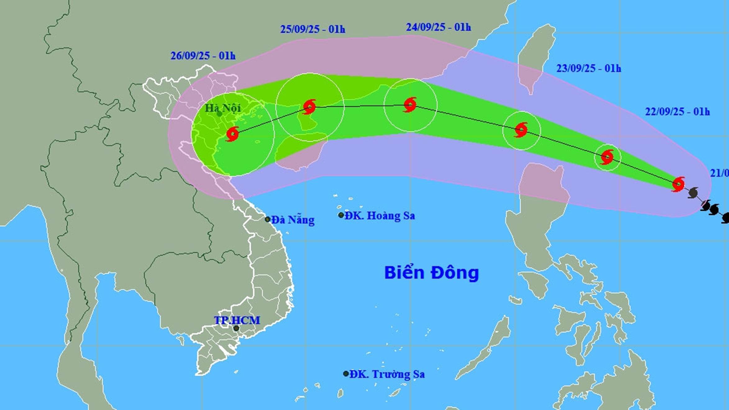
In the next 24 hours, storm RAGASA will move northwest at a speed of 10 - 15 km/h. It is forecasted that by 1:00 a.m. on September 22, storm RAGASA will move west-northwest at a speed of 15 km/h, with the possibility of strengthening.
The National Center for Hydro-Meteorological Forecasting said that at 1:00 a.m. on September 21, the center of storm RAGASA was at about 17.7 degrees North latitude; 127.8 degrees East longitude, about 600 km east of Luzon Island (Philippines). The strongest wind was level 13 (134-149 km/h), gusting to level 16. The storm moved northwest at a speed of 10-15 km/h.
It is forecasted that by 1:00 a.m. on September 22, storm RAGASA will move west-northwest at a speed of 15 km/h, with the possibility of strengthening, at 19.0 degrees North latitude - 124.4 degrees East longitude, about 240 km East-Northeast of Luzon Island. Wind force level 14 - 5, gusting above level 17.
At 1:00 a.m. on September 23, the storm continued to move in the West-Northwest direction at a speed of 15-20 km/h, level 16, gusting to level 17, at 20.3 degrees North latitude -120.3 degrees East longitude, in the sea area north of Luzon Island. Dangerous area: North of latitude 18.0 degrees North latitude, East of longitude 118.0 degrees East longitude. Disaster risk level: level 4 (sea area east of the North East Sea area).
 |
| Location and direction of storm RAGASA at 1:00 a.m. September 21 |
At 1:00 a.m. on September 24, storm RAGASA moved in the West-Northwest direction at a speed of 20-25 km/h and entered the East Sea, at 21.5 degrees North latitude -115.0 degrees East longitude, about 140 km southeast of Hong Kong (China). Wind force level 16, gusting above level 17. Dangerous area is north of latitude 18.0 degrees North latitude, east of longitude 113.0 degrees East longitude. Disaster risk level: Level 4 (Northern East Sea area).
From the next 72 - 120 hours, storm RAGASA will continue to move west, then turn west southwest, at a speed of about 20 km/h and gradually weaken.
Due to the storm's influence, from the afternoon of September 22, the northeastern area of the East Sea had strong winds of level 6 - 7, then increasing to level 8 - 9, gusting to level 11. From the night of September 22, the winds increased to level 10 - 13; near the storm's eye, strong winds of level 14 - 16, gusting above level 17. Waves were 4.0 - 8.0 meters high, near the storm's eye over 10.0 meters. The sea was very rough.
Vessels operating in the danger zone are at high risk of being affected by storms, whirlwinds, strong winds and large waves. In the North and Central East Sea, the sea area from Quang Ngai to Khanh Hoa has scattered showers and thunderstorms.
During the day and night of September 21, the North and Central East Sea, the sea area from Quang Ngai to Ho Chi Minh City will have scattered showers and thunderstorms. During thunderstorms, there is a possibility of tornadoes, strong gusts of wind of level 6-7, and waves over 2.0 meters high. Ships operating in the above areas are at risk of being affected by tornadoes and strong gusts of wind.
In the past 2 hours (from 2-4 am on September 21), Cao Bang province has had moderate rain, some places have had heavy rain such as: Cao Bang - Na Loa Hydropower Plant 61.8mm; Dai Son 52mm;... 2. In the next 3-6 hours, Cao Bang province will continue to have rain with common accumulated rainfall from 10-20mm, some places over 40mm. In the next 6 hours, there is a risk of flash floods on small rivers and streams, landslides on steep slopes in Cao Bang province, especially in the communes/wards: Be Van Dan, Doc Lap, Duc Long, Kim Dong, Minh Khai, Phuc Hoa, Quang Long, Thach An, Vinh Quy. Warning level of natural disaster risk due to flash floods, landslides, land subsidence due to heavy rain or water flow: Level 1.
Flash floods and landslides can have a very negative impact on the environment, threaten people's lives; cause local traffic congestion, affect the movement of vehicles; destroy civil and economic works, causing damage to production and socio-economic activities. Local authorities should pay attention to reviewing bottlenecks and vulnerable locations in the area to take preventive and response measures.
According to PV/VOV.VN
Source: https://baovinhlong.com.vn/thoi-su/202509/bao-ragasa-dang-di-chuyen-theo-huong-tay-tay-bac-co-kha-nang-manh-them-c1f088a/

![[Photo] President Luong Cuong presents decisions on conferring titles and appointing Vietnamese Ambassadors](https://vphoto.vietnam.vn/thumb/1200x675/vietnam/resource/IMAGE/2025/10/10/1760074419606_ndo_br_1-jpg.webp)


Comment (0)