
 |
Graphic image from Zoom Earth platform taken at 9:30 a.m. on September 29 (Vietnam time) shows that storm No. 10 (Bualoi) is still on the Vietnamese mainland. The 9:00 update recorded the center of the storm at about 19.0 degrees North latitude, 104.7 degrees East longitude, on the mainland of the Nghe An - Central Laos border area. Photo: Zoom Earth . |
  |
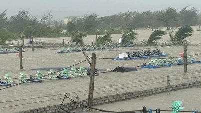
Earlier in the morning of the same day, storm No. 10 made landfall and caused heavy rains over a wide area in the Northern and North Central regions. Graphical images taken at 1 a.m. on September 28 and 29 (Vietnam time) show the storm moving rapidly towards the mainland. According to records, the storm's strongest wind speed was at level 9 (75-88 km/h), gusting to level 11. Photo: Zoom Earth . |
 |
On Zoom Earth, users can adjust the satellite or map view, details such as wind direction, real-time rainfall, data updated every 10 minutes. In addition to satellite images, Zoom Earth provides information on storm tracks, wind speeds, pressure, storm overview information... Photo: Zoom Earth . |
 |
Storm No. 10 appeared right after Storm No. 9 (Ragasa), formed from a tropical depression off the coast of the Philippines. After sweeping the central region of the country on September 26, the storm entered the East Sea on the evening of September 26. The photo above shows the movement of Storm No. 10 from 6:00 to 9:30 on September 29, taken by Japan's Himawari-9 satellite. Photo: Tropical Tidbits . |
 |
This image in water vapor tracking mode was taken by Himawari-9. The satellite, operated by the Japan Meteorological Agency (JMA), was launched in November 2016. It provides detailed information on typhoons, rainfall and other weather phenomena for East Asia, Japan and the Western Pacific , supporting disaster forecasting and monitoring. Photo: Tropical Tidbits . |
 |
Image provided by the Philippine Atmospheric, Geophysical and Astronomical Services Administration (PAGASA) at 10:00 a.m. on September 29 (Vietnam time). Previously, Typhoon Bualoi made landfall in the Philippines on September 26, causing heavy damage. Tens of thousands of people had to leave their homes to avoid the storm, rescue efforts were hampered by power outages, and many roads were deeply flooded. Photo: PAGASA . |
 |
Color infrared image taken by Himawari-9 satellite from 7 p.m. September 28 to 9 a.m. September 29 (Vietnam time). With a very fast moving speed (sometimes twice as fast as a normal storm), strong intensity and west-northwest moving direction, Bualoi is the strongest storm to impact our mainland since the beginning of the year. Photo: NOAA . |
 |
Satellite capture of storm No. 10 from the East Sea at 10:00 on September 29. It is forecast that by noon today, the storm will weaken into a tropical depression and move to Upper Laos. From September 29 to September 30, the area from Thanh Hoa to Ha Tinh , the Northern Delta and Phu Tho, the southern provinces of Son La and Lao Cai will continue to have heavy to very heavy rain with common rainfall of 150-250 mm, in some places over 400 mm. Photo: CIRA . |
Source: https://znews.vn/bao-so-10-do-bo-viet-nam-nhin-tu-ve-tinh-post1589192.html
![[Photo] General Secretary To Lam chairs the meeting of the Central Steering Committee on preventing and combating corruption, waste and negativity](https://vphoto.vietnam.vn/thumb/1200x675/vietnam/resource/IMAGE/2025/9/29/fb2a8712315d4213a16322588c57b975)
![[Photo] General Secretary To Lam receives US Ambassador to Vietnam Marc Knapper](https://vphoto.vietnam.vn/thumb/1200x675/vietnam/resource/IMAGE/2025/9/29/c8fd0761aa184da7814aee57d87c49b3)
![[Photo] National Assembly Chairman Tran Thanh Man chairs the 8th Conference of full-time National Assembly deputies](https://vphoto.vietnam.vn/thumb/1200x675/vietnam/resource/IMAGE/2025/9/29/2c21459bc38d44ffaacd679ab9a0477c)

![[Photo] General Secretary To Lam attends the ceremony to celebrate the 80th anniversary of the post and telecommunications sector and the 66th anniversary of the science and technology sector.](https://vphoto.vietnam.vn/thumb/1200x675/vietnam/resource/IMAGE/2025/9/29/8e86b39b8fe44121a2b14a031f4cef46)
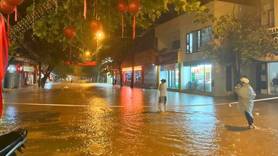
![[Photo] Many streets in Hanoi were flooded due to the effects of storm Bualoi](https://vphoto.vietnam.vn/thumb/1200x675/vietnam/resource/IMAGE/2025/9/29/18b658aa0fa2495c927ade4bbe0096df)


Comment (0)