
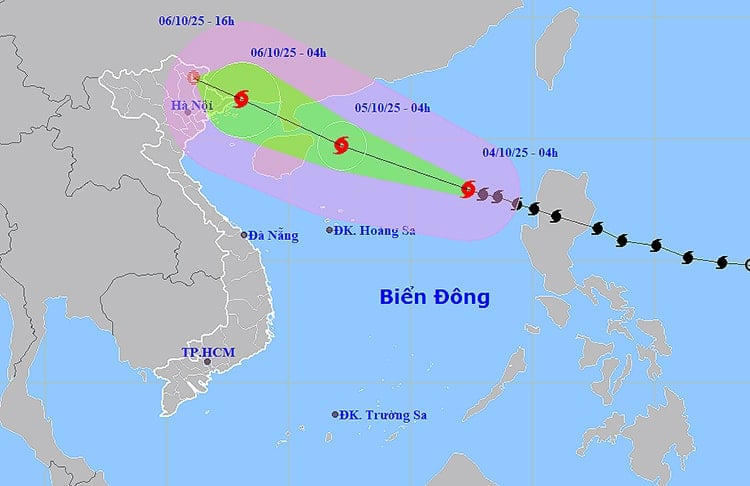
The strongest winds near the center of the storm are at level 11 (103 - 117 km/h), with gusts up to level 14. The storm is moving in a west-northwest direction at a speed of 25 km/h.
By 4:00 AM on October 5th, the storm is forecast to intensify, reaching level 13 with gusts up to level 16, over the northern South China Sea, approximately 130km east of the Leizhou Peninsula (China). The affected area extends from latitude 16.0 to 21.5 degrees North and longitude 110.0 to 119.0 degrees East. The natural disaster risk level in this area is warned at level 3.
Over the next 24 to 48 hours, the storm will continue to move west-northwest at a speed of 20 km/h, entering the northeastern part of the Gulf of Tonkin, then gradually weakening. By the morning of October 6th, the storm's center is expected to be in the northeastern coastal area of Quang Ninh province, with wind speeds decreasing to level 10, gusting to level 13.
By the afternoon of the same day, the storm moved further inland into the northeastern provinces, weakening into a tropical depression and then into a low-pressure area, reducing the level of natural disaster risk to level 3-4.
Forecast of sea impacts: In the northern South China Sea, winds will be strong, reaching levels 8-10, near the storm's center levels 11-13, with gusts up to level 16, and waves 6-8 meters high, resulting in extremely rough seas. From the afternoon of October 5th, the northeastern part of the Gulf of Tonkin, including Bach Long Vi Island, will experience gradually increasing winds of levels 6-7, then 8-9, with waves 2-4 meters high. In the northern Gulf of Tonkin (Van Don, Co To, Cat Hai, Hon Dau), from the evening of October 5th, winds will be strong, reaching levels 8-9, near the storm's center levels 10-11, with gusts up to level 14, and waves 3-5 meters high, resulting in extremely rough seas.
Storm surge in Quang Ninh and Hai Phong is expected to reach 0.4-0.6 meters, posing a risk of flooding in low-lying coastal areas and river mouths. All boats, rafts, aquaculture farms, and coastal structures are advised to urgently seek safe shelter.
On land, from the night of October 5th, the area from Quang Ninh to Ninh Binh will experience strong winds of force 6-8, with winds near the storm's center reaching force 9-10, gusting to force 12, potentially causing trees to fall, roofs to be blown off, and infrastructure damage. Further inland in the Northeast region, winds will reach force 6-7, gusting to force 8-9.
Regarding rainfall, from the night of October 5th to the end of the night of October 7th, Northern Vietnam, Thanh Hoa, and Nghe An will experience heavy to very heavy rain, with rainfall amounts generally ranging from 100 to 200mm, and exceeding 300mm in some areas. Specifically, mountainous and midland areas of Northern Vietnam will experience rainfall of 150 to 250mm, with some areas exceeding 400mm. There is a high risk of flash floods, landslides, and localized flooding, especially in the northern mountainous regions.
Local authorities, relevant agencies, and the public are advised to closely monitor the storm's developments and proactively implement prevention measures to minimize damage to people and property.
Weather forecast for areas across the country:
Hanoi will be cloudy with sunny days and no rain at night. Winds will be southeasterly at force 2-3 during the day and northeasterly to northerly at force 2-3 at night. The lowest temperature will be 24-26°C, and the highest temperature will be 32-34°C, with some areas exceeding 34°C.
The provinces in the Northwest region will be cloudy with sunny days and scattered showers and thunderstorms at night. Light winds. There is a possibility of tornadoes, lightning, and strong gusts of wind during thunderstorms. The lowest temperature will be 23-26°C, with some areas below 22°C. The highest temperature will be 31-34°C, with some areas above 34°C.
The northeastern region of Vietnam will be cloudy with sunny days and scattered showers and thunderstorms at night. Winds will be southeasterly at level 2-3 during the day and northeasterly to northerly at level 2-3 at night. There is a possibility of tornadoes, lightning, and strong gusts of wind during thunderstorms. Minimum temperatures will be 23-26°C, with some mountainous areas below 23°C. Maximum temperatures will be 31-34°C, with some areas exceeding 34°C.
The provinces from Thanh Hoa to Hue will be cloudy with sunny days and scattered showers and thunderstorms at night. Light winds during the day; northerly to northwesterly winds of force 2-3 at night, with westerly to southwesterly winds of force 2-3 in the south. There is a possibility of tornadoes, lightning, and strong gusts of wind during thunderstorms. Minimum temperature 23-26°C. Maximum temperature 31-34°C.
The South Central Coastal region will be cloudy with scattered showers and thunderstorms in some areas, especially in the late afternoon and evening with scattered showers and thunderstorms, and locally heavy rain in some places. Light winds during the day, southwest winds of force 2-3 at night. There is a possibility of tornadoes, lightning, and strong gusts of wind during thunderstorms. Minimum temperature 24-27°C. Maximum temperature 30-33°C, with some areas exceeding 33°C.
The Central Highlands will be cloudy with scattered showers and thunderstorms in some areas, especially in the late afternoon and evening, with localized heavy rain. Southwesterly winds will be at level 2-3. There is a possibility of tornadoes, lightning, and strong gusts of wind during thunderstorms. The lowest temperature will be 19-22°C. The highest temperature will be 29-32°C.
Southern Vietnam will be cloudy with scattered showers and thunderstorms in some areas, especially in the late afternoon and evening, with localized heavy rain. Southwesterly winds will be at level 2-3. There is a possibility of tornadoes, lightning, and strong gusts of wind during thunderstorms. The lowest temperature will be 23-26°C. The highest temperature will be 30-33°C.
Ho Chi Minh City will be cloudy with scattered showers and thunderstorms in some areas, especially in the late afternoon and evening, with localized heavy rain. Southwesterly winds will be at level 2-3. There is a possibility of tornadoes, lightning, and strong gusts of wind during thunderstorms. The lowest temperature will be 24-26°C. The highest temperature will be 31-33°C.
Source: https://baolamdong.vn/bao-so-11-giat-cap-16-de-doa-bac-bien-dong-and-dat-lien-bac-bo-394457.html
![[Photo] General Secretary and President To Lam presides over a meeting on preparations for the review of one year of operation of the three-tiered government system.](https://vphoto.vietnam.vn/thumb/1200x675/vietnam/resource/IMAGE/2026/06/02/1780391821195_a1-bnd-4595-9717-jpg.webp)


![[VIDEO] Save the Children helps children in Bac Ninh return to normal life after natural disaster.](https://vphoto.vietnam.vn/thumb/402x226/vietnam/resource/IMAGE/2025/12/06/1765004276755_cu-u-tro-bn-2-cover20251206131142.jpeg)


Comment (0)