
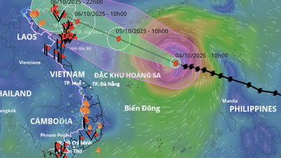
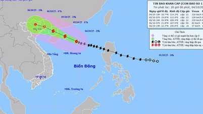
According to the National Center for Hydro-Meteorological Forecasting, at 4:00 a.m. on October 4, the center of the storm Storm No. 11 Matmo in the eastern sea of the North East Sea, about 570km east-northeast of Hoang Sa special zone. The strongest wind near the storm center is level 11 (103-117km/h), gusting to level 14. Moving in the West-Northwest direction, speed about 25km/h.
It is forecasted that by 4am on October 5, storm No. 11 Matmo will move rapidly in the West-Northwest direction, at 20-25km/h per hour, with the possibility of further strengthening. The center of the storm is located in the North East Sea, about 130km east of Leizhou Peninsula (China) with a level 13 intensity, gusting to level 16.
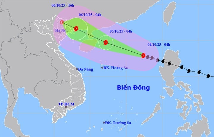
At 4:00 a.m. on October 6, storm No. 11 Matmo did not change direction, moving rapidly at a speed of about 20 km/h, entering the eastern sea area of the Northern Gulf of Tonkin and gradually weakening. The center of the storm was located on the northeastern coastal area of Quang Ninh province. The strongest wind near the center of the storm was level 10, gusting to level 13.
At around 4:00 p.m. the same day, storm No. 11 Matmo continued to move in the West-Northwest direction, at a speed of 15-20 km/h, entering the mainland in the Northeast of the Northern region and gradually weakening into a tropical depression, then a low pressure area.
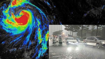
Impact of storm No. 11 Matmo, North East Sea area strong wind level 8-10, area near storm center level 11-13, gust level 16, waves 4-6m high, area near storm center 6-8m, rough seas. Extremely destructive, extremely strong waves, sinking large ships.
From the afternoon of October 5, the sea area east of the northern Gulf of Tonkin (including Bach Long Vi special zone) gradually increased to level 6-7, then increased to level 8-9. From the evening of October 5, the northern Gulf of Tonkin (including Bach Long Vi special zone, Van Don, Co To, Cat Hai and Hon Dau island) gradually increased to level 8-9, waves 2-4m high, the area near the storm center passed level 10-11, gusts level 14, waves 3-5m high, rough seas.
Coastal areas and islands in Quang Ninh - Hai Phong provinces will experience storm surges of 0.4-0.6m. Beware of flooding in low-lying coastal areas and river mouths due to surges and big waves from the afternoon and evening of October 5.
On land, from the night of October 5, on land from Quang Ninh to Ninh Binh, winds will gradually increase to level 6-8, near the storm center, level 9-10, wind force can knock down trees, houses, electric poles, causing very heavy damage. In the inland area of the Northeast, winds will be level 6, in some places level 7, gusting to level 8-9.
From the night of October 5 to the end of the night of October 7, the North, Thanh Hoa and Nghe An will have heavy to very heavy rain with common rainfall of 100-200mm, locally over 300mm. The mountainous and midland areas of the North will have rainfall ranging from 150-250mm, in some places over 400mm. There is a risk of heavy rain, rainfall exceeding 200mm in just 3 hours, posing many potential risks of natural disasters such as flash floods, landslides, and flooding.
Source: https://baolangson.vn/bao-so-11-matmo-giat-cap-14-di-chuyen-nhanh-huong-ve-mien-bac-5060805.html
![[Photo] General Secretary To Lam attends the 8th Congress of the Central Public Security Party Committee](https://vphoto.vietnam.vn/thumb/1200x675/vietnam/resource/IMAGE/2025/10/4/79fadf490f674dc483794f2d955f6045)


![[Photo] Solemn opening of the 8th Congress of the Central Public Security Party Committee, term 2025-2030](https://vphoto.vietnam.vn/thumb/1200x675/vietnam/resource/IMAGE/2025/10/4/f3b00fb779f44979809441a4dac5c7df)
![[Photo] Bustling Mid-Autumn Festival at the Museum of Ethnology](https://vphoto.vietnam.vn/thumb/1200x675/vietnam/resource/IMAGE/2025/10/4/da8d5927734d4ca58e3eced14bc435a3)


![[VIDEO] Summary of Petrovietnam's 50th Anniversary Ceremony](https://vphoto.vietnam.vn/thumb/402x226/vietnam/resource/IMAGE/2025/10/4/abe133bdb8114793a16d4fe3e5bd0f12)

![[VIDEO] GENERAL SECRETARY TO LAM AWARDS PETROVIETNAM 8 GOLDEN WORDS: "PIONEER - EXCELLENT - SUSTAINABLE - GLOBAL"](https://vphoto.vietnam.vn/thumb/402x226/vietnam/resource/IMAGE/2025/7/23/c2fdb48863e846cfa9fb8e6ea9cf44e7)


Comment (0)