
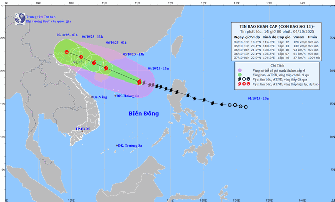
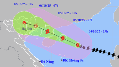
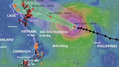
Updated position and path of storm No. 11 Matmo at 2:00 p.m. on October 4. Source: National Center for Hydro-Meteorological Forecasting
This afternoon, October 4, Mr. Nguyen Van Huong - Head of Weather Forecasting Department, National Center for Hydro-Meteorological Forecasting provided the latest comments on storm No. 11 Matmo. Notably, the storm's trajectory is trending north and there are adjustments in rainfall forecasts in some areas.
Mr. Nguyen Van Huong - Head of Weather Forecast Department, National Center for Hydro-Meteorological Forecasting provided forecast information on the developments and impacts of storm No. 11 Matmo at noon on October 4.
Mr. Nguyen Van Huong, what is the forecast for the next developments of storm No. 11 Matmo? Could you please tell us the area where the storm will make landfall?
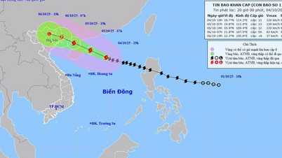
- Currently, the strongest wind near the center of storm No. 11 is at level 11-12. It is forecasted that in the next 24 hours, the storm will continue to move west-northwest and its maximum intensity will reach level 13.
Our calculations of the storm's path show that in the coming time, the storm will shift northward, and will enter the area between Quang Ninh (Vietnam) and Guangxi Province (China). The strongest storm intensity is about level 8 - 9 in Quang Ninh, other areas will have strong winds of level 6 - level 7.
Why do storms tend to intensify rapidly after entering the East Sea, sir?
- When entering the East Sea, the storm tends to strengthen due to relatively favorable sea surface temperature conditions of about 28 - 29 degrees Celsius. While normal temperature of 26 - 27 degrees Celsius is already a good condition for the storm to strengthen.
Besides, the dynamic conditions of wind shear in the northern area of the East Sea (where the center of storm Matmo moves into) are small, favorable for the development of the storm.
The subtropical high pressure, the shape that determines the speed of movement in the direction of storm Matmo, strongly pushes to the west, causing storm Matmo to tend to strengthen and move quickly.
In the next 24 hours, the storm tends to strengthen. However, when passing the north of Leizhou Peninsula (China) and entering the Gulf of Tonkin, the storm will have friction with the ground and wind shear in this area will increase, so the storm's intensity will tend to decrease. Quang Ninh is likely to have strong winds of level 8 - 9 and this is likely to be the strongest wind level when the storm affects the mainland.

Mr. Nguyen Van Huong said it is necessary to guard against the risk of thunderstorms before the storm makes landfall.
As the storm's path tends to shift north, where is the forecasted heavy rain concentrated, sir?
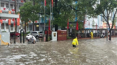
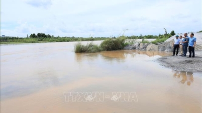
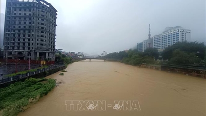
- Due to the influence of storm No. 11 Matmo, from the night of October 5 to October 7, the Northern region will experience widespread heavy rain.
With the storm forecast to move north, the rain will likely be concentrated in the midlands and mountainous areas of the North. The average rainfall from the night of October 5 to October 7 is about 150 - 250mm, with some places over 400mm.
Because the storm moves north, the rain in the Northern Delta and Thanh Hoa will not be as heavy, generally at 70 - 120mm, in some places over 200mm.
In previous storms, the impact of the storm was often before it made landfall. What advice do you have for people?
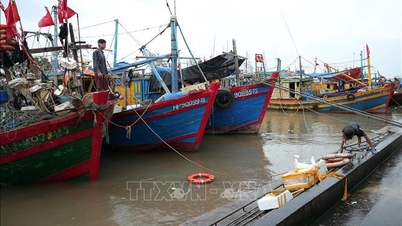
- From the night of October 5, on the mainland, coastal areas from Quang Ninh to Hung Yen, winds will gradually increase to level 6 - 7, near the storm center, level 8 - 9, gusting to level 10 - 11. Inland areas in the Northeast, winds will be strong at level 4 - 5, in some places level 6, gusting to level 7 - 8.
Rain and storm winds are dangerous, but thunderstorms ahead, while the storm's impact is very concerning. Storm No. 11's circulation is wide, so there is a possibility that while the storm has not yet entered and has not directly affected, thunderstorms can still appear in the front part of the storm, focusing on the Gulf of Tonkin, the Northern region.
Thank you very much!
Laodong.vn
Source: https://laodong.vn/moi-truong/bao-so-11-matmo-sap-di-lech-bac-du-bao-moi-nhat-khu-vuc-bao-do-bo-1585864.ldo


![[Photo] Bustling Mid-Autumn Festival at the Museum of Ethnology](https://vphoto.vietnam.vn/thumb/1200x675/vietnam/resource/IMAGE/2025/10/4/da8d5927734d4ca58e3eced14bc435a3)
![[Photo] General Secretary To Lam attends the 8th Congress of the Central Public Security Party Committee](https://vphoto.vietnam.vn/thumb/1200x675/vietnam/resource/IMAGE/2025/10/4/79fadf490f674dc483794f2d955f6045)
![[Photo] Solemn opening of the 8th Congress of the Central Public Security Party Committee, term 2025-2030](https://vphoto.vietnam.vn/thumb/1200x675/vietnam/resource/IMAGE/2025/10/4/f3b00fb779f44979809441a4dac5c7df)


![[VIDEO] Summary of Petrovietnam's 50th Anniversary Ceremony](https://vphoto.vietnam.vn/thumb/402x226/vietnam/resource/IMAGE/2025/10/4/abe133bdb8114793a16d4fe3e5bd0f12)

![[VIDEO] GENERAL SECRETARY TO LAM AWARDS PETROVIETNAM 8 GOLDEN WORDS: "PIONEER - EXCELLENT - SUSTAINABLE - GLOBAL"](https://vphoto.vietnam.vn/thumb/402x226/vietnam/resource/IMAGE/2025/7/23/c2fdb48863e846cfa9fb8e6ea9cf44e7)


Comment (0)