

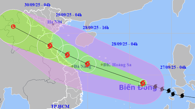
Forecast of location and direction of storm No. 3 at 1:00 p.m. on July 19 (Photo: NCHMF)
According to the National Center for Hydro-Meteorological Forecasting at 1:00 p.m. on July 19, the center of storm No. 3 (storm Wipha) was in the northeastern area of the northern East Sea, the strongest wind near the center of the storm was level 9-10 (75-102 km/h), gusting to level 12. Thus, compared to this morning, storm No. 3 has strengthened by one level.
The latest assessment of the Vietnam Meteorological Agency predicts that around early morning of July 21 (Monday), the storm will move into the Gulf of Tonkin. From the night of July 21 and early morning of July 22, storm No. 3 will affect the coastal mainland of provinces from Quang Ninh to Thanh Hoa.
Storm surge No. 3 on the coast of Quang Ninh - Hai Phong may reach 0.6-0.9m. Large waves combined with high tides may cause flooding in low-lying areas along the coast of Quang Ninh and Hai Phong on the afternoon of July 21 and 22.
From July 21 to 24, in the midland area, the Northern Delta, Thanh Hoa, Nghe An and northern Ha Tinh, there is a possibility of heavy to very heavy rain.
In the next 24 hours, storm No. 3 is forecast to move rapidly in the west-northwest direction at a speed of about 20km/h and is likely to strengthen.
By 1pm tomorrow (July 20), the storm center will be about 370km east of Leizhou Peninsula (China). At this time, the storm intensity will be level 11-12 (103-133km/h), gusting to level 15.
During the next 24 to 48 hours, the storm will move rapidly in the west-southwest direction at a speed of 15-20 km/h and make landfall on the Leizhou peninsula.
At 1:00 p.m. on July 21, the storm center was on the western coast of Leizhou peninsula, the storm intensity was currently level 10-11 (89-117 km/h), gusting to level 13.

Satellite cloud image of storm No. 3 at 1:50 p.m. on July 19 shows the formation of a storm eye (Photo: NCHMF)
In the next 48 to 72 hours, the storm will enter the Gulf of Tonkin, then make landfall in the northern provinces.
At 1 p.m. on July 22, the storm center was on the mainland of the Northern Delta provinces and Thanh Hoa, the storm intensity was now level 8, gusting to level 10. The storm then moved deeper inland and gradually weakened.
Due to the influence of storm No. 3, in the northern sea area of the North East Sea, there are strong winds of level 8-10, near the storm's eye, level 11-12, gusts of level 15, waves 4-6m high. The sea is very rough.
Ships operating in the above-mentioned dangerous areas are likely to be affected by storms, whirlwinds, strong winds and big waves./.
According to Tuoi Tre Newspaper
Source: https://tuoitre.vn/bao-so-3-manh-len-cap-10-kha-nang-anh-huong-quang-ninh-thanh-hoa-20250719095752983.htm
Source: https://baolongan.vn/bao-so-3-manh-len-cap-10-kha-nang-anh-huong-quang-ninh-thanh-hoa-a199058.html
![[Photo] Prime Minister Pham Minh Chinh attends the groundbreaking ceremony of two key projects in Hai Phong city](https://vphoto.vietnam.vn/thumb/1200x675/vietnam/resource/IMAGE/2025/9/27/6adba56d5d94403093a074ac6496ec9d)


Comment (0)