

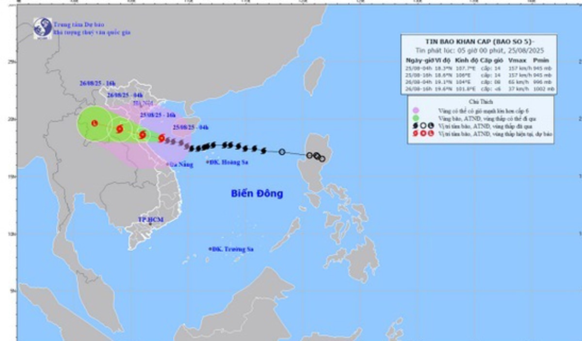
According to the city's Hydrometeorological Station at 4:00 a.m. on August 25, the center of the storm was located at about 18.3 degrees North latitude; 107.7 degrees East longitude, about 220 km from Nghe An, about 200 km East Southeast of Ha Tinh , and about 180 km East Northeast of Quang Tri. The strongest wind near the center of the storm was level 14 (150 - 166 km/h), gusting to level 17; moving in a West Northwest direction at a speed of about 20 km/h.
Forecast at 4:00 p.m. this afternoon, August 25, the storm is moving in the West Northwest direction, about 20 km/h, the center of the storm is about 18.6 degrees North latitude; 106.0 degrees East longitude, on the sea along the coast of Thanh Hoa - North Quang Tri .
Today, the sea area west of the North East Sea is forecast to have strong winds of level 6-7, gusts of level 9, waves 3.0 - 5.0 m high, and rough seas.
The sea area from Thanh Hoa to Quang Tri (including Hon Ngu island, Con Co special zone) has strong winds of level 7-9, then increasing to level 10-11, near the storm center level 12-14, gusting to level 17; waves 5.0-7.0 m high, near the storm center 8.0-10.0 m; rough seas
The sea area south of the Gulf of Tonkin (including Bach Long Vi special zone) has strong winds of level 8-9, gusting to level 11; waves 3.0-5.0 m high; very rough seas.
The northern sea area of Bac Bo Gulf (including Cat Hai special zone, Hon Dau island and Lan Ha bay) has winds gradually increasing to level 6-7, gusting to level 9, waves 1.5-2.5m high, rough seas.
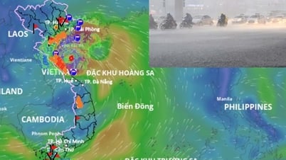
From this morning, August 25, the coastal waters of Hai An Ward, Dong Hai Ward, Nam Trieu Ward, Do Son Ward, Nam Do Son Ward, Duong Kinh Ward, Chan Hung Commune, Hung Thang Commune, Kien Hai Commune will gradually increase in wind to level 5-6, gusting to level 7-8.
On land, from this morning, August 25, the wards/communes in the Northeast and Southeast of the city will have winds of level 4-5, gusting to level 6-7, the wards/communes in the Northwest and Southwest of the city will have winds of level 3-4, sometimes level 5, gusting to level 6.
From early morning of August 25 to the end of August 26, throughout Hai Phong city there will be moderate rain, heavy rain, and thunderstorms in some places.
Inland areas (including forecast locations: Thuy Nguyen, Le Chan, Hai An, Duong Kinh, An Duong, An Lao, Kien An, Tien Lang, Vinh Bao) will have moderate rain, heavy rain and thunderstorms with common rainfall of 70-120mm, locally over 150mm.
The communes and wards of Hai Duong, Chi Linh, Thanh Ha, Kim Thanh, Ninh Giang, Thanh Mien, Cam Giang, Kinh Mon and Tu Ky have rain, moderate rain, heavy rain and thunderstorms in some places with common rainfall of 50-100 mm.
Thunderstorms may cause tornadoes, lightning and strong gusts of wind.
PVSource: https://baohaiphong.vn/bao-so-5-giat-cap-17-toan-hai-phong-co-mua-to-den-rat-to-519022.html


![[Photo] General Secretary To Lam attends the 80th anniversary of Vietnam's diplomacy](https://vphoto.vietnam.vn/thumb/1200x675/vietnam/resource/IMAGE/2025/8/25/3dc715efdbf74937b6fe8072bac5cb30)


![[E-Magazine] Petrovietnam – Strong steps to realize the “Epochal Transformation”](https://vphoto.vietnam.vn/thumb/402x226/vietnam/resource/IMAGE/2025/8/25/e745baade70f4e1e96f5314f65eac658)


Comment (0)