

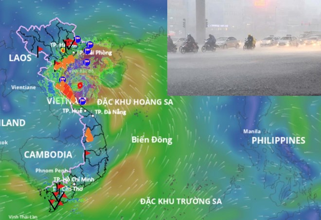
Storm No. 5 Kajiki will cause concentrated rain from August 25 to 26. Storm location source: Vietnam Disaster Monitoring System
Latest update from the National Center for Hydro-Meteorological Forecasting, due to the influence of storm No. 5, at Bach Long Vi station (Hai Phong) there are strong winds of level 7, gusting to level 9; Co To station (Quang Ninh) strong winds of level 6, gusting to level 9; Bai Chay station (Quang Ninh) strong winds of level 6, gusting to level 8; Hon Ngu station (Nghe An) strong winds of level 7, gusting to level 9; Con Co station (Quang Tri) strong winds of level 6, gusting to level 8. In Ha Tinh - Quang Tri provinces, there has been moderate rain, heavy rain, in some places very heavy rain over 150 mm.

Mr. Mai Van Khiem - Director of the National Center for Hydro-Meteorological Forecasting said that storm No. 5 will make landfall from this afternoon to this evening, August 25. Photo: An An
Storm No. 5 tends to decrease slightly in the next 6 hours
At 7:00 a.m. on August 25, the center of the storm was at approximately 18.4 degrees north latitude; 107.2 degrees east longitude, approximately 160 km east-southeast of Nghe An, approximately 145 km east-east of Ha Tinh, approximately 155 km east-northeast of Quang Tri. The strongest wind near the center of the storm was level 14 (150-166 km/h), gusting to level 17; moving west-northwest at approximately 20 km/h.
According to Mr. Mai Van Khiem, Director of the National Center for Hydro-Meteorological Forecasting, in the next 6 hours, the storm is forecast to move west-northwest, about 20 km/hour and its intensity tends to decrease.
"At 1 p.m. on August 25, the center of the storm was at about 18.6 degrees north latitude; 106.3 degrees east longitude, over the sea of Thanh Hoa - Ha Tinh provinces. Wind force level 13-14, gust level 16" - Mr. Khiem said.
The danger zone is from latitude 16.5 to 20.5 degrees north, west of longitude 109.5 degrees east. Level 3 natural disaster risk in the northern Gulf of Tonkin and the sea area from Thanh Hoa to Quang Tri (including Hon Ngu island, Con Co island); level 4 in the coastal areas and mainland of the provinces from southern Thanh Hoa to northern Ha Tinh.
"The storm will make landfall around 3-6 p.m." - Mr. Khiem added.
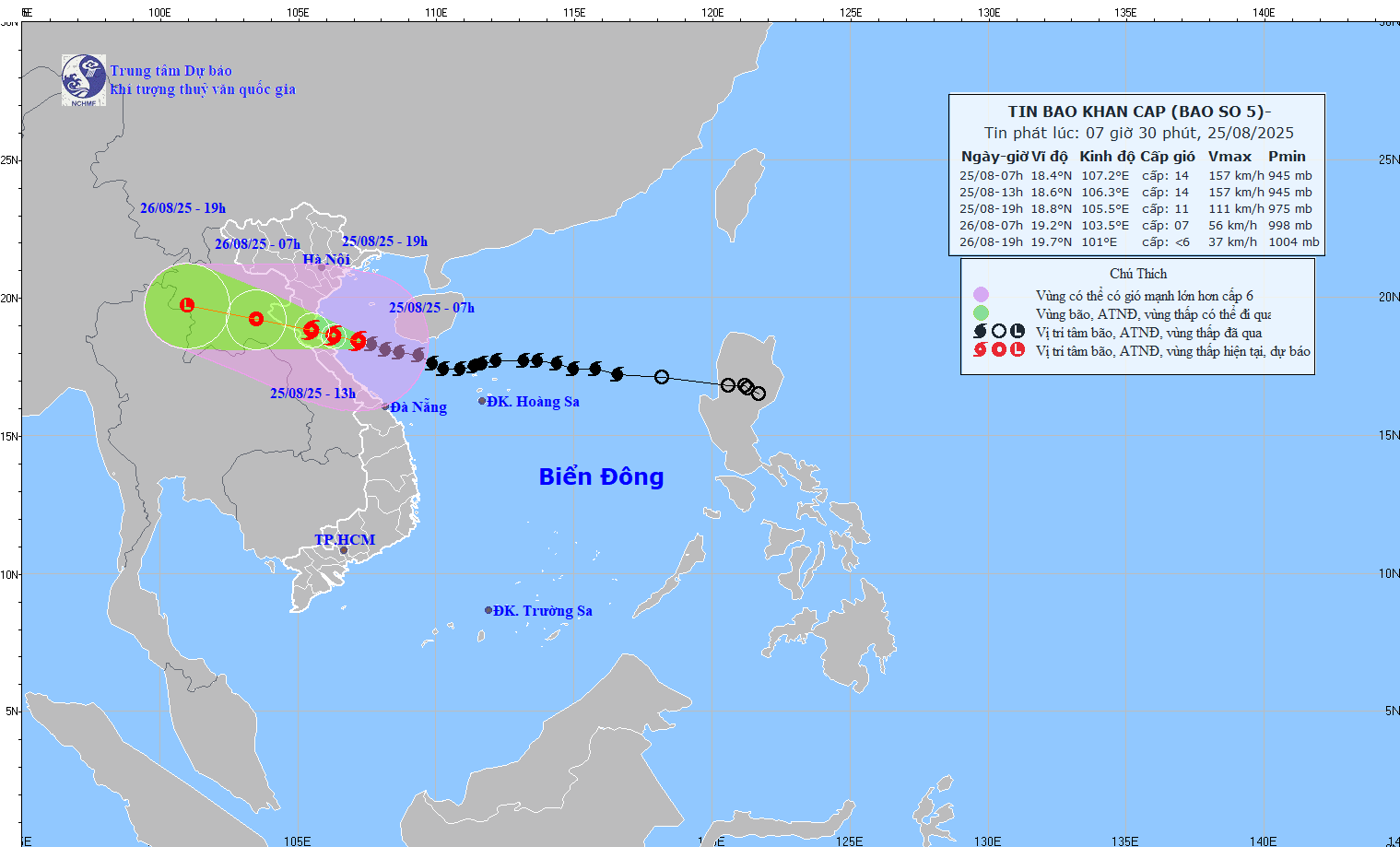
Updated position and path of storm No. 5 at 7:30 a.m. on August 25. Source: National Center for Hydro-Meteorological Forecasting
Forecast in the next 12 hours, the storm moves west northwest, about 20 km/hour.
At 7:00 p.m. on August 25, the center of the storm was at approximately 18.8 degrees north latitude; 105.5 degrees east longitude, on the mainland of Thanh Hoa - Ha Tinh provinces. Wind force level 10-11, gust level 14.
Forecast in the next 24 hours, the storm moves west-northwest, about 20 km/hour, gradually weakening into a tropical depression.
At 7:00 a.m. on August 26, the center was located at about 19.2 degrees north latitude; 103.5 degrees east longitude, in the Central Laos region. Winds were at level 6-7, gusting to level 9. The dangerous area was from latitude 16.5 to 20.5 degrees north latitude, west of longitude 108.5 degrees east longitude.
It is forecasted that in the next 36 hours, the tropical depression will continue to move west-northwest at a speed of 15-20 km/hour, gradually weakening over Central Laos.
At 7:00 p.m. on August 26, the center was at about 19.7 degrees north latitude; 101 degrees east longitude, with winds below level 6.
South Thanh Hoa - North Ha Tinh wind gust level 15-16
According to the meteorological agency, regarding the impact on the sea, the sea area from Thanh Hoa to Quang Tri (including Hon Ngu island, Con Co island) has strong winds of level 8-11, near the storm's eye level 12-14, gusting to level 17; waves 5-7 m high, near the storm's eye 8-10 m, rough seas.
Northern Bac Bo Gulf (including Cat Hai, Co To, Van Don) has strong winds of level 6-7, gusting to level 9; southern Bac Bo Gulf area (including Bach Long Vi) has strong winds of level 8-9, gusting to level 11; waves 3-5 m high, very rough seas.
On land, north of Thanh Hoa there are strong winds of level 8-9, gusting to level 10-11.
"South of Thanh Hoa - north of Ha Tinh has strong winds of level 10-11, near the storm center level 12-14, gusting to level 15-16" - Mr. Khiem emphasized.
In the south of Ha Tinh, Quang Tri and the coast from Quang Ninh to Ninh Binh, there are strong winds of level 6-8, gusting to level 9-10.
From the morning of August 25 to the end of August 26, the midlands and deltas of the North, Lao Cai and from Thanh Hoa to Thua Thien Hue will have widespread heavy rain of 100-150 mm, locally over 250 mm.
"From Thanh Hoa to northern Quang Tri, there will be heavy to very heavy rain of 200-400 mm, with some places over 600 mm. Warning of the risk of heavy rain with high intensity and rainfall of more than 200 mm/3 hours" - Mr. Khiem warned.
From August 25-26, Hanoi will have moderate rain, heavy rain and thunderstorms. On August 25, Da Nang will have rain, moderate rain and thunderstorms. Ho Chi Minh City will have showers and thunderstorms on August 25-26, mainly in the afternoon and evening. During thunderstorms, be on guard against tornadoes and strong gusts of wind.
From the afternoon of August 25-27, Upper and Central Laos had heavy rain of 100-250 mm, with some places in Central Laos having over 500 mm.
Laodong.vn
Source: https://laodong.vn/moi-truong/khoang-15-18h-bao-so-5-kajiki-di-vao-dat-lien-du-bao-moi-nhat-khu-vuc-bao-do-bo-1563053.ldo


![[Photo] General Secretary To Lam attends the 80th anniversary of Vietnam's diplomacy](https://vphoto.vietnam.vn/thumb/1200x675/vietnam/resource/IMAGE/2025/8/25/3dc715efdbf74937b6fe8072bac5cb30)


Comment (0)