

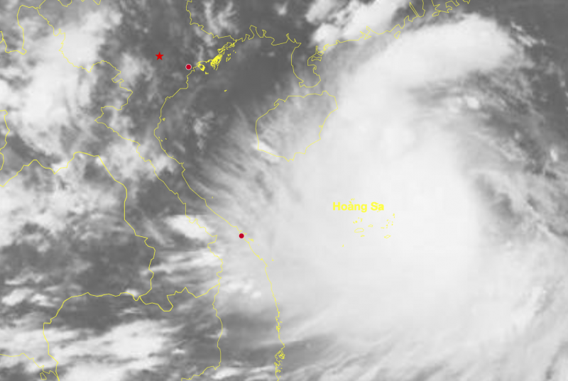
According to the National Center for Hydro-Meteorological Forecasting, this afternoon (August 23), the eye of storm No. 5 is about 300km east-northeast of Hoang Sa special zone. The strongest wind near the eye of the storm is level 9 (75-88km/h), gusting to level 11.
Mr. Nguyen Van Huong, head of the weather forecasting department, National Center for Hydro-Meteorological Forecasting, said that the current weather conditions in the East Sea are quite favorable for storm No. 5 to strengthen. Firstly, the sea surface temperature is high, currently in the area where the storm is likely to pass, the temperature is measured at about 30°C, this is a very favorable factor for the storm to strengthen.
Second, in the upper atmosphere, the wind shear is relatively small. This causes moisture to accumulate, creating favorable conditions for the storm circulation to develop strongly. Third, the southwest wind south of the storm center combines with the east and northeast winds above to create a storm vortex.
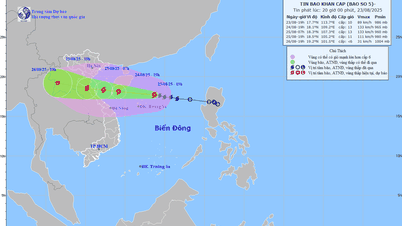
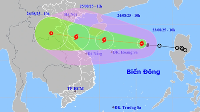
Commenting on the possibility of impact on the mainland, Mr. Huong said that this morning, Chinese radio predicted that the storm could reach level 13 (134-149km/h), with the main area of impact being Ha Tinh - Quang Tri. Japanese radio predicted that the strongest intensity could reach level 12 (118-133km/h).
The Vietnam Meteorological Agency said the storm's maximum intensity could reach level 11-12 (103-133km/h), gusting to level 15, and moving quickly inland. Therefore, as soon as it strengthened into a storm this morning, the National Center for Hydro-Meteorological Forecasting issued an emergency storm warning.
According to Mr. Huong, in the immediate future, today the northern and central areas of the East Sea will be affected by the storm circulation, with winds gradually increasing to level 8-9, then increasing to level 9-10, and possibly even reaching level 12-13, accompanied by waves 4-7m high. Such strong winds and waves will affect all large tonnage vessels operating at sea.
On land, from the evening and night of August 24, the coast from Thanh Hoa to Hue will begin to experience strong winds of level 6-7, then gradually increase as storm No. 5 approaches land. The area near the storm's eye (the storm's landfall center) is likely to experience strong winds of level 10-12, gusting to level 14-15.
Heavy rains are concentrated from Thanh Hoa to Hue, with rainfall ranging from 150-300mm, with some places receiving over 600mm. The Northern Delta region, including the capital Hanoi , is likely to be affected by the storm's distant circulation, with heavy rains expected from August 25 to 27.
"The storm's circulation is wide. Even when storm No. 5 is still 300-400km from the mainland, the clouds ahead can still cause thunderstorms and tornadoes at sea from Quang Ninh to Da Nang, so people need to be on guard against this dangerous weather phenomenon before the storm makes landfall," Mr. Huong noted.
Also on the afternoon of August 23, the Ministry of Agriculture and Environment (MARD) sent an official dispatch to the People's Committees of 12 provinces/cities: Quang Ninh, Hai Phong, Hung Yen, Ninh Binh, Thanh Hoa, Nghe An, Ha Tinh, Quang Tri, Hue, Da Nang, Quang Ngai, Gia Lai regarding the implementation of work to ensure the safety of the dyke system and irrigation works to respond to storm No. 5 and floods.
Localities are required to inspect, review and implement in practice dike protection plans, protect key vulnerable dikes, locations where incidents have occurred but have not been handled or repaired, and unfinished dike works to ensure safety, especially for dike lines facing the sea in storm-hit areas (including urgently completing reinforcement of locations at risk of insecurity before the storm makes landfall).
Strengthen inspection of sea and river dykes, strictly carry out patrolling and guarding work to protect dykes during the rainy and flood season to promptly detect and handle incidents and situations that may occur right from the first hour.
Prepare human resources, materials, vehicles and equipment to protect the dikes; at the same time, check the actual preparation work and proactively respond to incidents and situations that may occur according to the "4 on-site" motto, ensuring safety for the dikes.
Notify owners of vehicles, constructions, and residents and deploy plans to ensure safety for people, property, infrastructure, etc. for activities in coastal areas and on riverbanks. Be ready to evacuate households in dangerous areas, especially coastal areas, outside riverbanks (areas without protective dykes), etc.
Urgently identify a specific list of key irrigation works that are at risk of incidents when there is heavy rain, pay attention to small lakes managed by communes; update the plan to respond to heavy rain, ensure the safety of works in accordance with flood forecasts and the status of works.
Urgently lower the water level of irrigation reservoirs to receive floods according to regulations, ensure absolute safety of the works and do not discharge floods abnormally causing unsafety to downstream areas, especially pay attention not to keep high water levels for reservoirs under construction. Strictly implement early warnings to people in downstream areas before reservoirs discharge floods and when there is a risk of incidents.
Specifically identify areas at risk of flooding when heavy rain occurs; urgently organize thorough drainage of buffer water in areas forecasted to be inundated with heavy rain and promptly operate irrigation works to drain water for production and people's lives when heavy rain occurs.
Source: https://cand.com.vn/Xa-hoi/bao-so-5-tang-cap-12-tinh-thanh-khong-duoc-xa-lu-bat-thuong--i779058/

![[Photo] General Secretary To Lam attends the 80th Anniversary of the Cultural Sector's Traditional Day](https://vphoto.vietnam.vn/thumb/1200x675/vietnam/resource/IMAGE/2025/8/23/7a88e6b58502490aa153adf8f0eec2b2)

![[Photo] Prime Minister Pham Minh Chinh chairs the meeting of the Government Party Committee Standing Committee](https://vphoto.vietnam.vn/thumb/1200x675/vietnam/resource/IMAGE/2025/8/23/8e94aa3d26424d1ab1528c3e4bbacc45)


Comment (0)