
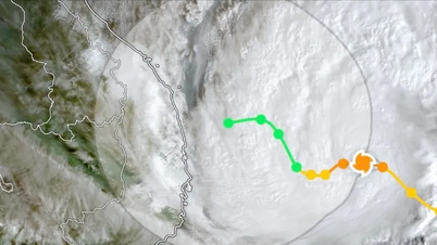
According to the United States National Hurricane Center, this morning, September 25th, Vietnam time, the eye of Typhoon Ragasa (Typhoon No. 9) crossed the northern part of the Leizhou Peninsula (China), sweeping along the southern coast of Guangxi Province (China) towards the Mong Cai area of Vietnam.
 according to US data. Source: Z.E")
According to information from the National Center for Meteorological and Hydrological Forecasting, at 7:00 AM, the storm's center was located at approximately 21.5 degrees North latitude and 108.9 degrees East longitude, about 100km east of Mong Cai ( Quang Ninh ). The strongest wind speed had decreased to only level 8 (62-74 km/h), with gusts up to level 10. In the next 3 hours, the storm will continue to move westward at a speed of about 20 km/h.

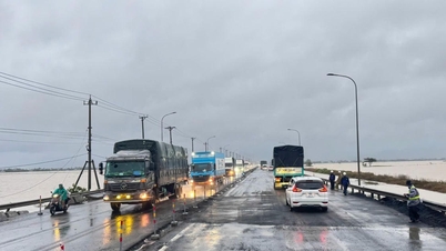
According to data from monitoring stations in the islands, due to the influence of the storm, strong winds of level 7, gusting to level 8, were recorded in the Bach Long Vi special zone. It is forecast that on September 25th, the storm's circulation will continue to cause strong winds in the northern part of the Gulf of Tonkin, especially from Quang Ninh to Hai Phong .
This morning, Hanoi and some areas in Northern Vietnam are still experiencing light rain, but the weather is showing signs of worsening. Some areas in Lao Cai, Tuyen Quang, Thai Nguyen, Lang Son, Quang Ninh, etc., have already experienced rain due to the remnants of the storm.

According to Mr. Hoang Phuc Lam, Deputy Director of the National Center for Meteorological and Hydrological Forecasting, Hanoi and the Northern Delta will experience heavier rainfall from around noon today.
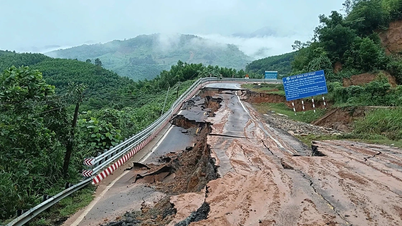
The National Center for Meteorological and Hydrological Forecasting predicts that by 4 PM today, the storm will move westward at a speed of approximately 20 km/hour, making landfall in the northeastern part of Northern Vietnam (Quang Ninh - Lang Son) and weakening into a tropical depression. At this time, the wind speed near the center of the depression will only be level 6, gusting to level 8.
Source: https://www.sggp.org.vn/bao-so-9-da-suy-yeu-con-cap-8-post814572.html
![[Photo] General Secretary and President To Lam works with the Party Committee of the Ministry of Health on the work of Vietnamese traditional medicine.](https://vphoto.vietnam.vn/thumb/1200x675/vietnam/resource/IMAGE/2026/05/20/1779294323718_a1-bnd-2978-3319-jpg.webp)
![[Photo] National Assembly Chairman Tran Thanh Man working with the Standing Committee of the National Assembly's Delegation Affairs Committee.](https://vphoto.vietnam.vn/thumb/1200x675/vietnam/resource/IMAGE/2026/05/20/1779294340023_ndo_br_1-1691-jpg.webp)
![[Image] "Journey of Hope" promotes the organ and tissue donation movement in Vietnam.](https://vphoto.vietnam.vn/thumb/1200x675/vietnam/resource/IMAGE/2026/05/20/1779294400833_1-8910-jpg.webp)


Comment (0)