
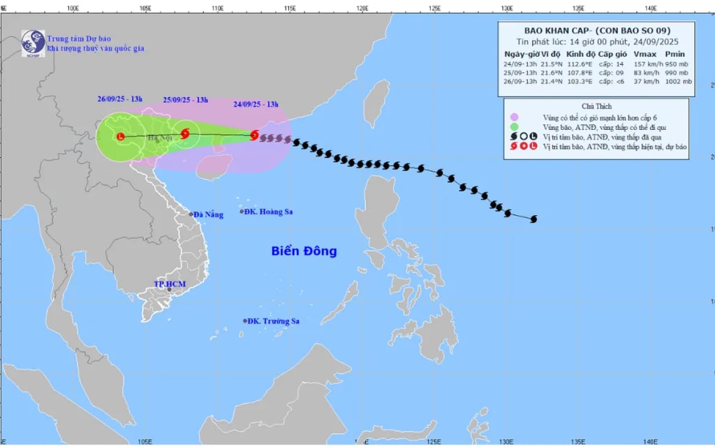
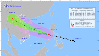
According to the National Center for Hydro-Meteorological Forecasting, at 1:00 p.m. on September 24, the storm center was at about 21.5 degrees North latitude - 112.6 degrees East longitude, about 510 km east of Mong Cai ( Quang Ninh ). The strongest wind near the storm center was level 14 (150-166 km/h), gusting to level 17, moving in the West Northwest direction at a speed of 20 km/h.
At 1 p.m. on September 25, the storm made landfall in the eastern part of Quang Ninh with winds of level 8-9, gusting to level 11, then gradually weakened. Affected areas: the northwestern part of the East Sea (level 4 natural disaster risk), the northern part of the Gulf of Tonkin and the northeastern coast (level 3).
At 1 p.m. on September 26, the storm weakened into a tropical depression and then a low pressure area in the Northwest region, with winds below level 6.
From early morning on September 25, winds gradually increased along the coast from Quang Ninh to Hung Yen (level 6-7, near the storm center level 8-9, gusting to level 11). The Northeast region had winds level 5-6, gusting to level 7-8.
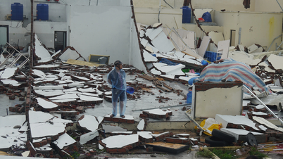
From the night of September 24 to September 26, the North, Thanh Hoa, and Nghe An will have heavy to very heavy rain, generally 150-300 mm, and in some places over 450 mm. There is a high risk of urban flooding, flash floods, and landslides in mountainous areas.
From September 25-27, floods are likely to occur on rivers in the Northern region, Thanh Hoa, and Nghe An; some rivers will reach alert levels 2-3.
Warning: Wide circulation of the storm can cause thunderstorms, tornadoes, and strong gusts of wind both before and during the storm. People should closely monitor forecasts and proactively respond.
Source: https://quangngaitv.vn/bao-so-9-huong-ve-dat-lien-phia-dong-tinh-quang-ninh-6507738.html
![[Photo] General Secretary To Lam receives US Ambassador to Vietnam Marc Knapper](https://vphoto.vietnam.vn/thumb/1200x675/vietnam/resource/IMAGE/2025/9/29/c8fd0761aa184da7814aee57d87c49b3)
![[Photo] Many streets in Hanoi were flooded due to the effects of storm Bualoi](https://vphoto.vietnam.vn/thumb/1200x675/vietnam/resource/IMAGE/2025/9/29/18b658aa0fa2495c927ade4bbe0096df)
![[Photo] General Secretary To Lam chairs the meeting of the Central Steering Committee on preventing and combating corruption, waste and negativity](https://vphoto.vietnam.vn/thumb/1200x675/vietnam/resource/IMAGE/2025/9/29/fb2a8712315d4213a16322588c57b975)

![[Photo] National Assembly Chairman Tran Thanh Man chairs the 8th Conference of full-time National Assembly deputies](https://vphoto.vietnam.vn/thumb/1200x675/vietnam/resource/IMAGE/2025/9/29/2c21459bc38d44ffaacd679ab9a0477c)
![[Photo] General Secretary To Lam attends the ceremony to celebrate the 80th anniversary of the post and telecommunications sector and the 66th anniversary of the science and technology sector.](https://vphoto.vietnam.vn/thumb/1200x675/vietnam/resource/IMAGE/2025/9/29/8e86b39b8fe44121a2b14a031f4cef46)


Comment (0)