
According to the National Center for Hydro-Meteorological Forecasting, at 4am this morning (September 25), storm No. 9 was about 170km east of Mong Cai ( Quang Ninh ). The strongest wind near the storm's center was level 9 (75-88km/h), gusting to level 11.
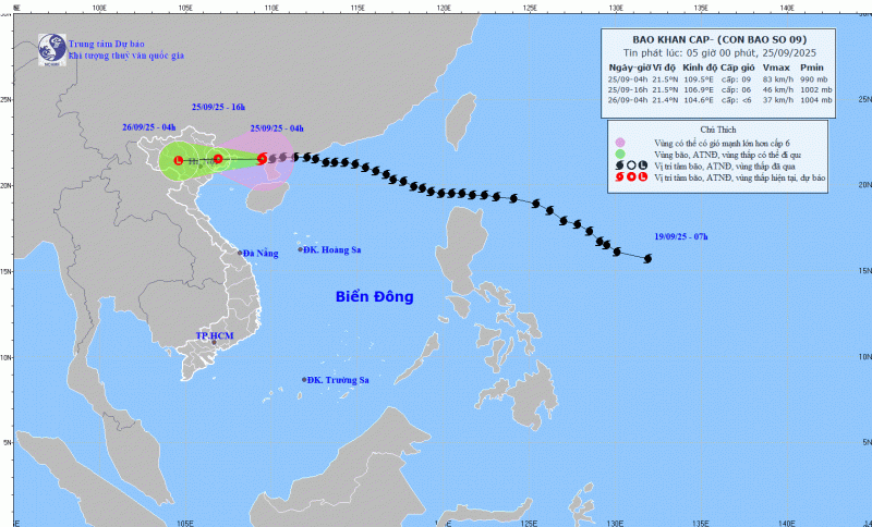
Currently, the storm is moving westward at a speed of about 20km/h. By 4:00 p.m. on September 25, storm No. 9 had a speed of about 20km/h, gradually weakening into a tropical depression on land in the Northeast region of the North. The strongest wind near the storm center is level 6, gusting to level 8. Disaster risk warning level 3 for the northwest sea area of the North East Sea, the North Gulf of Tonkin, and the Northeast coast.
Mr. Mai Van Khiem, Director of the National Center for Hydro-Meteorological Forecasting, said that it is forecast that this afternoon, storm No. 9 will make landfall in Quang Ninh province.
At 4:00 a.m. on September 26, the tropical depression moved westward at a speed of about 20 km/h, gradually weakening into a low-pressure area over the Northwestern region.
Due to the impact of storm No. 9, the Northwestern sea area of the North East Sea has strong winds of level 6-8, gusts of level 10, waves 3.0-5.0m high; rough seas.
The Northern Gulf of Tonkin (including Bach Long Vi, Van Don, Co To, Cat Hai and Hon Dau islands) has strong winds of level 6-7, waves 2.0-3.0m high, near the storm center level 8-9, gusts of level 11, waves 3.0-4.0m high; very rough seas. Ships, boats, and aquaculture areas in the above-mentioned dangerous areas are all strongly affected by strong winds, big waves and storm surges.
On land: Coastal areas from Quang Ninh to Hai Phong have winds gradually increasing to level 6-7, near the storm center level 8, gusting to level 9-10; inland areas in the Northeast, there are strong winds of level 5, in some places level 6, gusting to level 7-8.
From early morning of September 25 to the end of the night of September 26, in the Northern region, Thanh Hoa and Nghe An, there will be heavy to very heavy rain with common rainfall of 150-300mm, locally over 450mm. Beware of heavy rain causing urban flooding.
From September 25 to 27, there is a possibility of a flood on rivers in the Northern region, Thanh Hoa, and Nghe An. The flood peak on Thao River and small rivers is likely to reach level 2-3; the flood peak on Lo River, the upper reaches of Thai Binh River, Hoang Long River, Buoi River, and the upper reaches of Ma River will reach level 1-2, with some rivers above level 2.
Heavy rains are likely to cause flooding in low-lying areas; flash floods in small rivers and streams; and landslides on steep slopes. Due to the influence of the wide storm circulation, it is necessary to guard against the risk of thunderstorms, tornadoes, and strong gusts of wind both before and during the storm.
Source: https://cand.com.vn/Xa-hoi/bao-so-9-suy-yeu-thanh-ap-thap-nhiet-doi-khi-di-vao-quang-ninh-canh-bao-mua-lon-dien-rong--i782407/


Comment (0)