


Photo: nhmf
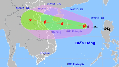
Currently, water levels on rivers from Thanh Hoa to Hue are changing slowly and are still below the alarm level (BĐ)1.
From the night of August 24 to August 28, there was a flood on rivers from Thanh Hoa to Hue, the flood amplitude rose from 4-8m in the upper reaches of rivers, from 2-3m in the lower reaches of rivers. During this flood, the flood peak on small rivers, the upper reaches of Ca River (Nghe An), Ngan Sau River, Ngan Pho River ( Ha Tinh ), Gianh River, Kien Giang River, Thach Han River (Quang Tri) rose to level BĐ2-BĐ3 and above BĐ3; Buoi River, the upper reaches of Ma River (Thanh Hoa), the lower reaches of Ca River (Nghe An), La River (Ha Tinh), Bo River, Huong River (Hue City) rose to level BĐ1-BĐ2; the lower reaches of Ma River rose above level BĐ1.
There is a high risk of flooding in low-lying areas along rivers, urban areas, densely populated areas, flash floods and landslides on steep slopes in mountainous areas from Thanh Hoa to Hue (Real-time warning information on areas at risk of flash floods and landslides is provided online on the website of the Department of Hydrometeorology at: https://luquetsatlo.nchmf.gov.vn and in separate bulletins warning of flash floods and landslides).
Flood risk warning level: Level 2
Flood impact warning: Floods on rivers and streams can cause flooding in low-lying areas along rivers, affecting activities such as water transport, aquaculture, agricultural production, people's lives and socio-economic activities.
LP
Source: https://baothanhhoa.vn/canh-bao-lu-tren-cac-song-tu-thanh-hoa-den-hue-259162.htm

![[Photo] Prime Minister Pham Minh Chinh chairs the meeting of the Government Party Committee Standing Committee](https://vphoto.vietnam.vn/thumb/1200x675/vietnam/resource/IMAGE/2025/8/23/8e94aa3d26424d1ab1528c3e4bbacc45)


![[Photo] General Secretary To Lam attends the 80th Anniversary of the Cultural Sector's Traditional Day](https://vphoto.vietnam.vn/thumb/1200x675/vietnam/resource/IMAGE/2025/8/23/7a88e6b58502490aa153adf8f0eec2b2)


Comment (0)