
According to the National Center for Hydro-Meteorological Forecasting, from July 23 to 25, many dangerous weather patterns will appear.
Heavy rain in many areas
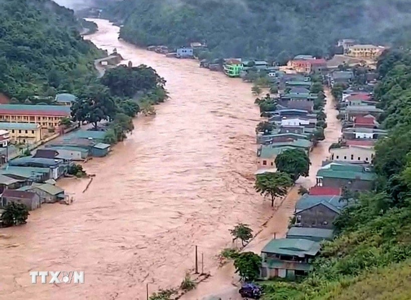
The National Center for Hydro-Meteorological Forecasting said that from 12:30 to 17:30 on July 23, the provinces of Son La, Phu Tho, Lao Cai , Thanh Hoa and Nghe An will continue to have rain with common accumulated rainfall as follows: Son La, Thanh Hoa and Nghe An from 5 - 10mm, some places over 30mm; Phu Tho and Lao Cai from 20 - 40mm, some places over 60mm.
Risk of flash floods on small rivers and streams, landslides on steep slopes in many communes/wards:
- Son La Province : Muong Bang, Ngoc Chien, Van Ho; Chieng Hac, Chieng Son, Doan Ket, Muong Coi, Moc Chau, Moc Son, Thao Nguyen, Van Son, Song Khua, Tan Yen, To Mua, Xim Vang, Xuan Nha;
- Phu Tho Province : Bao La, Cao Son, Da Bac, Mai Chau, Pa Co, Quy Duc, Tan Pheo, Van Son; Cam Khe, Dong Thanh, Duc Nhan, Ha Hoa, Hoang Cuong, Kha Cuu, Long Coc, Mai Ha, Muong Bi, Muong Hoa, Ngoc Son, Phu Tho, Thong Nhat, Tan Lac, Tan Mai, Tan Son, Thinh Minh, Thuong Long, Tien Luong, Tien Phong, Toan Thang, Trung Son, Van Lang, Vinh Chan, Xuan Dai, Yen Lap, Yen Son;
- Lao Cai Province : Ngu Chi Son, Sa Pa Ward, Phinh Ho, Son Luong, Ta Van, Ta Xi Lang, Tu Le; Ban Xeo, Den Sang, Gia Hoi, Hanh Phuc, Lien Son, Minh Luong, Muong Hum, Nam Co, Cau Thia, Nghia Lo, Trung Tam, Pung Luong, Ta Phin, Tram Tau, Van Chan, Y Ty;
- Thanh Hoa Province : Hoa Quy, Hop Tien, Mau Lam, Nhu Thanh, Nhu Xuan, Tan Thanh, Thang Loc, Thanh Phong, Thanh Quan, Van Xuan, Xuan Binh, Xuan Chinh, Xuan Du, Yen Tho; Cong Chinh, Dong Luong, Linh Son, Luan Thanh, Luong Son, Thanh Ky, Thuong Ninh, Van Nho, Van Phu, Xuan Thai, Yen Nhan, Yen Thang; Ba Thuoc, Bat Mot, Cam Van, Co Lung, Dien Quang, Giao An, Hien Kiet, Hoi Xuan, Kien Tho, Minh Son, Muong Chanh, Muong Lat, Muong Ly, Muong Min, Na Meo, Nam Xuan, Ngoc Lac, Ngoc Lien, Nguyet An, Nhi Son, Phu Le, Phu Xuan, Pu Luong, Pu Nhi, Quan Son, Quang Chieu, Son Dien, Son Thuy, Tam Chung, Tam Lu, Tam Thanh, Thach Lap, Thach Quang, Thien Phu, Thiet Ong, Thuong Xuan, Trung Ha, Trung Ly, Trung Son, Trung Thanh, Truong Lam, Xuan Tin, Yen Khuong, Yen Phu;
- Nghe An Province : Bac Ly, Chau Tien, Hung Chan, Huoi Tu, Huu Kiem, Keng Du, Muong Long, Muong Quang, Muong Tip, Muong Xen, My Ly, Na Loi, Nhon Mai, Que Phong, Quy Chau, Thong Thu, Tien Phong, Yen Na; Chau Binh, Chau Hong, Chau Loc, Chieu Luu, Huu Khuong, Luong Minh, Muong Ham, Na Ngoi, Nam Can, Nga My, Nghia Dan, Nghia Hung, Tay Hieu, Thai Hoa, Quy Hop, Tam Hop, Tam Quang, Tam Thai, Tri Le, Tuong Duong; Binh Chuan, Cam Phuc, Chau Khe, Con Cuong, Dong Hieu, Giai Xuan, Mau Thach, Minh Hop, Muong Chong, Nghia Dong, Nghia Khanh, Nghia Lam, Nghia Mai, Tan Ky, Tan Phu, Thanh Binh Tho, Tien Dong, Yen Hoa.
Warning level of natural disaster risk due to flash floods, landslides, land subsidence due to heavy rain or water flow level 1, Nghe An level 2.
")
Flash floods and landslides can have very negative impacts on the environment, threaten people's lives; cause local traffic congestion, affect the movement of vehicles; destroy civil and economic works, causing damage to production and socio-economic activities.
The hydrometeorological agency recommends that local authorities pay attention to reviewing bottlenecks and vulnerable locations in the area to take preventive and response measures.
From 11:00 on July 22 to 11:00 on July 23, the provinces of Son La, Phu Tho, Lao Cai, Thanh Hoa and Nghe An had moderate rain, heavy rain, and some places had very heavy rain such as: Pu Danh (Son La) 179.6mm; Doan Ket (Phu Tho) 138.6mm; Ta Si Lang (Lao Cai) 129.4mm; Xuan Loc (Thanh Hoa) 228.8mm; Dong Van 1 (Nghe An) 236.8mm;... The soil moisture model shows that some areas in the above provinces are nearly saturated (over 85%) or have reached a saturated state.
Warning of high tides in the Northern coastal region
According to information from the National Center for Hydro-Meteorological Forecasting, the tide level along the Northern coast is currently high.
On July 23, Cua Ong station had a water level of 4.45m, high water appeared from 13:00 to 16:00 on July 23. Areas at risk of flooding due to high tides are low-lying areas and areas outside the dike.
Hon Dau Station has a water level of 4.5m, high water appears from 2-5pm on July 23. Areas at risk of flooding due to high tides are low-lying areas and areas outside the dike.
Hon Ngu Station has a water level of 2.8m, high water appears from 13 - 15 hours on July 23. Areas at risk of flooding due to high tides are low-lying areas and areas outside the dike.
Warning, in the next 24 - 72 hours, the water level in the Northern coast will be high. The highest water level is forecasted to reach 4.6m at Cua Ong, 4.1m at Hon Dau and 3.1m at Hon Ngu.
Specifically, on July 24, the water level at Cua Ong station was 4.6m, and high water appeared from 13:00 to 16:00 on July 24. Areas at risk of flooding due to high tides are low-lying areas and areas outside the dike.
Hon Dau Station has a water level of 4.1m, high water appears from 2-5pm on July 24. Areas at risk of flooding due to high tides are low-lying areas and areas outside the dike.
Hon Ngu Station has a water level of 2.9m, high water appears from 13:00 to 15:00 on July 24. Areas at risk of flooding due to high tides are low-lying areas and areas outside the dike.
On July 25, Cua Ong station had a water level of 4.55m, high water appeared from 13:00 to 16:00 on July 25. Areas at risk of flooding due to high tides are low-lying areas and areas outside the dike.
Hon Dau station has a water level of 4.1m, high water appears from 2-5pm on July 25. Areas at risk of flooding due to high tides are low-lying areas and areas outside the dike.
Hon Ngu Station has a water level of 2.8 m, high water appears from 13 - 15 hours on July 25. Areas at risk of flooding due to high tides are low-lying areas and areas outside the dike.
Level 1 flood disaster risk warning.
Low-lying areas along the coast, rivers, and areas outside the dike are likely to be flooded between 13:00 and 17:00 every day.
High tides will slow down the flood drainage process on the river system in the area. In the morning, beware of strong currents flowing offshore when the tide recedes, which are dangerous for maritime activities and sea tourism, especially at ports and beaches.
VNASource: https://baohaiphongplus.vn/canh-bao-nguy-co-lu-quet-sat-lo-o-5-tinh-bac-bo-bac-trung-bo-417057.html


![[Photo] National Assembly Chairman Tran Thanh Man receives Chairman of Morocco-Vietnam Friendship Association](https://vphoto.vietnam.vn/thumb/402x226/vietnam/resource/IMAGE/2025/7/26/b5fb486562044db9a5e95efb6dc6a263)


Comment (0)