
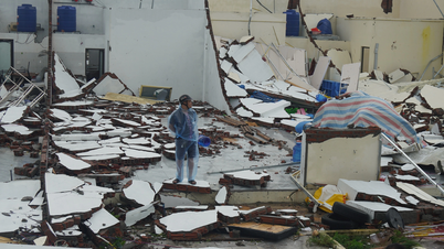
The possibility of storm BUALOI - Storm No. 10 moving into the Central region is the scenario with the highest probability.
According to the National Center for Hydro-Meteorological Forecasting, the possibility of storm BUALOI - Storm No. 10 moving into the Central region is the scenario with the highest probability because during this period, according to the storm's rules, the storm will move into the Central region.
However, the possibility of Storm No. 10 - Storm Bualoi strengthening to super typhoon level or storm above level 13 is not high .
According to Mr. Hoang Phuc Lam, current forecasts show that the maximum intensity of storm BUALOI is not as strong as storm RAGASA. However, to have a more accurate forecast, we need to wait until the storm is stronger, has a stable cloud organization, and a complete storm structure. The National Center for Hydro-Meteorological Forecasting will continue to monitor and update the development of storm BUALOI and around September 25 will issue storm information near the East Sea.
Proactively respond to storm BUALOI near the East Sea
The National Steering Committee for Civil Defense has issued Document No. 04/BCĐ-BNNMT to the People's Committees of coastal provinces and cities from Quang Ninh to An Giang (including: Quang Ninh, Hai Phong, Hung Yen, Ninh Binh, Thanh Hoa, Nghe An, Ha Tinh, Quang Tri, Hue city, Da Nang, Quang Ngai, Gia Lai, Dak Lak, Khanh Hoa, Lam Dong, Ho Chi Minh City, Dong Thap, Vinh Long, Can Tho city, Ca Mau, An Giang) on proactively responding to storm BUALOI near the East Sea.
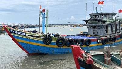
The dispatch stated that, in order to proactively respond to storm BUALOI, the National Civil Defense Steering Committee requested the above provinces and cities to closely monitor warning bulletins, forecasts and developments of the storm. Notify captains and owners of vehicles and boats anchored at ports or operating at sea to proactively prevent and have appropriate production plans, ensuring safety of people and property. The National Civil Defense Steering Committee also requested the provinces to maintain communication to promptly handle possible bad situations.
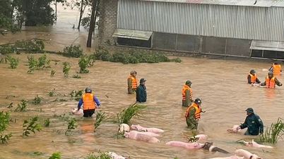
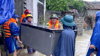
Provinces and cities must prepare forces and means to deploy rescue work when situations arise, and at the same time organize serious on-duty shifts and regularly report to the National Civil Defense Steering Committee ( Ministry of Agriculture and Environment ).
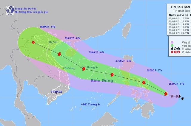
Forecast of storm BUALOI - Storm No. 10 (in the next 24 to 72 hours)
| Forecast time | Direction, speed | Location | Intensity | Danger zone | Disaster Risk Level (Affected Area) |
| 7:00 a.m. September 26 | West Northwest, about 20km/h, likely to strengthen | 13.1N-124.5E | Level 13, level 16 | ||
| 7:00 a.m. September 27 | West Northwest, about 25km/h, moving into the East Sea | 14.7N-118.1E | Level 12, level 15 | Latitude: 12.5-17.0N; East of longitude 116.0E | Level 3: East of the North and Central East Sea |
| 7:00 a.m. September 28 | West Northwest, about 25km/h, likely to strengthen | 15.9N-112.3E | Level 12-13, level 16 | Latitude: 13.0-18.0N; East of longitude 110.0E | Level 3: North and Central East Sea area (including Hoang Sa special zone) |
Storm BUALOI - Storm No. 10 has the potential to become stronger
From the next 72 to 120 hours, starting from the night of October 26, the storm will continue to move rapidly in the West-Northwest direction to the Northwest, traveling about 25km per hour, and its intensity will likely increase.
Warning of the risk of impact of storm BUALOI (storm number 10)
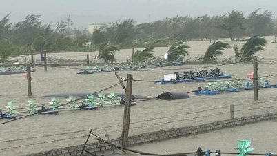
Due to the influence of storm BUALOI from the evening and night of September 26, the sea area to the east of the North and the middle of the East Sea has strong winds of level 6-7, then increasing to level 8-9, the area near the center of the storm has winds of level 10-12, gusts of level 15, waves over 5.0-7.0m high, rough seas, especially dangerous for ships operating in the North and the middle of the East Sea.
Source: https://baonghean.vn/chuyen-gia-nhan-dinh-ve-bao-bualoi-bao-so-10-va-cac-chi-dao-ung-pho-10307124.html
![[Photo] General Secretary To Lam chairs the meeting of the Central Steering Committee on preventing and combating corruption, waste and negativity](https://vphoto.vietnam.vn/thumb/1200x675/vietnam/resource/IMAGE/2025/9/29/fb2a8712315d4213a16322588c57b975)
![[Photo] General Secretary To Lam receives US Ambassador to Vietnam Marc Knapper](https://vphoto.vietnam.vn/thumb/1200x675/vietnam/resource/IMAGE/2025/9/29/c8fd0761aa184da7814aee57d87c49b3)
![[Photo] General Secretary To Lam attends the ceremony to celebrate the 80th anniversary of the post and telecommunications sector and the 66th anniversary of the science and technology sector.](https://vphoto.vietnam.vn/thumb/1200x675/vietnam/resource/IMAGE/2025/9/29/8e86b39b8fe44121a2b14a031f4cef46)
![[Photo] Many streets in Hanoi were flooded due to the effects of storm Bualoi](https://vphoto.vietnam.vn/thumb/1200x675/vietnam/resource/IMAGE/2025/9/29/18b658aa0fa2495c927ade4bbe0096df)

![[Photo] National Assembly Chairman Tran Thanh Man chairs the 8th Conference of full-time National Assembly deputies](https://vphoto.vietnam.vn/thumb/1200x675/vietnam/resource/IMAGE/2025/9/29/2c21459bc38d44ffaacd679ab9a0477c)


Comment (0)