
Some information about the geography of Vietnam.
Geographical location : Vietnam is a country located on the Indochina Peninsula, in Southeast Asia, on the Pacific coast. Vietnam has a land border of 4,550 km bordering China to the north, Laos and Cambodia to the west; and the East Sea to the east. On the map, the Vietnamese mainland is shaped like an S, extending from latitude 23°23 ' North to 8 ° 27' North, 1,650 km long in a north-south direction, with its widest point being approximately 500 km and its narrowest point nearly 50 km.
Vietnam's topography is diverse: hills, mountains, plains, coastlines, and continental shelves, reflecting a long history of geological and topographical development in a monsoon, hot, humid environment with strong weathering. The terrain gradually slopes downwards from northwest to southeast, clearly shown by the direction of flow of major rivers.
Mountains and hills occupy three-quarters of the territory, but are mostly low hills and mountains. Low-lying areas below 1,000 meters account for 85% of the territory. High mountains above 2,000 meters only make up 1%. Vietnam's mountains and hills form a large arc facing the East Sea, stretching 1,400 km from the Northwest to the Southeast. The most massive mountain ranges are located in the West and Northwest, with Fansipan Peak being the highest in the Indochinese Peninsula (3,143m). Towards the east, the mountain ranges gradually decrease in height and often end in a low coastal strip. From Hai Van Pass southward, the terrain is simpler. Here, there are no long limestone mountain ranges, but rather large granite blocks, occasionally rising to high peaks; the rest are continuous plateaus forming the Central Highlands, with the eastern edge uplifted to form the Truong Son mountain range.
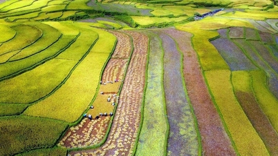
Plains occupy only a quarter of the land area and are divided into many regions by hills and mountains. At the two ends of the country are two large, fertile plains: the Northern Delta (Red River basin, 16,700 km2) and the Southern Delta (Mekong River basin, 40,000 km2). Between these two large deltas lies a chain of smaller, narrower plains, distributed along the central coast, from the plains of the Ma River basin ( Thanh Hoa ) to Phan Thiet, with a total area of 15,000 km2.
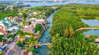
Vietnam faces the sea on three sides—east, south, and southwest—with a coastline stretching 3,260 km, from Mong Cai in the north to Ha Tien in the southwest. The part of the East Sea under Vietnamese sovereignty extends to the east and southeast, encompassing a continental shelf and numerous islands and archipelagos of varying sizes. The Gulf of Tonkin alone contains a cluster of nearly 3,000 islands in the Ha Long Bay and Bai Tu Long Bay areas, as well as Cat Hai, Cat Ba, and Bach Long Vi islands. Further afield are the Hoang Sa and Truong Sa archipelagos. To the southwest and south are the island groups of Con Son, Phu Quoc, and Tho Chu.
Population: The average population in 2025 is estimated at 102.3 million people, an increase of 1,001.6 thousand people, equivalent to a 0.99% increase compared to 2024. Of which, the urban population is 39.4 million people, accounting for 38.6%; the rural population is 62.9 million people, accounting for 61.4%; the male population is 51.0 million people, accounting for 49.9%; and the female population is 51.3 million people, accounting for 50.1%. (Source: General Statistics Office).
Climate : Vietnam is located within the tropics, experiencing high temperatures and high humidity year-round. The north is influenced by mainland China, resulting in a somewhat continental climate. The East Sea profoundly influences the humid tropical monsoon climate of the mainland. The humid tropical monsoon climate is not uniform across Vietnam, forming distinct climatic zones and regions. Vietnam's climate varies seasonally and regionally, from low to high altitudes, from north to south, and from east to west. Due to the strong influence of the northeast monsoon, the average temperature in Vietnam is lower than that of many other countries at the same latitude in Asia.
Vietnam can be divided into two major climate zones: (1) The North (from Hai Van Pass onwards) has a tropical monsoon climate, with four distinct seasons (spring-summer-autumn-winter), influenced by the Northeast monsoon (from the Asian continent) and the Southeast monsoon (blowing through Thailand-Laos and the East Sea), with high humidity. (2) The South (from Hai Van Pass onwards) is less affected by monsoons, so the tropical climate is quite moderate, hot all year round and divided into two distinct seasons (dry season and rainy season).
Furthermore, due to its geographical features, Vietnam has diverse microclimates. Some areas have temperate climates, such as Sa Pa in Lao Cai province and Da Lat in Lam Dong province; while others have continental climates, such as Lai Chau and Son La. These are ideal locations for tourism and relaxation.
The average temperature in Vietnam ranges from 21 ° C to 27°C, gradually increasing from north to south. In summer, the average temperature nationwide is 25°C (Hanoi 23°C, Hue 25°C, Ho Chi Minh City 26 ° C). In winter in the North, temperatures drop to their lowest in December and January. In the northern mountainous regions, such as Sa Pa, Tam Dao, and Hoang Lien Son, temperatures can drop to 0 ° C, with snowfall.
Vietnam receives a very high amount of solar radiation, with sunshine hours ranging from 1,400 to 3,000 hours per year. Average annual rainfall is between 1,500 and 2,000 mm. Air humidity is around 80%. Due to the influence of monsoons and the complex topography, Vietnam often faces adverse weather conditions such as typhoons, floods, and droughts.
Rivers: Vietnam has a dense network of rivers (2,360 rivers longer than 10 km), flowing in two main directions: northwest-southeast and in an arc shape. The two largest rivers, the Red River and the Mekong River, create two vast and fertile delta regions. The river and stream system receives up to 310 billion cubic meters of water annually. The water regime of the rivers is divided into flood and dry seasons. The flood season accounts for 70-80% of the annual water volume and often causes floods.
Land, plants, animals:
Vietnam's soil is diverse and highly fertile, favorable for agricultural and forestry development. Vietnam has a rich and diverse flora (approximately 14,600 plant species). The vegetation is predominantly tropical rainforest, consisting of plants that thrive in sunlight, high temperatures, and high humidity.
Vietnam's animal population is rich and diverse, including many rare species listed in the World Red Book. Currently, 275 species of mammals, 800 species of birds, 180 species of reptiles, 80 species of amphibians, 2,400 species of fish, and 5,000 species of insects have been cataloged. (Dense forests, limestone mountain forests, and multi-layered leaf forests are home to many species of monkeys, langurs, gibbons, and wild cats. Endemic langur species in Vietnam include the white-headed langur, the white-legged langur, and the black langur. Birds also include many rare species such as the ring-necked pheasant and the peacock pheasant. The high mountains of the North are home to many furry animals such as the sun bear, the sun bear, the fox, and the civet...)
Vietnam has preserved and conserved several national parks with rare biodiversity, such as Hoang Lien Son National Park (Fansipan mountain area, Lao Cai), Cat Ba National Park (Quang Ninh), Cuc Phuong National Park (Ninh Binh), Pu Mat National Park (Quang Binh), Phong Nha-Ke Bang National Park (Quang Binh), Bach Ma National Park (Thua Thien Hue), Con Dao National Park (Con Son Island, Ba Ria-Vung Tau), Cat Tien National Park (Dong Nai)... These national parks are places for Vietnamese and international biologists to conduct scientific research, and are also attractive ecotourism destinations. In addition, UNESCO has recognized nine biosphere reserves in Vietnam as World Biosphere Reserves, including: Can Gio Mangrove Biosphere Reserve, Dong Nai Biosphere Reserve, Cat Ba Biosphere Reserve, Red River Delta Biosphere Reserve, Kien Giang Coastal and Island Biosphere Reserve, Western Nghe An Biosphere Reserve, Ca Mau Cape Biosphere Reserve, Cu Lao Cham Biosphere Reserve, and Langbiang Biosphere Reserve.
(Source: Ministry of Foreign Affairs)
Source: https://chinhphu.vn/dia-ly-68387
![[Photo] Prime Minister Pham Minh Chinh presides over meetings of the Government Standing Committee to discuss several important issues.](https://vphoto.vietnam.vn/thumb/1200x675/vietnam/resource/IMAGE/2026/03/16/1773674631996_ndo_br_img-5789-jpg.webp)

![[Photo] Secretary of the National Assembly Party Committee, Chairman of the National Assembly presides over the fourth meeting of the National Assembly Party Committee Executive Board.](https://vphoto.vietnam.vn/thumb/1200x675/vietnam/resource/IMAGE/2026/03/16/1773656046264_ndo_br_bnd-0533-jpg.webp)
![[Photo] General Secretary To Lam receives the Chinese Ministers of Foreign Affairs, National Defense, and Public Security attending the Conference on the “3+3” Strategic Dialogue Mechanism](https://vphoto.vietnam.vn/thumb/1200x675/vietnam/resource/IMAGE/2026/03/16/1773659640884_a1-bnd-0963-2144-jpg.webp)
![[Photo] Prime Minister Pham Minh Chinh receives the Ministers of Foreign Affairs, Defense, and Public Security of China.](https://vphoto.vietnam.vn/thumb/1200x675/vietnam/resource/IMAGE/2026/03/16/1773659638054_ndo_br_dsc-4386-6157-jpg.webp)
![[Photo] Prime Minister Pham Minh Chinh holds a phone call with Angolan President João Manuel Gonçalves Lourenço](https://vphoto.vietnam.vn/thumb/1200x675/vietnam/resource/IMAGE/2026/03/16/1773674632171_ndo_br_dsc-4772-jpg.webp)


Comment (0)