
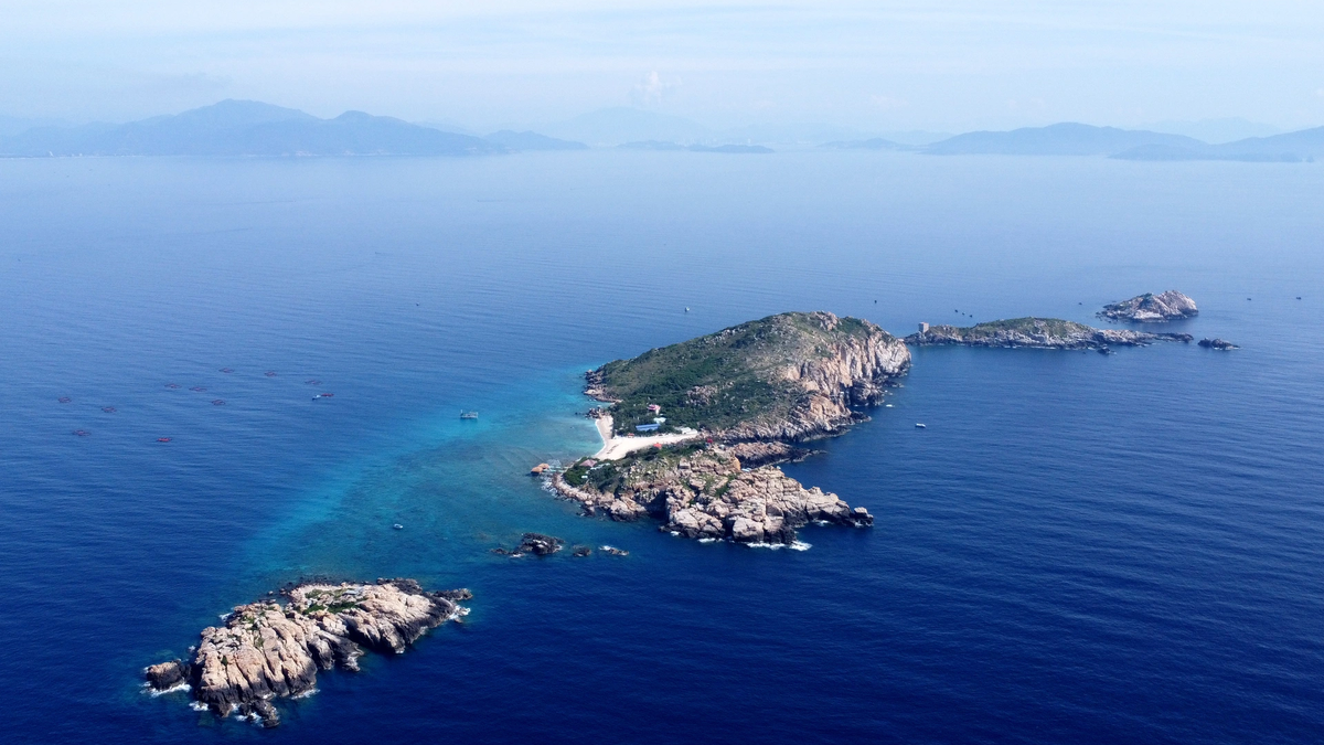
(QBĐT) - I don't know how many rivers in Vietnam from South to North have names that mean "dragon". I tried to remember through geography lessons and travel trips that there is only one river running along the Vietnam-Laos border to the South, flowing into nine mouths in the Southern region, which has a long-standing familiar name, Cuu Long Giang. However, there are countless lands named "dragon" (long), and rivers named "dragon" are very rare. Yet, my small hometown, Quang Ninh, has the Long Dai River, winding through the Giang Man range of the Truong Son range, flowing into the Kien Giang River to join the large Nhat Le River.
One thing to note is that there are many areas named "dragon". In Quang Ninh district, there are villages such as: Loc Long, Phuc Long, Nam Long area, Long Dai village. Quang Trach district has Phan Long village... Some village names associated with "dragon" have not found the origin and suitable explanation for people to accept, but Long Dai village is the most recognizable. Because the village name is closely associated with the river name.
In fact, Long Dai River has many other names. That is Dai Giang, that is Nguon Cooc. So Dai Giang, Nguon Cooc, Long Dai are just to refer to Long Dai River. Dai Giang is called because this is the largest and most magnificent river flowing through the majestic Truong Son, and Cooc Source is called because in this land there are two rivers. Folklore believes that Cooc Dai Giang is the main river and Tram Kien Giang is the secondary river.
Someone has said figuratively that the Long Dai River is a fierce and raging husband river, and the Kien Giang River is a gentle and peaceful wife river. Both of these rivers originate from a mountain of Truong Son and flow towards it. The Tram source flows east, when it passes An Ma mountain, it flows downstream, the gentle flow embraces the vast flat fields of "two districts" through Hac Hai lagoon, then widens the stream for another 4km to reach the river junction called Long Dai junction to join Nhat Le river.
As for Nguon Cooc, or Long Dai, from its starting point, it meanders westward along the terrain of the Giang Man range, creating many dangerous rapids and waterfalls. Unlike Kien Giang, Long Dai does not pass through flat terrain. When it reaches Kim Sen, the river widens, the water becomes calmer, runs around Long Dai village, then gathers water at the junction, merges into Kien Giang, so that Nhat Le is responsible for carrying water to the ocean.
Once again, with pride, the name of Long Dai village coincides with the name of the river, which is very meaningful. Long Dai village before the resistance war against the French belonged to Truong Ninh commune. After Truong Ninh was divided into two communes, Xuan Ninh commune and Hien Ninh commune, Long Dai village belonged to Hien Ninh commune. The unique thing about the village's location is that it is in a commune that is not connected by land, but is separated as a separate block. In the past, when going back and forth, you had to cross a ferry, but today there is a bridge connecting it.
Long Dai River has been a vital waterway for people from the lowlands to the highlands and for people from the highlands to the lowlands to develop timber and stone exploitation, or to transport goods according to the needs of people from both regions. During the resistance war against the French, Long Dai River embraced resistance villages in the war zone.
 |
Along the Long Dai river basin, after the "Ha Son" campaign on July 15, 1949 (75 years ago), the headquarters of Quang Binh province moved from Minh Cam and Tuyen Hoa to Ben Tiem, Da Mot, Nuoc Dang, Lui, Ha Oi... to lead the resistance war until victory, advancing to take over Dong Hoi town in 1954.
Long Dai during the resistance war against the US was also a hot spot for coordinate bombs from all types of US planes, day and night, continuously raining down in order to cut off the last ferry route to transport troops, weapons, and food to the southern battlefield. To keep the Long Dai ferry route open, many army units and youth volunteer units stayed to keep the ferry route open. Here, companies of soldiers heroically sacrificed themselves. There is an idiom “Long Dai-long dau” that also appeared at this fierce ferry terminal, and many people still mention it.
In the reflection of the river, the small and dear green village of Long Dai embraces the river with even more affection. Since ancient times, the village has had the same name as the river, and many generations have followed in its footsteps. Many villagers have been born, grown up, spread their wings and traveled here and there, still keeping the pride of the name Long Dai village.
The Long Dai riverbank embraces Long Dai village. The stone embankments have been firmly reinforced to keep the banks from eroding during the flood season. On the soft curves of the river, a concrete road has also been expanded, creating a truly charming landscape for the village. The rows of green trees naturally shade the road, creating a beauty that few rural areas can match.
The village is near the river, embraced by the river like that, but it is a dead land, lacking water for crops all year round. More than fifteen years ago, Quang Ninh district had a project to build Hoc Tre lake but the amount of water brought back was not enough to irrigate the crops all year round. Once when visiting an old friend, when passing through the fields, I saw some green rice fields, some with weeds growing. Realizing the strange thing, I asked Van Hoang:
- Van Hoang! Why is there such a rare land here but there are abandoned rice fields?
Van Hoang looked at me and smiled innocently:
- It's not abandoned, brother. Here, the fields don't have enough water to irrigate, so we have to divide the work like that. This year, owner of field A works, owner of field B rests. The next year, it's the opposite. This has become a normal thing for Long Dai people.
Hearing Van Hoang speak, I felt strange and shocked. I knew that the water source of Rao Da Lake had not only been enough to irrigate the fields, but also overflowed into Kien Giang River. That was why they had to endure such a situation. The irrigation water had crossed Kien Giang River to the two communes of Ham Ninh, Duy Ninh, and Long Dai, which should have been like this for a long time! After nearly 50 years of war, in the process of economic development, Long Dai village, which had been embraced by the river for generations, was still lacking water to irrigate the fields, which was strange. Perhaps this was a rare event in the village's current context.
I think, Long Dai village is located on the river with two parallel bridges, a road bridge and a railway bridge. So how can there not be a Rao Da water pipeline to the fields of Long Dai village. A village in harmony with the river, lovingly embracing the river for thousands of years, the village name is the same as the river. Entering the year of Giap Thin, which is also "dragon", also "long", I feel more deeply the land of the countryside, although narrow and isolated, seemingly lonely but very affectionate with the whole country when mentioning the two words Long Dai.
Notes by Van Tang
Source
![[INFOGRAPHIC] Open-back headphones, look like a... pill](https://vphoto.vietnam.vn/thumb/1200x675/vietnam/resource/IMAGE/2025/7/16/cd63f007ad404018aa504c1009ce19ba)


Comment (0)