
 |
| Forecast map of storm No. 1's trajectory on the morning of June 12, 2025 (Source: National Center for Hydro-Meteorological Forecasting). |
The rain was concentrated with the highest intensity from 11pm to 1am with the highest rainfall in 1 hour at Hoa Hai being 88mm, Hoa Cuong Nam 85.4mm, Suoi Luong 85.2mm, Suoi Da 76.4mm, Thac Gian lake 76mm, Hoa Son 75.8mm, Hoa Phuoc 73.2mm, Hoa Phat 72.6mm, Phan Lang canal (Nguyen Dinh Tuu street) 70.4mm...
The water level at some automatic flood warning towers is quite deep, such as: Hoa Khanh Nam (Me Suot Street) nearly 1m; Group 53, Hoa Khe Ward (Huynh Ngoc Hue - Tran Xuan Le Street) nearly 0.9m; Group 73, An Khe Ward nearly 0.9m; Phan Dang Luu Street nearly 0.5m; Phan Dang Luu - Le Thanh Nghi intersection nearly 0.5m; Tan Da Street (Thac Gian Lake shore) 0.53m; Yen The Street nearly 0.7m; Nui Thanh - Tieu La intersection more than 0.5m; Group 8, Thanh Khe Tay Ward more than 0.5m; Hoa Thuan Tay Ward Cultural House 0.65m; Nguyen Don Tiet - Hai Ho corner 0.53m...
 |
| Workers clean the streets and clear drainage after the water receded in the early morning of June 12. Photo: HOANG HIEP |
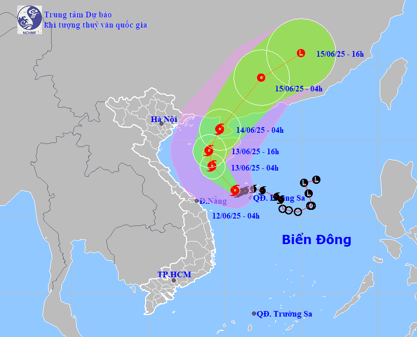
According to the National Center for Hydro-Meteorological Forecasting, early this morning, the center of storm No. 1 was located just west of Hoang Sa archipelago with the strongest wind at level 8-9, gusting to level 11; the storm moved west-northwest at a speed of 10-15km/hour.
Forecast at 4:00 a.m. on June 13, the center of the storm is at about 18.3 degrees north latitude, 109.2 degrees east longitude, south of Hainan Island with the strongest wind at level 10, gusting to level 13 and moving northwest at a speed of about 10km/hour.
Due to the impact of the storm, the northwestern area of the East Sea (including Hoang Sa archipelago) and offshore provinces and cities from Quang Tri to Quang Ngai have strong winds of level 6-8, near the storm center level 9-10, gusting to level 13; waves 3-5m high, near the storm center 4-6m, very rough seas.
From the night of June 12, the Gulf of Tonkin will have strong winds of level 6-7, near the storm center of level 8-9, gusts of level 11, waves 2-4m high.
Boats in the above areas should avoid operations, high risk of tornadoes, big waves, gusts of wind.
From June 12 to 13, the Central Central region will continue to have heavy to very heavy rain with common rainfall of 100-200mm, some places over 350mm; Ha Tinh province and the northern Central Highlands will have moderate to heavy rain with rainfall of 30-80mm, some places over 150mm.
Risk of rainfall greater than 200mm in 6 hours; risk of flash floods, landslides in mountainous areas, urban flooding in low-lying areas. During thunderstorms, there is a possibility of tornadoes, lightning, and strong gusts of wind.
From June 14, heavy rain tends to decrease.
HOANG HIEP
Source: https://baodanang.vn/xa-hoi/202506/trung-trung-bo-con-mua-to-den-rat-to-4008558/


Comment (0)