

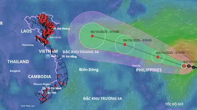
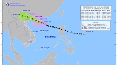
The National Center for Hydro-Meteorological Forecasting said that at about 4:00 a.m. on August 19, the center of the tropical depression was at about 21.2 degrees North latitude; 107.4 degrees East longitude, on the coastal area of Quang Ninh - Hai Phong . The strongest wind near the center of the tropical depression was at level 6, gusting to level 8; moving in the Northwest direction at a speed of about 15 km/hour towards the mainland of Quang Ninh.
Forecast by 4:00 p.m. on August 19, the center of the tropical depression will be at about 22.8 degrees North latitude; 107.2 degrees East longitude, in the Guangxi region (China); wind speed less than level 6; moving north at a speed of about 10 - 15 km/hour and weakening into a low pressure area.
Due to the influence of the tropical depression, the Gulf of Tonkin (including the special zones of Bach Long Vi, Cat Hai, Co To and Van Don) has thunderstorms and strong winds of level 6 - 7, gusts of level 9, waves 2 - 3.5m high, and rough seas. Ships operating in the above-mentioned dangerous areas are likely to be affected by thunderstorms, whirlwinds, strong winds, and large waves.
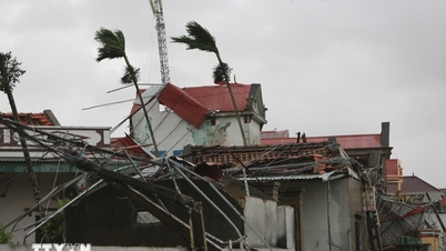
On land, from the evening and night of August 18 to the night of August 19, the Northeast and Thanh Hoa will have moderate rain, heavy rain and thunderstorms with common rainfall of 50 - 150mm, locally very heavy rain over 300mm. During thunderstorms, there is a possibility of tornadoes, lightning, hail and strong gusts of wind.
In the evening and night of August 18, in Nghe An , there will be moderate rain, heavy rain and thunderstorms with common rainfall of 20 - 40mm, locally very heavy rain over 80mm.
In addition, in the evening and night of August 18, the Northwest region, from Ha Tinh to Da Nang and the Central Highlands, will have scattered showers and thunderstorms, with some places experiencing heavy rain with rainfall of 15-30mm, and some places experiencing over 80mm.
The hydrometeorological agency said that from August 20, heavy rain in various areas will gradually decrease.
In response to the above weather developments, Mr. Mai Van Khiem, Director of the National Center for Hydro-Meteorological Forecasting, warned that thunderstorms, tornadoes, lightning, and strong gusts of wind pose a potential risk to people's lives and property. Tornadoes often occur with strong thunderstorms. Heavy rain can cause flooding in low-lying roads, urban areas, etc. When there are warnings of thunderstorms, people should take shelter in safe places in solidly built structures.
To proactively respond, authorities and people in affected areas need to regularly monitor forecast and warning information on the website of the National Center for Hydro-Meteorological Forecasting at nchmf.gov.vn, provincial, municipal and regional Hydro-Meteorological Stations, and regularly update the latest hydro-meteorological forecast information on the official mass media of the Central and local levels.
Source: https://baolaocai.vn/ap-thap-nhiet-doi-se-vao-dat-lien-quang-ninh-trong-sang-198-post879929.html
![[Photo] General Secretary To Lam attends the 8th Congress of the Central Public Security Party Committee](https://vphoto.vietnam.vn/thumb/1200x675/vietnam/resource/IMAGE/2025/10/4/79fadf490f674dc483794f2d955f6045)
![[Photo] Solemn opening of the 8th Congress of the Central Public Security Party Committee, term 2025-2030](https://vphoto.vietnam.vn/thumb/1200x675/vietnam/resource/IMAGE/2025/10/4/f3b00fb779f44979809441a4dac5c7df)
![[Photo] Bustling Mid-Autumn Festival at the Museum of Ethnology](https://vphoto.vietnam.vn/thumb/1200x675/vietnam/resource/IMAGE/2025/10/4/da8d5927734d4ca58e3eced14bc435a3)


![[VIDEO] Summary of Petrovietnam's 50th Anniversary Ceremony](https://vphoto.vietnam.vn/thumb/402x226/vietnam/resource/IMAGE/2025/10/4/abe133bdb8114793a16d4fe3e5bd0f12)

![[VIDEO] GENERAL SECRETARY TO LAM AWARDS PETROVIETNAM 8 GOLDEN WORDS: "PIONEER - EXCELLENT - SUSTAINABLE - GLOBAL"](https://vphoto.vietnam.vn/thumb/402x226/vietnam/resource/IMAGE/2025/7/23/c2fdb48863e846cfa9fb8e6ea9cf44e7)


Comment (0)