
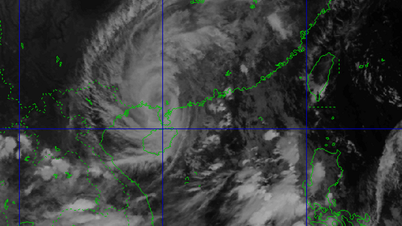
At noon on September 18, the tropical depression in the East Sea intensified into storm No. 8, internationally named Mitag. At 1 p.m., the center of the storm was in the northeast of the North East Sea with strong winds of level 8, gusts of level 10, moving northwest at a speed of 15-20 km/hour.
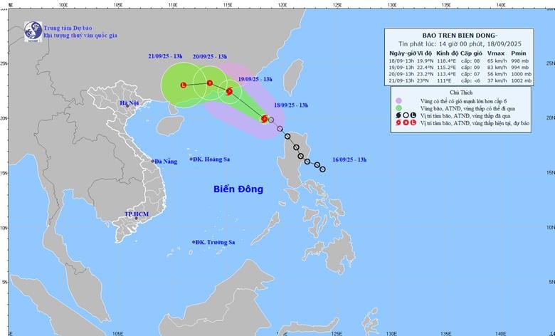 |
According to the National Center for Hydro-Meteorological Forecasting, at 1:00 p.m. this afternoon, the eye of the storm was located at approximately 19.9 degrees North latitude; 118.4 degrees East longitude, in the northeastern sea area of the North East Sea. The strongest wind near the eye of the storm reached level 8 (62-74 km/h), gusting to level 10. The storm moved northwest at a speed of 15-20 km/h.
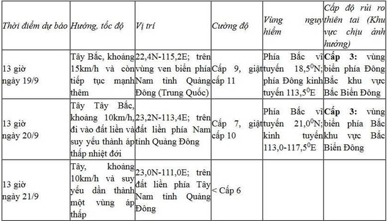
Forecast of tropical depression/storm development (in the next 24 to 72 hours):
 |
At sea, the northeastern area of the North East Sea has strong winds of level 6-7, gusting to level 9. The area near the storm's center has strong winds of level 8-9, gusting to level 11; waves are 3-5m high, and the sea is very rough.
Vessels operating in the danger zone are subject to strong winds, large waves, thunderstorms and tornadoes.
According to PV/VOV.VN
Source: https://baovinhlong.com.vn/thoi-su/202509/ap-thap-nhiet-doi-tren-bien-dong-da-manh-thanh-bao-so-8-mitag-tu-trua-nay-189-08a0500/

![[Photo] Closing of the 1st Congress of Party Delegates of Central Party Agencies](https://vphoto.vietnam.vn/thumb/1200x675/vietnam/resource/IMAGE/2025/9/24/b419f67738854f85bad6dbefa40f3040)


![[Photo] Editor-in-Chief of Nhan Dan Newspaper Le Quoc Minh received the working delegation of Pasaxon Newspaper](https://vphoto.vietnam.vn/thumb/1200x675/vietnam/resource/IMAGE/2025/9/23/da79369d8d2849318c3fe8e792f4ce16)


![[Photo] Solemn opening of the 1st Congress of Party Delegates of Central Party Agencies](https://vphoto.vietnam.vn/thumb/402x226/vietnam/resource/IMAGE/2025/9/24/82a89e250d4d43cbb6fcb312f21c5dd4)


Comment (0)