

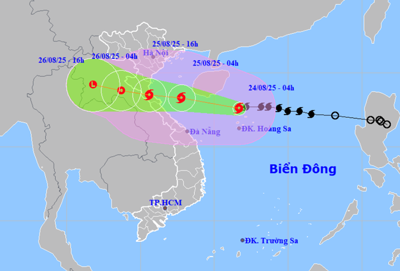
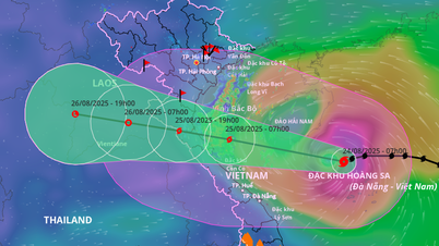
The Hydrometeorological Agency forecasts that tonight and early tomorrow morning, storm No. 5 will directly affect the mainland areas of the provinces from Thanh Hoa to Quang Tri . By noon and early afternoon of August 25, the storm will make landfall.
 |
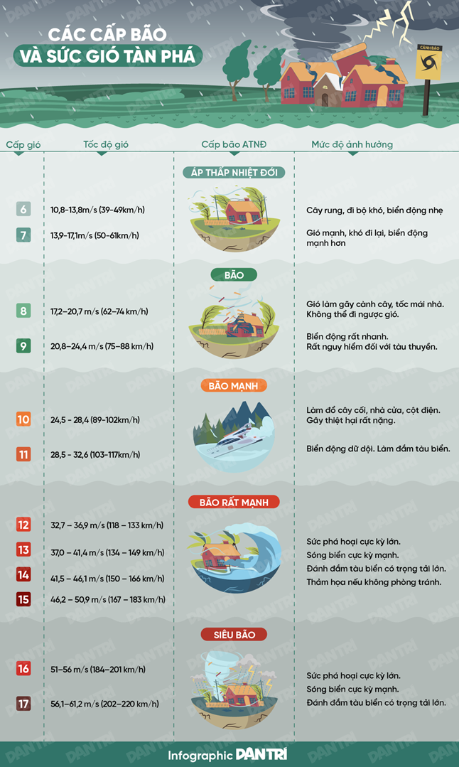
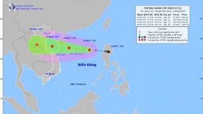
| Storm No. 5 still has the potential to increase in intensity, possibly reaching level 13-14, gusting to 15-16 (Photo: NCHMF). |
The National Center for Hydro-Meteorological Forecasting said that at 5am on August 24, storm No. 5 (international name Kajiki) had increased to level 12, gusting to 15, about 620km from Nghe An and Ha Tinh . The storm moved quickly, traveling about 20km per hour.
It is forecasted that in the next 12-24 hours, the storm will still have the potential to increase in intensity, possibly reaching level 13-14, gusting to 15-16.
The hydrometeorological agency forecasts that tonight and early tomorrow morning, storms will directly affect the mainland areas of the provinces from Thanh Hoa to Quang Tri.
By noon and early afternoon of August 25, the storm will make landfall in the provinces from Nghe An to Quang Binh, causing strong winds near the storm's eye at level 10-12, gusts at level 14-15, heavy rain of 200-400mm, in some places over 700mm, according to the meteorological and hydrological agency.
Due to the influence of the storm, the western sea area of the North East Sea (including Hoang Sa special zone) has strong winds of level 8-10, the area near the storm's eye has winds of level 11-13, gusts of level 15, waves 5-7m high, the area near the storm's eye has waves of 7-9m, and the sea is very rough.
From noon and afternoon today, the sea area from Thanh Hoa to Hue (including Hon Ngu island, Con Co special zone) will have winds gradually increasing to level 6-8, then increasing to level 9-10, the area near the storm's center will have winds of level 11-13, gusting to level 15, waves 4-6m high, the area near the center will have waves of 7-9m, the sea will be very rough.
From this afternoon, the northern area of Bac Bo Gulf (including Cat Hai, Co To, Van Don special economic zones) will have winds gradually increasing to level 6-7, gusting to level 9; the southern area of Bac Bo Gulf (including Bach Long Vi special economic zone) will have strong winds of level 8, gusting to level 10, waves 2-4m high, rough seas.
Mr. Mai Van Khiem, Director of the National Center for Hydro-Meteorological Forecasting, said that the weather at sea and in coastal areas during the storm is extremely dangerous, unsafe for any vehicles or structures operating in the danger zone.
On land, from the night of August 24, on land from Thanh Hoa to Quang Tri, winds will gradually increase to level 7-9, near the storm center level 10-12, gusting to level 14-15; coastal areas from Quang Ninh to Ninh Binh will gradually increase to level 6-7, gusting to level 8.
From the night of August 24 to the end of August 26, the Northern Delta, Southern Phu Tho and from Thanh Hoa to Hue are likely to experience widespread heavy rain with rainfall ranging from 100-150mm, locally over 250mm; the Thanh Hoa to Northern Quang Tri area will experience heavy to very heavy rain with rainfall ranging from 200-400mm, locally over 700mm.
Around August 25-26, Hanoi and Da Nang will have moderate to heavy rain and thunderstorms; Ho Chi Minh City will have rain, showers and thunderstorms in the late afternoon and evening. During thunderstorms, be on guard against the risk of tornadoes and strong gusts of wind.
Around August 25-27, the Upper and Central Laos regions are likely to experience heavy rain with common rainfall of 100-250mm, and in some places in the Central Laos region, over 500mm.
Mr. Khiem said that according to the forecast of the National Center for Hydro-Meteorological Forecasting and international centers, storm No. 5 could reach level 12-13, gusting 15-16 in the Gulf of Tonkin and the sea from Quang Tri to Hue. In some cases, some models even predict the storm will be stronger.
According to the expert, forecasting centers assessed that the danger level of storm No. 5 is no less than that of storm Yagi in 2024 in terms of strong winds and at least equal to, or possibly even stronger than, storm No. 10 (storm Doksuri) in 2017 - this storm has a similar path and area of influence.
Experts predict that the danger of this storm is not only due to strong winds but also due to the combined impact of many natural disasters such as very strong winds, extremely heavy rains, the risk of widespread flooding, flash floods and landslides. Storm No. 5 poses a comprehensive threat from the sea, the plains to the mountainous areas.
Faced with that situation, the National Center for Hydro-Meteorological Forecasting has raised the disaster risk warning level to level 4 (very high level) for coastal areas from Thanh Hoa to Hue and mainland provinces from Thanh Hoa to Quang Tri (most likely the focus is the Ha Tinh and Northern Quang Tri areas).
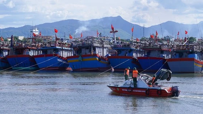
The hydrometeorological agency warns people to urgently take precautions, reinforce their houses, evacuate when required, and absolutely not go out to sea at this time.
 |
According to Bach AnDan Tri
Source: https://baovinhlong.com.vn/tin-moi/202508/bao-kajiki-tang-len-cap-12-co-the-dat-cap-13-14-giat-cap-16-5070b11/


![[Photo] Phu Quoc: Propagating IUU prevention and control to the people](https://vphoto.vietnam.vn/thumb/1200x675/vietnam/resource/IMAGE/2025/8/24/f32e51cca8bf4ebc9899accf59353d90)
![[Photo] Party and State leaders meet with representatives of all walks of life](https://vphoto.vietnam.vn/thumb/1200x675/vietnam/resource/IMAGE/2025/8/24/66adc175d6ec402d90093f0a6764225b)


Comment (0)