
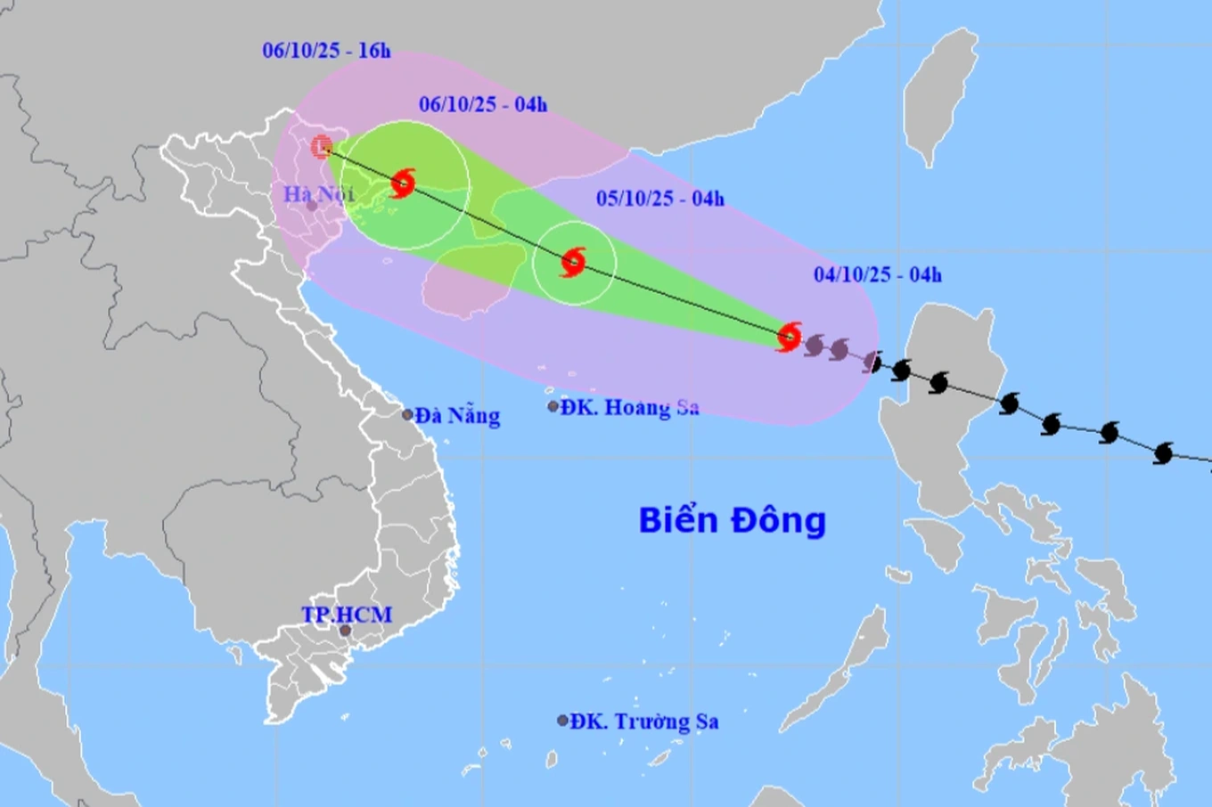
The National Center for Hydro-Meteorological Forecasting said that on the morning of October 4, storm Matmo (storm No. 11) had strengthened to level 11 (103-117km/h), gusting to level 14, and was active in the eastern sea area of the North East Sea, about 570km east-northeast of Hoang Sa special zone.
The storm is forecast to move west-northwest at a speed of about 25km/h.
According to forecasts, in the early morning of October 5, the storm will strengthen to level 13, gusting to level 16 in the North East Sea, about 130km east of Leizhou Peninsula (China).
The meteorological agency said that around the morning of October 6, the storm entered the eastern sea area of the Northern Gulf of Tonkin. The storm's intensity has now decreased to level 10, gusting to level 13 on the northeastern coastal area of Quang Ninh province.
It is forecasted that on the afternoon of October 6, the storm will make landfall in the Northeast region and gradually weaken into a tropical depression, then a low pressure area.
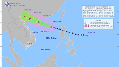
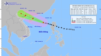
Forecast of the movement of the tropical depression (Photo: NCHMF).
Due to the storm's influence, the North East Sea area has strong winds of level 8-10, the area near the storm's eye has winds of level 11-13, gusts of level 16, waves 4-6m high, the area near the storm's eye has waves of 6-8m high, and the sea is very rough.
From the afternoon of October 5, the sea area east of the Northern Gulf of Tonkin (including Bach Long Vi special zone) has winds gradually increasing to level 6-7, then increasing to level 8-9.
From the evening of October 5, the Northern Gulf of Tonkin area (including Bach Long Vi, Van Don, Co To, Cat Hai and Hon Dau islands) will have winds gradually increasing to level 8-9, waves 2-4m high, the area near the storm's center will have winds of level 10-11, gusts of level 14, waves 3-5m high, and very rough seas.
Coastal areas and islands in Quang Ninh - Hai Phong provinces are forecast to have storm surges of 0.4-0.6m. Flooding should be prevented in low-lying coastal areas and river mouths due to surges and big waves from the afternoon and evening of October 5.
The Hydrometeorological Agency said that from the night of October 5, on land from Quang Ninh to Ninh Binh, winds will gradually increase to level 6-8, near the storm's eye, level 9-10; in the inland areas of the Northeast, winds will be strong at level 6, in some places level 7, gusting to level 8-9.
From the night of October 5 to the end of the night of October 7, the Northern region, Thanh Hoa and Nghe An will have heavy to very heavy rain with common rainfall of 100-200mm, locally over 300mm; in the mountainous and midland regions of the North, common rainfall is from 150-250mm, locally over 400mm.
The hydrometeorological agency warns of the risk of heavy rain over 200mm/3 hours.
Storm Matmo is also forecast to cause heavy rain in Hanoi with average rainfall of 100-200mm, the rain will concentrate in the early morning of October 6 and last until the morning of October 7.
With heavy rain, the hydrometeorological agency warned of a flood lasting from October 6 to October 9 on rivers in the Northern region, Thanh Hoa - Nghe An.
"Natural disaster upon natural disaster"
At the meeting on the afternoon of October 3, Deputy Prime Minister Tran Hong Ha emphasized that storm Matmo is extremely dangerous, a "natural disaster on top of natural disaster". Localities need to be aware of the extremely complicated nature of the situation to take timely measures and not be subjective.
Government leaders requested forecasting agencies to continue updating and combining international forecasts with practical experience, preparing for the situation of "storm on storm, multiple natural disasters".
Because after storm No. 10, many river and sea dikes are still weak, the Deputy Prime Minister requested that within two days before the storm makes landfall, localities must mobilize forces to handle the situation immediately.
The Deputy Prime Minister assessed that the Northern midland mountainous region is an especially dangerous area, with many places still recovering from damage, search and rescue operations still underway, and now facing heavy rain. Therefore, the hydrometeorological agency needs to accurately delineate the heavy rain area, calculating the amount of water flowing from upstream.
Local authorities, police and military must resolutely enforce evacuation in case people do not comply, and at the same time ensure the safety of property and boats to reassure people, as requested by the Deputy Prime Minister.
Dantri.com.vn
Source: https://dantri.com.vn/thoi-su/bao-matmo-tang-cap-nhanh-nhung-khu-vuc-nao-bi-anh-huong-20251004060541295.htm
![[Infographic] Notable numbers after 3 months of "reorganizing the country"](https://vphoto.vietnam.vn/thumb/1200x675/vietnam/resource/IMAGE/2025/10/4/ce8bb72c722348e09e942d04f0dd9729)


![[Photo] General Secretary To Lam attends the 8th Congress of the Central Public Security Party Committee](https://vphoto.vietnam.vn/thumb/1200x675/vietnam/resource/IMAGE/2025/10/4/79fadf490f674dc483794f2d955f6045)


![[Photo] Prime Minister Pham Minh Chinh chairs meeting to deploy overcoming consequences of storm No. 10](https://vphoto.vietnam.vn/thumb/1200x675/vietnam/resource/IMAGE/2025/10/3/544f420dcc844463898fcbef46247d16)
![[Photo] Students of Binh Minh Primary School enjoy the full moon festival, receiving the joys of childhood](https://vphoto.vietnam.vn/thumb/1200x675/vietnam/resource/IMAGE/2025/10/3/8cf8abef22fe4471be400a818912cb85)


Comment (0)