

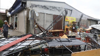
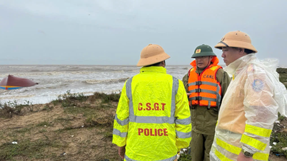
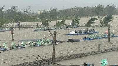
Accordingly, the sea area of Hoang Sa archipelago has strong winds of level 6-7, then increasing to level 8-9, the area near the storm's eye has winds of level 11-13, gusting to level 16; waves are 6-8m high, the area near the storm's eye has waves of 8-10m high, the sea is very rough.
From noon and afternoon of September 27, the sea area of Da Nang city (including Hoang Sa special zone) began to see big waves with wave heights of 2-4m, the area near the storm center had waves 4-6m high.
From the evening and night of September 27, the sea area of Da Nang city will have strong winds of level 6-7, gusts of level 8-9, waves of 5-7m high, and rough seas. From the morning of September 28, the winds will increase to level 8-9, the area near the storm's center will have strong winds of level 11-13, gusts of level 15-16.
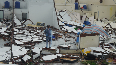
Wind intensity on September 28 on the mainland of Da Nang city also depends on the direction of movement of storm No. 10. In case the storm moves close to the coastal waters of Da Nang, it will have a worse impact on the mainland coastal areas of the city.
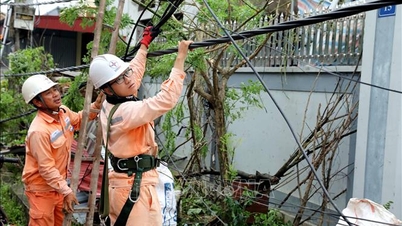
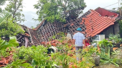
In addition, due to the influence of storm No. 10, from the evening and night of September 27 to September 28, in communes and wards in Da Nang city, there is a possibility of moderate rain, scattered heavy rain and thunderstorms, and very heavy rain in some places.
The Central Hydrometeorological Station assessed that the total rainfall for the entire period was generally from 100 - 200mm, in some places over 300mm; in particular, in communes and wards in the mountainous area northwest of the city, it was generally 60 - 120mm, in some places over 150mm.
The time of greatest intensity of rain is likely to be from early morning until the end of September 28.
Heavy rains pose a high risk of flash floods and landslides in mountainous areas and flooding in urban and low-lying areas.

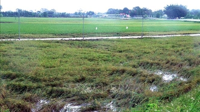
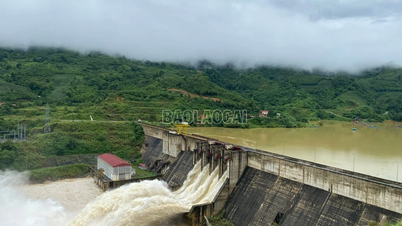
From September 28 to 29, there is a possibility of a small flood on the rivers in Da Nang city. Specifically, the flood peak on Vu Gia river is at alert level (BĐ) to BĐ 2; Han river at Cam Le is at level above or below BĐ 1; Thu Bon river is at level above or below BĐ 1; Tam Ky river is at approximately BĐ 1.
High risk of flooding in low-lying areas, urban areas, especially the central area of Da Nang city.
However, the development of storm No. 10 is still complicated, especially since the storm is moving very quickly, so it is necessary to continue monitoring and continuously updating the storm's developments in the coming time.
Source: https://baodanang.vn/bao-so-10-di-chuyen-rat-nhanh-huong-vao-vung-bien-khu-vuc-trung-bo-3303787.html

![[Photo] National Assembly Chairman Tran Thanh Man chairs the 8th Conference of full-time National Assembly deputies](https://vphoto.vietnam.vn/thumb/1200x675/vietnam/resource/IMAGE/2025/9/29/2c21459bc38d44ffaacd679ab9a0477c)
![[Photo] General Secretary To Lam receives US Ambassador to Vietnam Marc Knapper](https://vphoto.vietnam.vn/thumb/1200x675/vietnam/resource/IMAGE/2025/9/29/c8fd0761aa184da7814aee57d87c49b3)
![[Photo] General Secretary To Lam chairs the meeting of the Central Steering Committee on preventing and combating corruption, waste and negativity](https://vphoto.vietnam.vn/thumb/1200x675/vietnam/resource/IMAGE/2025/9/29/fb2a8712315d4213a16322588c57b975)
![[Photo] General Secretary To Lam attends the ceremony to celebrate the 80th anniversary of the post and telecommunications sector and the 66th anniversary of the science and technology sector.](https://vphoto.vietnam.vn/thumb/1200x675/vietnam/resource/IMAGE/2025/9/29/8e86b39b8fe44121a2b14a031f4cef46)
![[Photo] Many streets in Hanoi were flooded due to the effects of storm Bualoi](https://vphoto.vietnam.vn/thumb/1200x675/vietnam/resource/IMAGE/2025/9/29/18b658aa0fa2495c927ade4bbe0096df)


Comment (0)