
On the afternoon of July 22, the National Center for Hydro-Meteorological Forecasting said that in the past 3 hours, storm No. 3 (storm WIPHA) has moved little; at Hon Dau ( Hai Phong ) at 4:00 p.m., strong winds of level 8, gusting to level 10 were recorded; Uong Bi (Quang Ninh) level 7, gusting to level 8; Van Ly (Ninh Binh) level 8, gusting to level 10; Ba Lat (Hung Yen) level 7, gusting to level 9;...
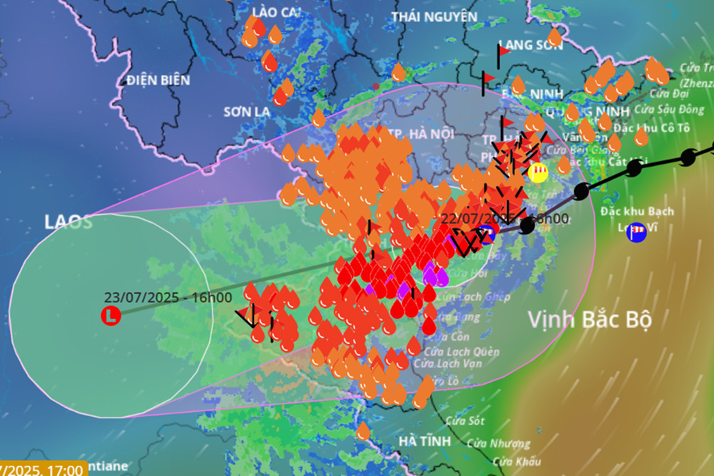
At 4 p.m., the center of storm No. 3 was located on the mainland of Ninh Binh - Thanh Hoa provinces. The strongest wind near the center of the storm was level 8 (62-74 km/h), gusting to level 10; moving west at a speed of 10-15 km/h.
In the next 24 hours, the storm will continue to move West Southwest, 10-15km/h and weaken into a tropical depression, then continue to weaken into a low pressure area over Upper Laos.
Due to the influence of storm No. 3, this evening and tonight, the Bac Bo Gulf area (including the special zones of Bach Long Vi, Co To, Van Don, Cat Hai, Hon Dau and Hon Ngu islands) will have strong winds of level 6-7, near the storm center of level 8, gusting to level 10; waves 2-4m high; rough seas.
The meteorological agency continues to warn that the weather at sea and in coastal areas during the storm is extremely dangerous and unsafe for any vehicles or structures operating in the dangerous area such as: cruise ships, passenger ships, transport ships, cages, rafts, aquaculture areas, dykes, embankments, coastal routes. Vehicles are at high risk of capsizing, destruction, and flooding due to strong winds, storms, whirlwinds, and large waves.
At the same time, on land, coastal areas from Quang Ninh to Nghe An have strong winds of level 6-7, near the storm center level 8, gusting to level 10; inland areas of the provinces and cities of Hai Phong, Hung Yen, Bac Ninh, Hanoi, Ninh Binh and Thanh Hoa have gusts of level 6-8. Level 8 winds can break tree branches, blow off roofs, causing damage to houses.
Heavy rain continues in many places
Last night and today (July 22), in the Northern Delta region, the area from Thanh Hoa to Ha Tinh had moderate rain, heavy rain and thunderstorms, locally very heavy rain; especially in Hung Yen, Ninh Binh, Thanh Hoa, Nghe An, there was heavy to very heavy rain.
Rainfall from 7pm to 3pm on July 22 was over 250mm in some places such as: Dong Giao station (Ninh Binh) 253.8mm, Sam Son station (Thanh Hoa) 398.6mm, Nhu Xuan station (Thanh Hoa) 374.0mm, Chau Nga station (Nghe An) 316.8mm,...
From this evening to the morning of July 23, Thanh Hoa, Nghe An, southern Phu Tho and Son La will continue to experience heavy to very heavy rain with common rainfall of 40-100mm, locally over 200mm. Warning of risk of heavy rain (>150mm/3 hours).
In addition, from this evening to the afternoon of July 23, other places in the North and Ha Tinh will have rain, moderate rain, locally heavy rain with rainfall from 20-40mm, locally over 100mm.
This evening and tonight, the Central Highlands and the South will also have scattered showers and thunderstorms, locally heavy rain with rainfall of 10-30mm, locally over 70mm.
Notably, from July 24-25, the Northern region and from Thanh Hoa and Nghe An are likely to continue to have moderate rain, heavy rain and thunderstorms, with some places having very heavy rain.
15:45, July 22 : Currently, at coastal stations and coastal estuaries, the water level has risen from 0.5-0.8m; at Ba Lat hydrological station (Hung Yen), the water level has risen 0.8m, the highest water level at 14:50 was 2.97m - exceeding the historical level of 2017: 0.26m; at Dong Quy hydrological station (Hung Yen), the water level has risen 0.6m, the water level is 2.44m and is continuing to rise.
Due to the impact of storm No. 3 causing sea levels to rise, in addition, the coastal area of Hung Yen province is experiencing strong southeast winds, pushing water from the sea to the shore.
Source: https://baohaiphongplus.vn/bao-so-3-van-chua-tan-khu-vuc-nao-con-mua-rat-lon-416993.html


Comment (0)