

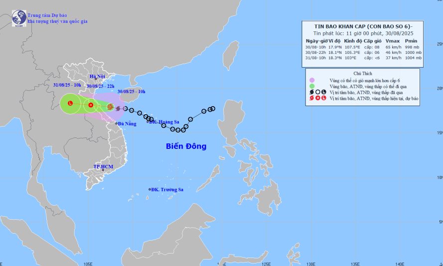
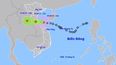
Forecast map of storm trajectory and intensity at 11:00 on August 30, 2025.
At 10:00 a.m. on August 30, the center of the storm was at about 17.9 degrees North latitude; 107.5 degrees East longitude, in the Ha Tinh - Quang Tri sea area, about 120km east of the northern Quang Tri area. The strongest wind near the center of the storm was level 8 (62-74km/h), gusting to level 10-11. Moving in the West Northwest direction at a speed of 20-25km/h.
Due to the influence of storm No. 6, at Bach Long Vi station (Hai Phong) there were strong winds of level 7, gusting to level 9; Co To station (Quang Ninh) had strong winds of level 6, sometimes level 7, gusting to level 8; Con Co station (Quang Tri) had strong winds of level 6, gusting to level 8;... In the provinces from Nghe An to Da Nang , there was heavy rain, in some places very heavy rain over 170mm.
Note: Storm No. 6 causes strong winds of level 8, gusting to level 10-11. This wind level can break tree branches, blow roofs off houses, causing damage to houses. Do not go against the wind. The sea is very rough, very dangerous for boats and rafts. Absolutely do not be subjective.
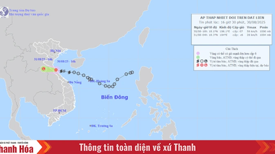
At 10:00 p.m. on August 30, the storm center was at 18.1 degrees North latitude, 105.3 degrees East longitude, moving in the West Northwest direction, about 20km/h, entering the mainland of Ha Tinh - Northern Quang Tri provinces and gradually weakening into a tropical depression.
The sea area from Thanh Hoa to Hue (including Hon Ngu island and Con Co special zone) has stormy rain, strong winds of level 6-7, near the storm's eye strong winds of level 8, gusts of level 10; waves 2.0-4.0m high, near the storm's eye 3.0-5.0m high, rough seas.
The northern sea area of Bac Bo Gulf has strong winds of level 6, sometimes level 7, gusting to level 9; waves 2.0-4.0m high, rough seas. Storm surge: Coastal areas from Nghe An to Hue have water levels rising from 0.2-0.4m.
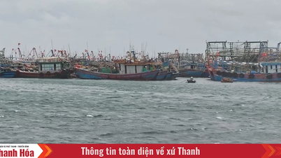
Warning: The weather at sea and in coastal areas is very dangerous and unsafe for vehicles and structures operating in dangerous areas such as: cruise ships, passenger ships, transport ships, cages, rafts, and aquaculture areas.
On land: From noon on August 30, on the mainland coastal provinces from Nghe An to Quang Tri, the wind will gradually increase to level 6, gusting to level 8; in the mainland coastal areas of Ha Tinh - Northern Quang Tri, it will be level 6-7, near the storm center, it will be level 8, gusting to level 10.
From noon on August 30 to the end of August 31, the area from Thanh Hoa to Hue City will have heavy to very heavy rain with common rainfall of 100-250mm, locally over 400mm; the midland and Northern Delta areas will have moderate to heavy rain, locally very heavy rain with common rainfall of 50-120mm, locally over 250mm.
LP
Source: https://baothanhhoa.vn/bao-so-6-cach-quang-tri-120km-cac-tinh-tu-thanh-hoa-den-hue-mua-to-260105.htm


![[Photo] People eagerly lined up to receive special publications of Nhan Dan Newspaper](https://vphoto.vietnam.vn/thumb/1200x675/vietnam/resource/IMAGE/2025/8/30/53437c4c70834dacab351b96e943ec5c)


Comment (0)