
In the next 24 hours, the storm will move in the West Northwest direction, 20-25km/h and gradually weaken. By 4am on September 25, the storm will be on the coastal area of Guangxi province (China); about 150km east of Mong Cai ( Quang Ninh ) with a strong intensity of level 11, gusting to level 13.
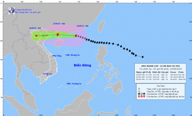
Due to the influence of the storm, the northern sea area of the North East Sea has strong winds of level 10-13, the area near the center of the super storm has winds of level 14-16, gusts over level 17, waves over 10.0m high; rough seas.
From noon today, the eastern sea area of the Northern Gulf of Tonkin (including Bach Long Vi special zone) will have winds gradually increasing to level 6-7, gusting to level 9. By tonight, the northern Gulf of Tonkin area (including Bach Long Vi special zone, Van Don, Co To, Cat Hai and Hon Dau island) will have winds gradually increasing to level 8, waves 2.0-4.0m high, the area near the storm center will have winds of level 9-11, gusting to level 13, waves 3.0-5.0m high; very rough seas.
From early morning on September 25, coastal areas from Quang Ninh to Ninh Binh will have winds gradually increasing to level 6-7, near the storm center level 8-9, gusting to level 11; inland areas in the Northeast, winds will be strong at level 5, in some places level 6, gusting to level 7-8.
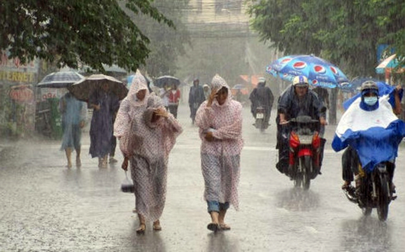
From the night of September 24 to the end of the night of September 26, the Northern region, Thanh Hoa and Nghe An will have heavy to very heavy rain with common rainfall of 100-250mm, locally over 400mm. Beware of heavy rain causing urban flooding. Heavy rain is likely to cause flooding in low-lying areas; flash floods on small rivers and streams, landslides on steep slopes.
Weather nationwide on Wednesday (September 24), Hanoi capital is cloudy, sunny during the day, showers and scattered thunderstorms at night, locally heavy to very heavy rain. North to northwest wind level 2-3. Lowest temperature 24-26 degrees. Highest temperature 33-35 degrees.
The Northwest region is cloudy, sunny during the day, with showers and thunderstorms in some places in the evening and at night. Light wind. Lowest temperature 22-25 degrees, some places below 21 degrees. Highest temperature 32-35 degrees.
Northeast region: cloudy, sunny during the day; moderate rain, heavy rain and scattered thunderstorms at night, locally very heavy rain. North to northwest wind level 2-3. Lowest temperature 22-25 degrees, mountainous areas below 22 degrees. Highest temperature 32-35 degrees.
From Thanh Hoa to Hue, it is cloudy, sunny during the day, with showers and thunderstorms in some places in the evening and at night. North to northwest wind level 2-3. Lowest temperature 24-27 degrees. Highest temperature 31-34 degrees.
South Central Coast: Cloudy, sunny during the day, scattered showers and thunderstorms in the evening and at night. West to southwest wind level 2-3. Lowest temperature 24-27 degrees. Highest temperature 31-34 degrees.
Central Highlands cloudy, scattered showers and thunderstorms, scattered showers and thunderstorms in the evening and at night, locally heavy rain. Southwest wind level 2-3. Lowest temperature 19-22 degrees. Highest temperature 25-28 degrees.
The South is cloudy with scattered showers and thunderstorms; scattered showers and thunderstorms in the afternoon and evening; the East has scattered showers and thunderstorms in the afternoon and evening, with some heavy rain in some places. Southwest wind level 3. Lowest temperature 23-26 degrees. Highest temperature 30-33 degrees.
Ho Chi Minh City is cloudy, with scattered showers and thunderstorms in the late afternoon and at night, with heavy rain in some places. Southwest wind level 3. Lowest temperature 24-26 degrees. Highest temperature 31-33 degrees.
Source: https://cand.com.vn/Xa-hoi/bao-so-9-giam-cap-ap-sat-dat-lien-mien-bac-dem-co-mua-to-i782276/
![[Infographic] Notable numbers after 3 months of "reorganizing the country"](https://vphoto.vietnam.vn/thumb/1200x675/vietnam/resource/IMAGE/2025/10/4/ce8bb72c722348e09e942d04f0dd9729)
![[Photo] General Secretary To Lam attends the 8th Congress of the Central Public Security Party Committee](https://vphoto.vietnam.vn/thumb/1200x675/vietnam/resource/IMAGE/2025/10/4/79fadf490f674dc483794f2d955f6045)


![[Photo] Prime Minister Pham Minh Chinh chairs meeting to deploy overcoming consequences of storm No. 10](https://vphoto.vietnam.vn/thumb/1200x675/vietnam/resource/IMAGE/2025/10/3/544f420dcc844463898fcbef46247d16)
![[Photo] Students of Binh Minh Primary School enjoy the full moon festival, receiving the joys of childhood](https://vphoto.vietnam.vn/thumb/1200x675/vietnam/resource/IMAGE/2025/10/3/8cf8abef22fe4471be400a818912cb85)


Comment (0)