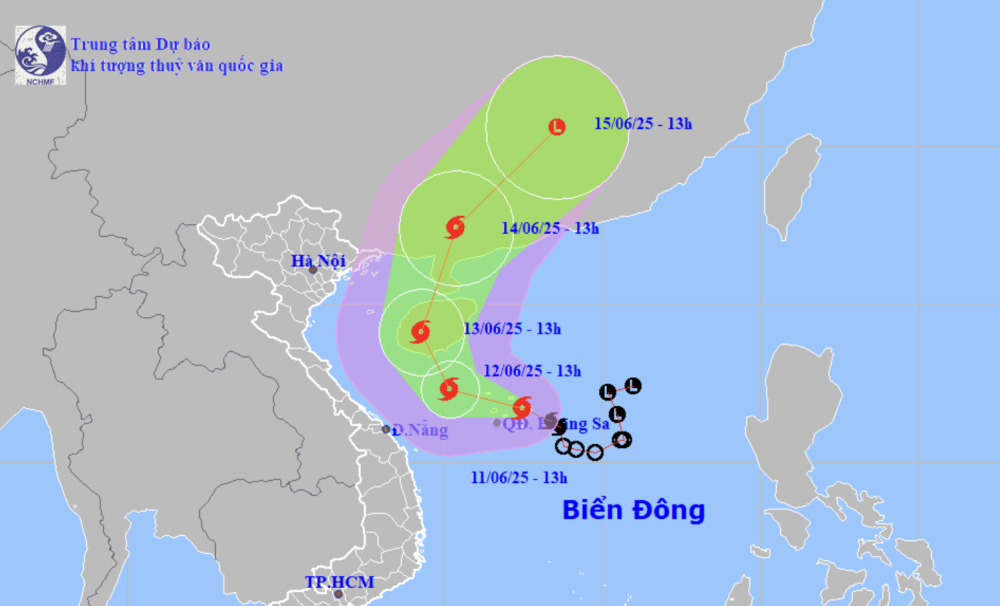
Forecast of location and direction of storm No. 1 at 1:00 p.m. today, June 11 (Photo: NCHMF)
On the afternoon of June 11, the Ministry of Agriculture and Environment held a meeting with ministries, branches and several central provinces to respond to storm No. 1 and heavy rain.
Speaking at the opening of the meeting, Deputy Minister of Agriculture and Environment Nguyen Hoang Hiep said that this year we welcomed the storm a bit earlier than previous years.
Due to the influence of the storm circulation, some localities in the Central region have had rain. Having rain at this time will be better for some localities in the Central region because it is the beginning of the dry season.
However, this storm has the risk of heavy rain in a short period of time in many locations, with the risk of flooding and landslides.
"With this storm, we are worried about ships at sea and local heavy rain because since the beginning of the season there has been a lot of local rain, and every rainstorm has caused damage," said Mr. Hiep, adding that the meeting was to review and prepare for response before, during and after the storm and heavy rain.
Mr. Mai Van Khiem - Director of the National Center for Hydro-Meteorological Forecasting - said that at 1:00 p.m. this afternoon, the storm center was east of Hoang Sa archipelago , the strongest wind near the storm center was level 8 (62-74 km/h), gusting to level 10.
"It is forecasted that this evening, the storm will move west-northwest at a speed of about 10km/h. From tonight and tomorrow, the storm is likely to move northwest and north towards Hainan Island (China).
In terms of intensity, the forecast is that strong winds of level 8 will remain today. Tomorrow the storm's intensity is likely to increase to level 9, and on June 13 it may increase to level 10," said Mr. Khiem.
According to Mr. Khiem, international forecasts from Japan, the US, and China all share the same opinion that the storm will move in an arc, towards Hainan Island, then enter mainland China.
In terms of intensity, most current forecasts predict the storm will reach a maximum intensity of level 10, with gusts of level 12. The storm is forecast to reach its maximum intensity around June 13, when it enters the sea south of Hainan Island.
"Data up to now shows no signs that this storm will increase in intensity to a very strong storm," said Mr. Khiem, adding that Vietnam's forecast has some options showing that the storm's intensity could reach level 11, but the probability is not high.
Mr. Mai Van Khiem commented on the storm's developments (Photo: C.TUỆ)
Regarding the impact of the storm, Mr. Khiem said that in the west of the northern East Sea (including the waters of the Hoang Sa archipelago), the north of the central East Sea area will have thunderstorms and strong winds of level 6-7, the area near the storm's center will have winds of level 8-9, gusting to level 11, waves 3-5m high, the strongest intensity can reach level 10, gusting to level 12.
Coastal sea areas from Quang Ninh - Quang Nam (Co To, Hon Ngu) have winds of level 5-6, gusts of 7, about 100km from shore (including Bach Long Vi, Con Co) have winds of level 6-7, gusts of 8-9.
The eastern part of the area near Hainan Island (China) has places with level 8, gusts of level 10-11, waves 3-5m high.
From the night of June 11, the offshore sea area from Quang Tri - Quang Ngai has winds gradually increasing to level 6-7, near the storm center level 8-9, gusting to level 11, waves 3-5m high.
Regarding heavy rain caused by storms, Mr. Khiem said that with the current scenario of storm movement, it could cause heavy rain in the Central provinces.
From tonight to the morning of June 13, the Central Central region (Quang Binh - Quang Ngai) will have rainfall from 100-300mm, with some places over 450mm.
Northern Central Highlands region has rainfall from 70-150mm, some places over 200mm. Warning of risk of localized heavy rain over 200mm in 6 hours.
From tonight to June 14, there is a possibility of a flood on rivers from Quang Binh to Quang Ngai. The flood peak is likely to reach and exceed alert level 1./.
According to a report from the Department of Dyke Management and Natural Disaster Prevention, to respond to the storm, the Border Guard Command has counted and instructed 53,792 boats/223,054 people on the developments and direction of the storm. Currently, ships in the affected area have received warning information and are moving to avoid it. For aquaculture, the total aquaculture area in coastal provinces from Quang Ninh - Khanh Hoa is 192,548 hectares, 272,367 cages; 3,848 aquaculture watchtowers are at risk of being affected by storms and floods. |
According to Tuoi Tre Newspaper
Source: https://tuoitre.vn/bao-witip-con-manh-them-co-the-dat-cap-10-giat-cap-12-20250611132802771.htm
Source: https://baolongan.vn/bao-wutip-con-manh-them-co-the-dat-cap-10-giat-cap-12-a196900.html
























Comment (0)