

Specifically, on the afternoon of August 23, international meteorological models predicted that the eye of storm Kajiki (storm number 5 according to Vietnam's name) could make landfall in Vietnam (North Central region) tomorrow morning, August 25. However, currently, these models have updated the forecast that the eye of the storm will make landfall from around noon to tomorrow afternoon, August 25.
On the morning of August 24, many international meteorological agencies shared the same warning that storm Kajiki was strengthening and heading towards the mainland of Central Vietnam around August 25, with strong winds of level 12-13, gusting to level 15 on the Vietnamese scale.
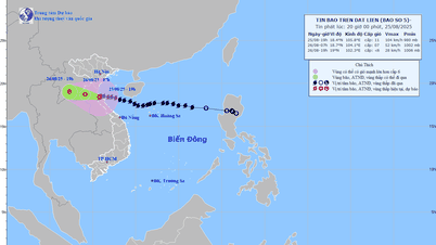
According to the Joint Typhoon Warning Center (JTWC) of the US Navy, at 6:00 a.m. on August 24 (Vietnam time), the storm's center was located in the northwest area of the Hoang Sa archipelago, with sustained winds of about 110-120 km/h (level 12), gusts of up to 140 km/h (level 14-15), and a central pressure of about 995 hPa.
JTWC forecasts that the storm will maintain its strong intensity as it moves west-northwest, making landfall in the Nghe An - Ha Tinh area on August 25, then gradually weakening as it moves deeper into mainland Laos.
Tropical Storm Risk (TSR) and Zoom Earth (UK) models, based on JTWC data, also reported that the storm is maintaining an intensity equivalent to level 12, with the potential to increase before approaching the coast of Vietnam, with the dangerous wind zone expanding, creating 6-9m high waves in coastal areas from Thanh Hoa to Quang Tri .

The Japan Meteorological Agency (JMA) and the Korea Meteorological Agency (KMA) both determined that the storm's center was in the southern part of the Gulf of Tonkin, moving west at a speed of 18-20km/hour.

The two agencies assessed that the storm is likely to reach peak intensity of level 13 in the next 12-18 hours, then make landfall in the Nghe An - Ha Tinh area, causing strong winds, widespread heavy rain and the risk of coastal flooding.
")
")
. Source: WINDY")
Data from AccuWeather and NOAA (National Oceanic and Atmospheric Administration) forecasting systems also show similar results, with the forecast that the center of storm Kajiki will make landfall in the North Central region of Vietnam on August 25, with winds reaching about 120-130km/h, gusting to 150km/h, then weakening into a tropical depression as it moves to Upper Laos.
 predicts that around the afternoon of August 25, the storm's eye will reach the shore.")
According to information updated from the National Center for Hydro-Meteorological Forecasting of Vietnam, as of 7:00 a.m. on August 24, the center of the storm had moved to an area with coordinates of about 17.5 degrees North latitude and 111.3 degrees East longitude, about 620km East Southeast of Nghe An, about 600km East of Ha Tinh. The storm is still at level 12, gusting to level 15, moving straight west but is showing a tendency to slow down to 15-20km/hour.
Mr. Hoang Duc Cuong, Deputy Director of the Department of Meteorology and Hydrology (Ministry of Agriculture and Environment) said that if the storm moves slower, it will accumulate more energy.
Source: https://www.sggp.org.vn/cac-co-quan-khi-tuong-quoc-te-du-bao-ve-bao-kajiki-post809885.html

![[Photo] General Secretary To Lam attends the 80th anniversary of Vietnam's diplomacy](https://vphoto.vietnam.vn/thumb/1200x675/vietnam/resource/IMAGE/2025/8/25/3dc715efdbf74937b6fe8072bac5cb30)


Comment (0)