
 |
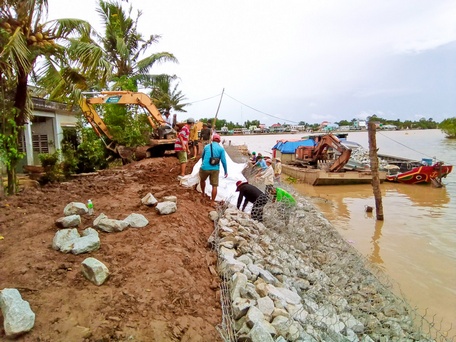
| Riverbank sections at risk of dangerous landslides need to be reinforced to prevent risks and damage during the rainy season. |
The weather in the province is in the rainy season. According to experts, during this period, along with storms, tornadoes, and heavy rains, landslides and riverbank collapses often occur. These are two worrying natural disasters and environmental problems for many years, not only in Vinh Long but also in many places in the Mekong Delta region every time the rainy and flood season comes.
Areas at risk of landslides
SL, land subsidence in the Mekong Delta in general and in our province in particular, although causing little loss of life, this type of natural disaster has destroyed a lot of land, constructions, and houses along the river.
According to experts from the Institute of Water Resources Science of the South, riverbank subsidence occurs when the soil mass on the riverbank is unbalanced, unstable and slides horizontally towards the riverbed. The riverbank becomes unbalanced or unstable due to waves, currents eroding the bank, eroding the riverbed or due to humans digging deep abysses near the bank, placing heavy objects close to the riverbank. As for land subsidence, the riverbank collapses vertically.
The riverbank is often eroded at the beginning of the rainy season because the riverbank soil in our province is often loose sandy clay soil, sandy loam soil, when soaked in rainwater it becomes soft and weak, low cohesion, pore pressure increases, easily becomes loose and the weight of the riverbank soil becomes heavier due to soaking in rainwater.
When the tide is low (low water), the seepage pressure of groundwater due to rainwater seeping into the ground pushes the bank soil out to the river, at that time the buoyant pressure of the river towards the bank is no longer due to low tide. The force holding the bank soil is smaller than the force pushing the bank soil out to the river, so the river bank is eroded. The erosion phenomenon is faster at low tide (low water).
According to statistics from the Irrigation Department, the province currently has 160 points with a SL speed of over 2 m/year with a total length of nearly 10km, mostly located on large rivers, canals and streams: in places where rivers and canals bend, the riverbanks have a flow direction that flows straight into the shore; in river mouths, wharf areas and canals and streams with many boats passing by; riverbanks where the Southwest monsoon and Northeast wind blow almost perpendicular to the riverbank, causing big waves to hit the shore without trees or structures to shield them from the outside...
Of which, there are 8 areas that have been severely affected by SL and have a high potential risk of SL, with the possibility of being severely affected by SL with a total length of 27,176m, including: the left bank of Co Chien River (from the beginning of Minh Islet in An Long Hamlet, An Binh Commune to Dinh Khao Ferry in Binh Hoa Phuoc Commune, Long Ho District) and Thanh Long Islet area in Quoi Thien Commune, Vung Liem District; on Hau River, there are the upper and lower areas of Hai Quy Canal, the area around Sung Islet (Binh Minh Town), the market area of Tich Thien Commune (Tra On District); Xang Canal (Luc Si Thanh Commune, Tra On District), Cai Cao River (Phu Duc Commune, Long Ho District), Mang Thit River (from Chanh An Ferry to Mang Thit Bridge in Vung Liem and Mang Thit Districts)... also at risk of being severely affected by SL.
Regarding the left bank of the Co Chien River, in April 2024, the Department of Agriculture and Rural Development coordinated with the Southern Institute of Water Resources to complete the assessment of the stability of this river bank, the section from Cai Ca canal to Ba Bong canal, 12km long, belonging to Hoa Ninh and An Binh communes (Long Ho district), Wards 1, 2, 5 (Vinh Long city).
Through topographic, hydrogeological and flow measurements, the Southern Institute of Water Resources Research warned that there are 3 riverbank sections on both sides of the Co Chien River that are at high risk of SL. Of which, on the left bank of Minh Islet, there are 2 sections of 750m long in Hoa Ninh Commune, the riverbed has a deep creek close to the shore with elevations from -28m to -35m; on the right bank of Ward 1 and Ward 5, nearly 1km long, there is a deep creek close to the shore with elevations from -35m to -38m.
Prevent landslides and river bank collapses
For many years, riverbank landslides have been a concern for riverside residents and a concern for local authorities in the province. However, the current difficulty is that regular forecasting of this type of natural disaster in Vinh Long or the Mekong Delta region has not been carried out as well as forecasting of other types of natural disasters, such as storms, tropical depressions, saltwater intrusion, high tides, and floods. Therefore, people are caught off guard and can only recognize them themselves or be notified a few days in advance based on a few familiar signs of landslides.
However, through topics, scientific research works, and projects applying topics and research works on SL and preventing SL on river banks in the Mekong Delta and Vinh Long, specialized agencies can provide trends in riverbed development, support erosion forecasting, and propose corrective solutions for many key erosion areas on major rivers in the region.
From there, it is recommended that local authorities need to notify and warn people to evacuate and limit production, construction, loading and unloading activities in areas at risk of SL.
To effectively prevent and avoid this type of natural disaster, it is necessary to urgently carry out propaganda and information work on the harmful effects of SL and riverbank subsidence; constructions and houses located close to riverbanks and canals must be inspected and stabilized.
People and property in buildings and houses showing signs of landslides must be immediately evacuated to a safe place. Households with the means should demolish existing solid houses next to the riverbank that are uninhabited to reduce the load on the riverbank and avoid the risk of landslides.
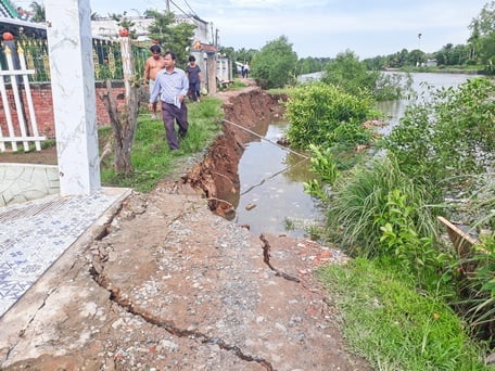 |
| Landslides and riverbank collapses have destroyed many houses and riverside structures. In the photo: The Cai Cao riverbank landslide in Phu Duc commune, Long Ho district on June 9, 2023. |
Warning of dangerous SL areas should be carried out to limit or stop activities around this area. Perennial trees growing near the riverbank should be cut down to avoid being blown down by strong winds and causing SL on the riverbank (this has happened in many places before at the beginning of the rainy season). The appearance of cracks in the riverbank parallel to the riverbank is a sign that the riverbank is about to be SL.
When a flood occurs, after emergency rescue operations (priority given to saving people) are carried out, all activities on the riverbank in the flood area must stop and stay away.
Do not reinforce the riverbank immediately after the landslide because the more shock and vibration causes, the more the bank soil will erode. Let the riverbank erode naturally until the riverbank is stable and no longer eroded before reinforcing the bank; do not leave heavy objects on the bank at the landslide site, these objects must be moved at least 50m from the bank. In addition, it is necessary to create a surface drainage ditch on the bank at the landslide site so that rainwater does not accumulate and increase the load on the bank soil, making the bank soil more eroded.
Article and photos: TRUNG CHANH
Source: https://baovinhlong.vn/thoi-su/202407/canh-bao-nguy-co-sat-lo-sup-lun-bo-song-3184741/


Comment (0)