

The book Dai Nam Nhat Thong Chi records:
- "The large gate of Cù Huân: located 19 miles east of Vĩnh Xương district; the estuary is 1,009 trượng wide, the depth at high tide is 8 thước 5 tấc, the depth at low tide is 7 tấc. To the north of the estuary is a rocky mountain, to the south is a sandbank, to the east are islands called Hòn Đỏ and Hòn Ô, guarded by a garrison commander and an assistant commander."

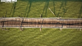
Cu Huan Gate - Xom Bong Bridge
Photo: Vuong Manh Cuong
- "The small estuary of Cù Huân: located 29 miles northeast of Vĩnh Xương district, the estuary is 190 trượng wide, the tide rises to a depth of 6 thước, the tide falls to a depth of 4 tấc. Outside the estuary are Lam Nguyên Island, Tâm Island, Ba La Island, Lớn Island, Môn Island, and surrounding islands where ships and boats gather. When the wind blows from the north, ships dock south of the mountains; when the wind blows from the south, ships dock north of the mountains. The estuary faces the sea. In autumn and winter, strong winds stir up sand, making it uninhabitable, so ships have to move to Lam Nguyên Island. In spring and summer, they return." ( Đại Nam nhất thống chí , Thuận Hóa Publishing House, 2006, volume 3, page 127).
The presentation in the Đại Nam nhất thống chí indicates that there are two seaports named Cù Huân: the Large Port and the Small Port, both branching off from a river also named Cù Huân that flows into the sea. Researcher Ngô Văn Ban specifically describes the two river branches as follows:
The Cái Cù Huân River flows from Diên Khánh district to Xuân Lạc village, Vĩnh Ngọc commune, where it splits into two branches:
- The first branch flows southeast, winding around the foot of Dong Bo mountain, then following the Quan Truong river down to Truong Tay and Truong Dong before emptying into the sea through the Tieu Cu Huan estuary, also known as Cua Be.
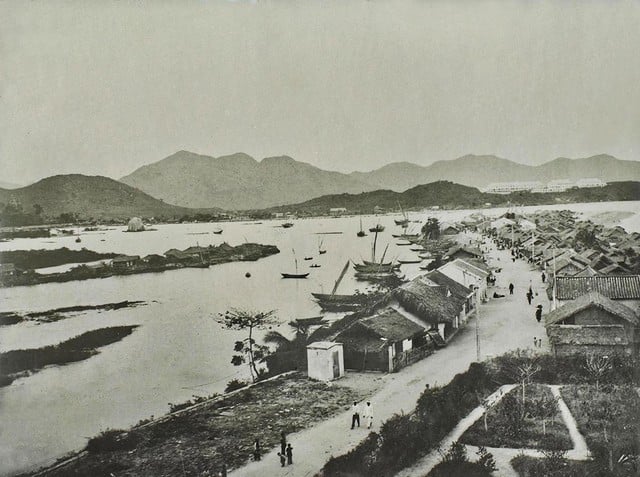
Cu Huan Gate - Con Hamlet, 1902
Photo: Archival material
- The second branch flows northeast, reaching Ngoc Hiep ward and splitting into two: One branch flows into Phuong Cui ward, passing through Truong Ca wharf in Phuong Sai ward, called Ngu Truong river, then flows down to Ha Ra. Here, the water swirls to form Xuong Huan lagoon (its written name is Cu Dam), which was later filled in to build Dam market. Half of the river water flows into the lagoon, and the other half flows down to Xom Con to reach the sea through Dai Cu Huan estuary, also known as the Big Gate or Nha Trang estuary. The second branch is wider and deeper, flowing down to Xom Bong in Vinh Tho ward and then to the sea, also through Dai Cu Huan estuary. The two branches of the river are like two outstretched arms, embracing an alluvial sandbank, popularly known as Con De (Goat Sandbank).
Con Hamlet is a cultural landmark associated with the Khanh Hoa - Nha Trang region. The people here mainly live by fishing. To the east is the sea, and to the west is the Cu Huan River. The formation of Con Hamlet at the mouth of the Cu Huan River began with the creation of a small hamlet called Bong Hamlet on the islet. It was called Bong Hamlet because the young women there were assigned by the elders to perform the Bong dance ritual and offer sacrifices during the Thien Ya Na festival at Thap Ba. In the past, merchant ships from other provinces transported goods to Nha Trang for trade. Some sailed up the Cai River to Dien Khanh district, while others turned into Xuong Huan lagoon to trade. Recognizing the lagoon's convenience for communication and living, people from various places settled there. Over time, many small hamlets were formed, such as Con Hamlet, Lach Hamlet, Ha Ra Hamlet, Gia Hamlet, and Cui Hamlet...
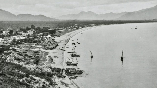
Chut Hamlet in the early 20th century
Photo: Archival material
Another coastal village bearing many cultural imprints of the Cu Huan estuary region is Chut hamlet (Truong Tay village). The book Dai Nam Quoc Am Tu Vi by Huynh Tinh Paulus Cua, published in Saigon in 1895, defines Chut as a small cove nestled against a cliff where boats can take shelter from the wind. This same book also clearly records the place name "Chut Nha Trang" as "A place sheltered from the wind in Nha Trang".
Chut hamlet - Truong Tay village, appears in the folk rhyme of the boatmen: "How far is it from Nha Trang to Chut?/Some go in to buy mattresses, others go out to buy blankets/Brothers are overjoyed and bustling/Some ask for directions, others ask for directions/Brothers drink tea and wine happily/When the Mieu beach is bustling, we'll glide in."
The above verse shows that boatmen traveling from South to North or from North to South would stop at Chut village to drink and chat, exchange information, and buy palm leaves to make sail mats and rattan to tie the masts.
The large Cu Huan estuary is now the area of Thap Ba and Xom Bong bridge. During the Nguyen dynasty, the Cu Huan estuary was located on the waterway from the capital Hue to Gia Dinh and also served as a boat stop. Phan Thanh Gian (1796 - 1867), the first person from Southern Vietnam to earn a doctorate, once stopped his boat at Cu Huan estuary and wrote an account of the legend of Lady Thien YA Na. Nguyen Quynh, the Governor of Khanh Hoa province, had an inscription carved on a stele erected behind the tower, which still stands today. In 1836, Truong Dang Que (1793 - 1865) was sent by Emperor Minh Mang to survey the six southern provinces. Stopping at Cu Huan on his way south, he composed the poem "Cu Huan Evening ," depicting the evening scene at Cu Huan estuary – both bustling and poetic, a place where the sky and sea captivated the heart.
In August 1885, when French troops landed on the Cai River, the patriot Trinh Phong directly commanded the resistance fighters to intercept the enemy at the river mouth. Trinh Phong cleverly lured the enemy deep into the river and then employed guerrilla tactics, inflicting heavy losses on them.
The people of the Cu Huan coastal region are gentle, honest, and deeply loyal and affectionate. This is also a land steeped in the cultural heritage passed down through generations. An old folk song expresses both love for their homeland and the profound loyalty of the people of this coastal village:
"When will Hon Chu be broken into four pieces?"
"The sea in Nha Trang was drying up, that's when I had to break off our relationship." (to be continued)
Source: https://thanhnien.vn/cua-cu-huan-mot-vung-troi-bien-huu-tinh-185250313195733498.htm
![[Image] Pleasant weather helps students enter the 10th grade entrance exam with confidence.](https://vphoto.vietnam.vn/thumb/1200x675/vietnam/resource/IMAGE/2026/05/29/1780034401612_ngay-1-thi-lop-10-minh-duy-8-5009-jpg.webp)



![[Photo] Ba Lang An Lighthouse - the "eye of the sea" amidst the "rock museum" of Quang Ngai province.](https://vphoto.vietnam.vn/thumb/1200x675/vietnam/resource/IMAGE/2026/05/29/1780038698840_anh-man-hinh-2026-05-29-luc-14-10-42.png)




































































Comment (0)