
WEATHER FORECAST ON LAND OF NGHE AN PROVINCE
(Day and night March 18, 2024)
* Coastal plain area:
Light rain in some places and scattered fog in the early morning, sunny in the afternoon and afternoon, showers and thunderstorms in some places in the evening and at night. East to southeast wind level 2 - level 3.
- Temperature: 22 – 29 degrees Celsius
- Humidity: 80 – 85%
* Midland and mountainous areas:
Morning and night cloudy with light rain in some places and scattered fog, noon and afternoon sunny, evening and night showers and thunderstorms in some places. East to southeast wind level 2.
- Temperature: 22 – 31 o C.
- Humidity: 80 – 90%
* Vinh City Area:
Morning and night cloudy with light rain and fog, noon and afternoon sunny, evening and night with occasional showers and thunderstorms. East to southeast wind level 2 - level 3.
- Temperature: 22 – 28 degrees Celsius
- Humidity: 80 – 85%
* Cua Lo and Ngu Island area:
Morning and night cloudy with light rain and fog, noon and afternoon sunny, evening and night with occasional showers and thunderstorms. East to southeast wind level 3 - level 4.
- Temperature: 22 – 27 degrees Celsius
- Humidity: 85 – 90%
* Next 48 hours : Under the influence of the continental cold high pressure increasing compression and filling the low pressure trough, Nghe An province will have cloudy weather, scattered rain, showers and thunderstorms in some places. Northeast wind level 2 - level 3. At night and early morning the weather will turn cold. During thunderstorms, beware of tornadoes, lightning, hail and strong winds.
NORTHEAST MONSOON NEWS
1. Weather developments in the past 24 hours:
Currently (March 18), the cold air mass is moving south.
2. Cold air forecast:
Forecast: From March 19, this cold air mass will affect the North Central region.
On land: Northeast wind inland level 2-3, coastal areas level 4 in some places. From the night of March 19, the weather in the North Central region will turn cold. During this cold air mass, the lowest temperature will be from 16 - 19 degrees.
At sea: from the night of March 18, in the Gulf of Tonkin, the wind will change to the Northeast and gradually increase to level 6, sometimes level 7, gusting to level 8, rough seas, waves from 1.5-2.5m high. From March 19, in the North East Sea, the wind will gradually increase to level 6, sometimes level 7, gusting to level 8-9, rough seas, waves from 2.0-4.0m high.
| Forecast time | Area of influence | Lowest temperature (degrees Celsius) | Average temperature (degrees Celsius) |
| Night of March 18 and March 19 | Thanh Hoa | 18 - 21 degrees Celsius | 21 - 23 degrees Celsius |
| Nghe An | 18 - 21 degrees Celsius | 21 - 23 degrees Celsius | |
| Ha Tinh | 18 - 21 degrees Celsius | 21 - 23 degrees Celsius |
3. Warning of possible natural disasters:
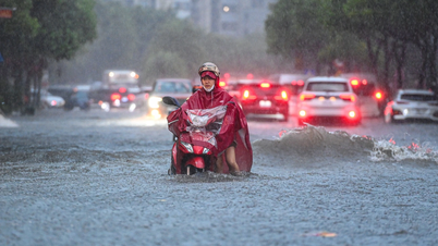
From the night of March 18-19, the Northern and North Central regions will have showers and scattered thunderstorms.
4. Potential impact on the environment, living conditions, infrastructure, and socio-economic activities
Thunderstorms accompanied by tornadoes, lightning, hail and strong gusts of wind can affect agricultural production, cause trees to fall, damage houses, traffic works and infrastructure. Thunderstorms can cause tornadoes, lightning, hail and strong gusts of wind, flash floods on small rivers and streams, and landslides on steep slopes.
Strong winds and large waves at sea are likely to affect boat operations and other activities.
Source

![[Photo] Prime Minister Pham Minh Chinh chaired a meeting of the Steering Committee on the arrangement of public service units under ministries, branches and localities.](https://vphoto.vietnam.vn/thumb/1200x675/vietnam/resource/IMAGE/2025/10/06/1759767137532_dsc-8743-jpg.webp)

![[Photo] Prime Minister Pham Minh Chinh chairs a meeting of the Government Standing Committee to remove obstacles for projects.](https://vphoto.vietnam.vn/thumb/1200x675/vietnam/resource/IMAGE/2025/10/06/1759768638313_dsc-9023-jpg.webp)


Comment (0)