
At 9:00 a.m. this morning, the National Center for Hydro-Meteorological Forecasting issued a level 4 disaster risk warning - an especially dangerous level for the eastern region of Dak Lak province. According to Deputy Director of the Center Hoang Van Dai, this is the warning level, issued when the area encounters a dangerous combination of: large floods, flash floods and landslides, which can cause great damage to life, property and infrastructure.
Currently, floods on the Ba, Kon and Krong Ana rivers are rising rapidly. Some stations have recorded particularly remarkable water levels.
Ba River at Cung Son rose to 35.92m, 1.42m higher than alarm level 3; at Phu Lam it reached 3.94m, 0.24m higher than alarm level 3.
Kon River at Thach Hoa has reached alarm level 3 (8m).
Krong Ana River in Giang Son exceeded alarm level 2 by 0.02m.
It is forecasted that in the next 12 hours, the flood on Ba River at Phu Lam station will continue to rise and stay above warning level 3 (at the historical flood level in 1993: 5.21m) and Kon River will continue to rise and remain above warning level 3.
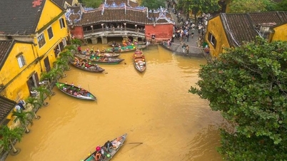
Floods continue to develop complicatedly when it is forecasted that in the next 24 hours, the flood situation on main rivers is likely to remain at a very high level, while widespread flooding occurs in provinces from Thua Thien Hue to Khanh Hoa .

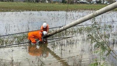
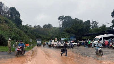
Soldiers respond to support isolated people in Yang Mao commune, Dak Lak. Photo: Dak Lak Electronic Newspaper.
As of this morning, many rivers from Hue City, Da Nang, Quang Nam , Quang Ngai, Gia Lai to Khanh Hoa are also fluctuating at alert levels 1-3, including Dinh River (Khanh Hoa) which is above alert level 3. Specifically, the water level at 7am at the stations is as follows:
In Hue City, the Huong River at Kim Long station is 1.53m, 0.47m below alert level 2; at Phu Oc it is 2.81m, 0.19m below alert level 2.
In Da Nang city, Vu Gia river at Ai Nghia station is 7.8m, 0.2m above alert level 2; Thu Bon river at Cau Lau station is 3.22m, 0.22m above alert level 2.
In Quang Ngai, Tra Khuc River is only 0.04m below alarm level 2 and continues to rise.
In Khanh Hoa, Dinh Ninh Hoa river at Ninh Hoa station is 5.77m, on BĐ3 is 0.07m; Cai Nha Trang river at Dong Trang station is 8.52m, on BĐ1 is 0.52m.
. Radar images show that the heaviest rain areas (yellow) are concentrated in Gia Lai, Dak Lak, Khanh Hoa and part of the eastern part of Lam Dong province. Photo: NCHMF.")
Flood map in the Central region at 9am on November 19 (each flag represents an alert level). Radar images show that the heaviest rain areas (yellow) are concentrated in Gia Lai, Dak Lak, Khanh Hoa and part of the eastern part of Lam Dong province. Photo: NCHMF .
Currently, the risk of flash floods on small rivers and streams and landslides on steep slopes in the Central and Central Highlands regions is very high. Many residential areas, especially low-lying areas, downstream areas of reservoirs and riverside areas, are likely to be deeply flooded in the coming hours.
The National Center for Hydro-Meteorological Forecasting recommends that people limit their movement through deep flooded areas, overflow areas, and landslide-prone slopes; proactively evacuate dangerous areas as requested by local authorities. Subsequent bulletins will be updated continuously, especially when there are changes in the operation and regulation of upstream reservoirs.
Source: https://nongnghiepmoitruong.vn/khan-cap-lu-o-dak-lak-len-nhanh-cuc-ky-nguy-hiem-d785186.html


![[Photo] National Assembly Chairman Tran Thanh Man holds talks with South Korean National Assembly Chairman Woo Won Shik](/_next/image?url=https%3A%2F%2Fvphoto.vietnam.vn%2Fthumb%2F1200x675%2Fvietnam%2Fresource%2FIMAGE%2F2025%2F11%2F20%2F1763629724919_hq-5175-jpg.webp&w=3840&q=75)
![[Photo] President Luong Cuong receives President of the Senate of the Czech Republic Milos Vystrcil](/_next/image?url=https%3A%2F%2Fvphoto.vietnam.vn%2Fthumb%2F1200x675%2Fvietnam%2Fresource%2FIMAGE%2F2025%2F11%2F20%2F1763629737266_ndo_br_1-jpg.webp&w=3840&q=75)
![[Photo] Lam Dong: Panoramic view of Lien Khuong waterfall rolling like never before](/_next/image?url=https%3A%2F%2Fvphoto.vietnam.vn%2Fthumb%2F1200x675%2Fvietnam%2Fresource%2FIMAGE%2F2025%2F11%2F20%2F1763633331783_lk7-jpg.webp&w=3840&q=75)


Comment (0)