
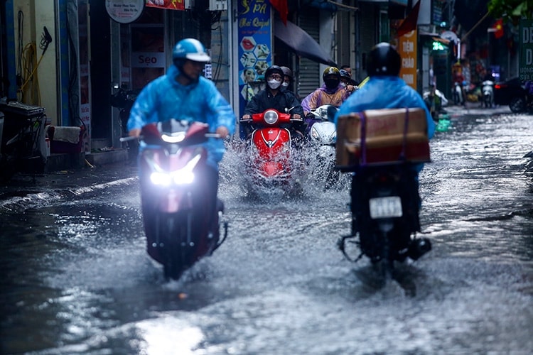
Heavy rains in a short period of time increase the risk of flash floods in small rivers and streams, landslides on steep slopes, especially in the northern mountainous areas and Thanh Hoa. In addition, localized flooding may occur in low-lying areas and densely populated urban areas.
According to rainfall records from the night of June 30 to the early morning of July 1, many places in the North had very heavy rain. In Thu Lum ( Lai Chau ), rainfall was recorded at 154.2 mm; Tien Nguyen 2 (Tuyen Quang) at 112.8 mm; Ban Qua (Lao Cai) at 109.4 mm; and Phuc Do (Thanh Hoa) at 103 mm. These heavy rains have caused many difficulties for people, especially in areas at high risk of landslides.
Not only affecting the Northern region, during the day and night of July 1, the strip of land from Nghe An to Lam Dong and the Southern region will also have scattered showers and thunderstorms. Some places may have heavy rain, with common rainfall of 10 - 30 mm, locally over 70 mm, concentrated in the evening and at night. During thunderstorms, there is a high possibility of tornadoes, lightning, hail and strong gusts of wind, posing potential risks to agricultural production, transport infrastructure and people's lives.
It is forecasted that from July 3, heavy rain in the Northern region will gradually decrease, however, people still need to closely monitor weather developments and proactively take measures to prevent and avoid natural disasters that may occur unexpectedly.
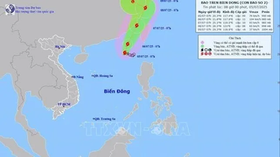
At sea, in the next 24 hours, the Gulf of Tonkin, the North East Sea (including the Hoang Sa sea area), the central and southern East Sea (including the Truong Sa sea area), as well as the Gulf of Thailand will continue to have heavy showers and thunderstorms. Particularly, the sea area from Lam Dong to Ca Mau will have strong winds southwest of level 5, sometimes level 6, gusting to level 7, waves from 1.5 to 2.5m high, causing rough seas.
Warning: During thunderstorms, there is a possibility of tornadoes, strong winds of level 6-7 and waves over 2 meters high. Ships operating in dangerous sea areas need to pay close attention and regularly monitor forecast information to proactively avoid and ensure the safety of people and property.
Faced with complicated weather developments, local authorities need to direct functional forces to review areas at high risk of landslides and flooding to have plans to evacuate residents and limit damage to people and property.
Weather forecast for regions across the country:
Hanoi capital is cloudy, with rain, moderate rain and scattered thunderstorms, locally heavy rain. Southeast wind level 2 - 3. During thunderstorms, there is a possibility of tornadoes, lightning and strong gusts of wind. Lowest temperature 24 - 26 degrees Celsius. Highest temperature 28 - 30 degrees Celsius.
The Northwestern region is cloudy with moderate rain, heavy rain and thunderstorms, locally very heavy rain. Light wind. During thunderstorms, there is a possibility of tornadoes, lightning, hail and strong gusts of wind. The lowest temperature is 22 - 25 degrees Celsius, some places below 22 degrees Celsius. The highest temperature is 27 - 30 degrees Celsius.
The northeastern provinces are cloudy with moderate rain, heavy rain and thunderstorms, some places have very heavy rain. Southeast wind level 2 - 3. During thunderstorms, there is a possibility of tornadoes, lightning, hail and strong gusts of wind. The lowest temperature is 23 - 26 degrees Celsius, in mountainous areas some places are below 23 degrees Celsius. The highest temperature is 27 - 30 degrees Celsius, some places are above 30 degrees Celsius.
Provinces from Thanh Hoa to Hue are cloudy with scattered showers and thunderstorms, locally heavy rain. Light wind. During thunderstorms, there is a possibility of tornadoes, lightning and strong gusts of wind. Lowest temperature 24 - 27 degrees Celsius. Highest temperature 31 - 34 degrees Celsius.
The South Central Coast region is cloudy with scattered showers and thunderstorms; In the afternoon and evening, there will be scattered showers and thunderstorms, with some heavy rain in some places. Southwestern winds level 2 - 3. There is a possibility of tornadoes, lightning and strong gusts of wind during thunderstorms. Lowest temperature 25 - 28 degrees Celsius. Highest temperature 32 - 35 degrees Celsius.
The Central Highlands is cloudy with scattered showers and thunderstorms; In the late afternoon and evening there will be scattered showers and thunderstorms, with some heavy rain in some places. West to southwest winds at level 2-3. There is a possibility of tornadoes, lightning and strong gusts of wind during thunderstorms. The lowest temperature is 20-23 degrees Celsius. The highest temperature is 27-30 degrees Celsius, with some places above 31 degrees Celsius.
The South is cloudy with scattered showers and thunderstorms; In the late afternoon and evening there will be scattered showers and thunderstorms, with some heavy rain in some places. Southwestern winds level 2-3. There is a possibility of tornadoes, lightning and strong gusts of wind during thunderstorms. Lowest temperature 24-27 degrees Celsius. Highest temperature 31-34 degrees Celsius, with some places above 34 degrees Celsius.
Source: https://baohaiphongplus.vn/mua-lon-don-dap-o-bac-bo-415354.html


![[OCOP REVIEW] Bay Quyen sticky rice cake: A hometown specialty that has reached new heights thanks to its brand reputation](https://vphoto.vietnam.vn/thumb/402x226/vietnam/resource/IMAGE/2025/7/3/1a7e35c028bf46199ee1ec6b3ba0069e)


Comment (0)