
Researchers have discovered the geological process that led to the creation of the continent of Zealandia, which is now largely submerged under the ocean.
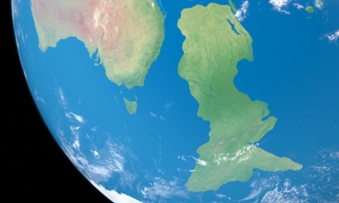
Simulation of the continent of Zealandia. Photo: Ianm35/Creatas Video +
When the ancient supercontinent Gondwana broke apart 83 million years ago, a huge chunk of it sank beneath the waves as it drifted. According to some geologists, the submerged piece, called Zealandia, would have been Earth’s eighth continent if it hadn’t been obscured by a thick layer of ocean water. Instead, all that protrudes above the ocean surface of the continent is New Zealand and its surrounding islands, so Zealandia has long remained a great mystery.
About 94% of the 4.9 million square kilometer continent is submerged, obscuring details of the northern part of the strip. Using geochemical and isotopic data from newly dredged rock samples as well as seismic data, researcher Andy Tulloch of the Institute of Geology and Nuclear Sciences (GNS) and colleagues created a map of the area to understand how the continent formed. They published their research results in the journal Tectonics, Science Alert reported on September 21.
Rock samples, some dating back to the age of the dinosaurs, were taken from several exploration drilling sites and some of Zealandia's southern outcrops, such as the Chatham Islands and the Antipodes. Analysis of the samples' chemical composition, along with other geological evidence that has similarities to West Antarctica, suggests that the edge of Zealandia was subducted 250 million years ago, in what is now the Campbell Plateau on New Zealand's west coast.
Subduction occurs when two plates of Earth’s crust push against each other, causing one to sink into the mantle. But contrary to previous speculation, magnetic anomalies in the same region are not linked to this event, Tulloch’s team found. Both Zealandia and Antarctica are significantly deformed internally. The team suggests the Campbell Magnetic Anomaly System was created by the stretching of different parts of Gondwana. Eventually, they broke apart to form the seafloor surrounding Zealandia.
First, Zealandia/West Antarctica and Antarctica/Australia broke apart, allowing the Tasman Sea to flood in about 83 million years ago. Then, at the end of the Cretaceous period about 78 million years ago, Zealandia and West Antarctica split apart, forming the Pacific Ocean .
The process by which Zealandia’s crust was stretched so thin before breaking apart has puzzled geologists. West Antarctica has shown similar thinning. Tulloch and his colleagues found evidence of a 65-degree shift in the direction of the stretching between 100 and 80 million years ago. They believe this caused the continental crust to thin. The new findings should lay the groundwork for scientists to analyze the Earth’s strange stretching in more detail.
An Khang (According to Science Alert )
Source link


![[Photo] Hanoi morning of October 1: Prolonged flooding, people wade to work](https://vphoto.vietnam.vn/thumb/1200x675/vietnam/resource/IMAGE/2025/10/1/189be28938e3493fa26b2938efa2059e)


![[Photo] Panorama of the cable-stayed bridge, the final bottleneck of the Ben Luc-Long Thanh expressway](https://vphoto.vietnam.vn/thumb/1200x675/vietnam/resource/IMAGE/2025/9/30/391fdf21025541d6b2f092e49a17243f)
![[Photo] President Luong Cuong receives President of the Cuban National Assembly Esteban Lazo Hernandez](https://vphoto.vietnam.vn/thumb/1200x675/vietnam/resource/IMAGE/2025/9/30/4d38932911c24f6ea1936252bd5427fa)


![[Infographics] An Giang economic picture in the period 2020 - 2025](https://vphoto.vietnam.vn/thumb/402x226/vietnam/resource/IMAGE/2025/10/1/093e29084648496c82a22536f5384c21)


Comment (0)