
(QBĐT) - The Nine Bronze Tripods at the Hue Imperial Citadel are priceless bronze treasures of Vietnam. The Nine Tripods represent Vietnam through images of rivers, mountains, passes, seaports, and local products. Like other localities, the landscapes of Quang Binh are also depicted on each of the Nine Tripods – a source of pride for the people of Quang Binh throughout history.
Images of Quang Binh's past landscapes evoke memories of the present: the legendary Gianh River, the magnificent Quang Binh citadel gate standing proudly to the north of the capital, the majestic Hoanh Son mountain range, and a sacred border pass. All of these still exist with the sky, the earth, and the people today.
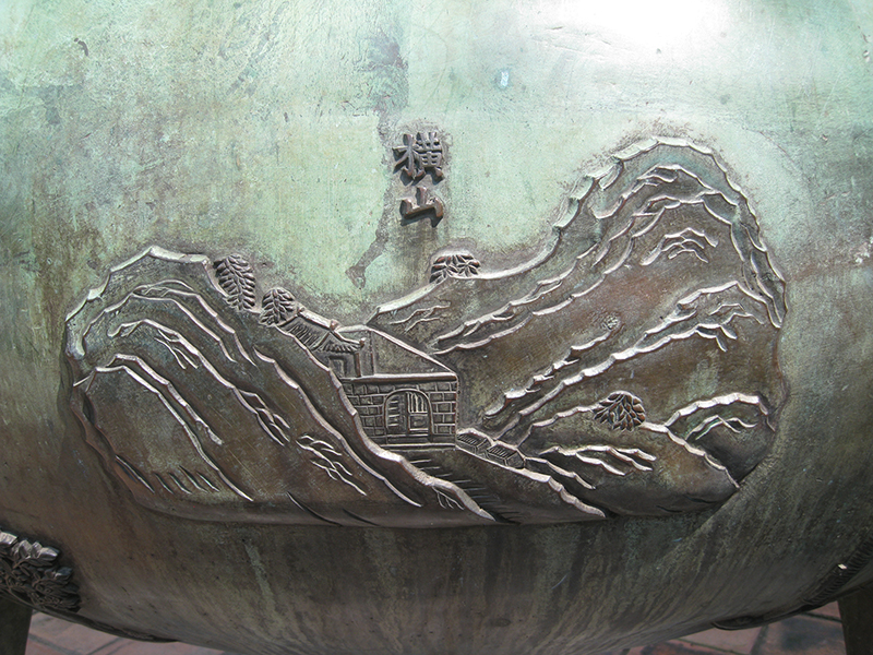
In the Nine Tripods, when mentioning images of mountains, there are nine large mountains that are carved and preserved, including: Ngu Binh Mountain, Thuong Son and Due Son in Thua Thien-Hue, Dai Lan Mountain bordering Phu Yen and Khanh Hoa provinces, Hai Van Pass between Thua Thien-Hue and Da Nang, Hong Son Mountain in Ha Tinh, Hoanh Son Mountain in Quang Binh, Thien Ton Mountain in Thanh Hoa, and Tan Vien Mountain in Hanoi .
Nine major rivers are depicted on the Nine Tripods, including: Ngu Chu Giang (Ben Nghe River), Huong Giang (Huong River) in Thua Thien-Hue, Linh Giang (Gianh River) in Quang Binh, Ma Giang (Ma River) in Thanh Hoa, Thach Han Giang (Thach Han River) in Quang Tri, Lam Giang (Lam River) in Nghe An, Nhi Ha (Red River) in the northern provinces and Hanoi, Lo Ha (Lo River) flowing through Ha Giang, Tuyen Quang, Phu Tho, and Vinh Phuc provinces, and Bach Dang Giang (Bach Dang River) in Quang Ninh and Hai Phong .
 |
Nine sea gates, gateways, seas, and rainbows are depicted on the Nine Dynastic Urns, including: the East Sea (Eastern Vietnam), the South Sea (Southern Vietnam), the West Sea (Western Vietnam), Thuan An estuary (Thuan An port) in Thua Thien-Hue, Can Gio estuary (Can Gio port) in Ho Chi Minh City, Da Nang estuary (Da Nang port), Quang Binh gate (Quang Binh city gate), Hong (rainbow), and the estuaries of the Tien and Hau rivers in Southern Vietnam.
Thus, in terms of geographical names, Quang Binh has Hoanh Son mountain, Quang Binh citadel gate, and Gianh river, all depicted on the Nine Dynastic Urns. These places are included because of their distinct cultural and historical significance, and because all three locations are associated with the Nguyen lords and the early Nguyen dynasty kings.
In the book "Vietnam Through the Nine Dynastic Urns of Hue" by Duong Phuoc Thu: The Linh River, also known as the Gianh River, has clear, blue water year-round, hence its other name, the Thanh Ha River. The riverbed is approximately 680 meters wide on average, with the widest section exceeding 1,000 meters. From its source to the sea, it stretches about 160 kilometers, originating from three sources: from Thanh Lanh Mountain to the border of Huong Khe District (Ha Tinh Province), flowing through Tuyen Hoa District to the La Ha River; from Kim Linh Mountain, flowing through Cao Mai Mountain, the river is slightly deeper and wider, merging with the La Ha River in Yen Le Commune; and from Son An Nau, flowing east through Minh Hoa District, joining the La Ha River, and then emptying into the sea at the Gianh River estuary. Along both banks of the river, from the source downwards, are entirely limestone mountains.
Researcher Duong Phuoc Thu has suggested that: Following the prophecy of Trang Trinh, Nguyen Hoang, in 1558, received orders from the newly appointed Le king to govern and develop Dang Trong (Southern Vietnam), using the Hoanh Son mountain range and the Gianh River as strategic locations. After his death in 1613, his son, Lord Sai Nguyen Phuc Nguyen, taking advantage of Lord Trinh Trang's orders to send troops to attack, confronted Dang Ngoai (Northern Vietnam), using this river as a boundary. Therefore, the names "Nam Ha - Dang Trong" and "Bac Ha - Dang Ngoai" were established, reflecting the conflict between the Trinh and Nguyen families, who divided the country and separated the land from that time onwards for over 200 years.
Approaching the estuary, commonly known as Gianh estuary, the waves are fierce, the two banks separated like a moat created by nature, and together with Nhat Le, they form a strategically important position both inside and outside the area.
In the past, when people from the North ventured south and crossed the Gianh River, they had a song that went like this:
"Even the strong and clever can overcome Thanh Ha."
Even with wings, it's difficult to cross the long rampart."
It means that the mountains and rivers here are rugged and difficult to cross ([1]).
Thus, the Gianh River holds great importance in the geopolitical perspective of the Dang Trong region to this day. Therefore, in the 17th year of Minh Mang's reign, after the Nine Dynastic Urns were cast, the image of the Gianh River was engraved on the Chuong Urn. In the 4th year of Thieu Tri's reign, a stone stele was erected on the southern bank, and at the beginning of Tu Duc's reign, it was recorded in the official records, with officials annually sending offerings to worship it.
Quang Binh Gate is the 16th image carved on the Nghi Dinh, which is the Quang Binh city gate, also known as Dong Hoi city gate, located to the east on the Dinh Bac Truong Thanh system. During the reign of Lord Nguyen Phuc Nguyen, military strategist Dao Duy Tu (1572-1634) suggested building ramparts at Nhat Le. This gate was made of earth along with two other gates, Ly Chinh Dai Quan (later renamed Vo Thang Quan) and Thu Ngu, to defend the Nhat Le sea side.
According to researcher Duong Phuoc Thu: “The Dinh Bac Truong Thanh system is 3,000 truong long, from Dau Mau to Nhat Le gate, creating a solid military defense line to prevent enemy attacks. Thanks to this military fortress, the Nguyen lords were more confident when advancing south. Later, to commemorate the merits of military strategist Dao Duy Tu, people called this project Teacher's Fortress. In the past, the road from the North to Phu Xuan had to go through Quang Binh city gate. But then over time it became dilapidated, and it was only during the Nguyen king's time that it was repaired” ([2]).
Quang Binh Gate is the pride of the dynasty, associated with the founding national hero Dao Duy Tu. In addition, it has high historical and cultural value, and is a symbol of the land of Quang Binh, a land of outstanding people and spiritual significance. In 1996, Quang Binh restored the only symbol of the city gate that was chosen to be engraved on the Nine Tripods ([3]).
Hoành Sơn, the seventh peak on Huyền Đỉnh, is a horizontal mountain range that marks the natural boundary between Hà Tĩnh and Quảng Bình provinces. The winding, undulating mountain range is the reason it's commonly known as Ngang Pass (Horizontal Pass). The pass is 256 meters high and 6 kilometers long, bordering Kỳ Anh district in Hà Tĩnh province.
During the conflict between the Northern and Southern regions of Vietnam, the Gianh River served as the boundary, meaning the mountain belonged to the Northern region. At the beginning of the Gia Long era, the Quang Binh garrison was established, using this mountain as the boundary between Nghe An and Quang Binh (at that time, Ha Tinh province had not yet been established). In the 14th year of the Minh Mang reign, the court established a pass and stationed troops for defense. In the 17th year of the Minh Mang reign, the Nine Dynastic Urns were cast, and the image of Hoanh Son was engraved on the Huyen Urn.
Hoành Sơn has also been immortalized in the poetry of many generations, especially in the poem "Crossing the Ngang Pass" by Bà Huyện Thanh Quan:
Approaching the Ngang Pass, the setting sun cast its shadows.
Grass and plants mingle with rocks, leaves mingle with flowers.
Crouching low beneath the mountain, a few woodcutters
Scattered along the riverbank, there are a few market stalls.
Missing my homeland, my heart aches, the cuckoo cries.
I'm so worried about my family, I'm tired of talking so much, Grandpa.
Stop and gaze at the sky, mountains, and water.
A private love affair, just between me and myself.
Now, the Ngang Pass has changed significantly from the past, with a road tunnel connecting the route, and the lives of the local people have changed considerably. The old pass road is now an attractive tourist destination for visitors passing through Quang Binh. Standing on the Ngang Pass, one can admire the vast ocean in the distance, with Vung Chua-Yen Island, Hon La, Hon Gio, and Hon Nom.
Besides the three famous landmarks depicted on the Chương, Nghị, and Huyền tripods of the Nine Tripods, the Quang Binh region also boasts a variety of products from its mountains, forests, rivers, and seas, contributing to the rich diversity of products in the Dang Trong region, Dai Nam, and Vietnam, both past and present.
When observing the Nine Tripods, there are many products whose images are carved on the Nine Tripods that are in the Quang Binh region, such as: Pheasant, whose image is carved on the Cao Tripod placed in the center, symbolizing greatness. Agarwood and jackfruit are carved on the Cao Tripod. On the Chuong Tripod, Quang Binh products also have the common name of shallots. Mulberry tree, whose image is carved on the Anh Tripod, Researcher Duong Phuoc Thu said, "In Quang Binh province there is a mountain mulberry tree different from the silkworm mulberry tree" ([4]).
The swallow (Yen Oa) sculpture is cast on the Chuong Dinh peak. The five-leaf orchid, also known as the five-leaved orchid, is cast on the Huyen Dinh peak.
The landscape of Quang Binh, depicted in the image of the Nine Dynastic Urns, portrays a land that suffered greatly during the war but is also remarkably heroic. Quang Binh is also rich in mineral resources. For example, the Gianh River is teeming with shrimp, crabs, and fish. The Ngang Pass and the Quang Binh citadel are now ideal tourist destinations. Furthermore, Quang Binh possesses numerous historical sites, scenic spots, and beautiful caves, attracting an increasing number of visitors.
Tran Nguyen Khanh Phong
[1], [2], [3], [4]: Duong Phuoc Thu: The country of Vietnam through the Nine Bronze Tripods of Hue (Research on the Nine Bronze Tripods, priceless treasures of Vietnam). Tri Thuc Publishing House, Hanoi, 2011, page 123, page 183, page 155.
Source: https://www.baoquangbinh.vn/van-hoa/202409/non-nuoc-quang-binh-tren-hinh-cuu-dinh-2221160/


![[Photo] General Secretary and President To Lam presides over a meeting on preparations for the review of one year of operation of the three-tiered government system.](https://vphoto.vietnam.vn/thumb/1200x675/vietnam/resource/IMAGE/2026/06/02/1780391821195_a1-bnd-4595-9717-jpg.webp)


Comment (0)