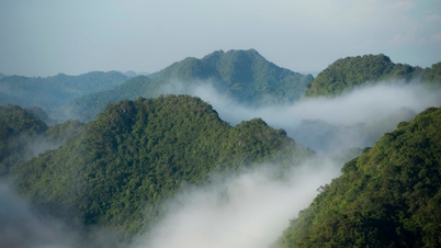
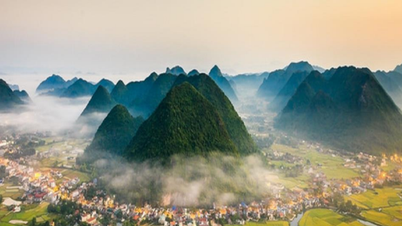
Panoramic view of the 3 highest peaks of Ba Vi mountain range
Báo Dân trí•25/03/2024
(Dan Tri) - Ba Vi mountain is sturdy and towering like a fulcrum of Hanoi . With sharp peaks like spears, Ba Vi mountain is both majestic and has green vegetation all year round.
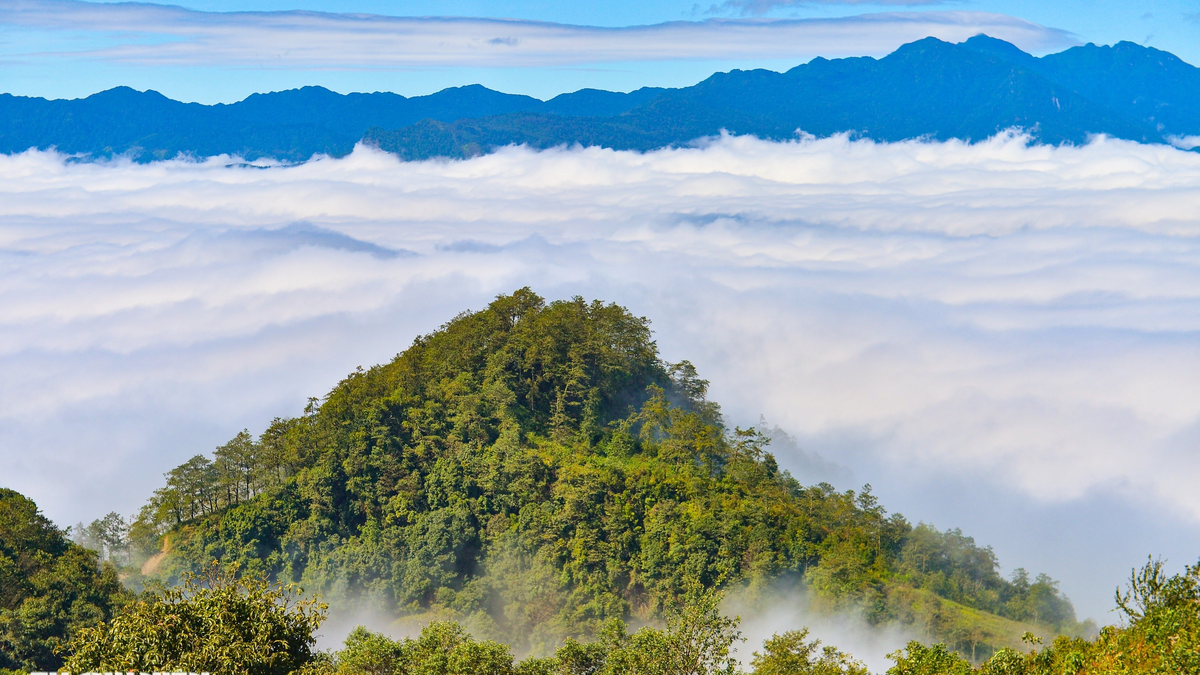
According to scientific research, the Ba Vi mountain range was created by erosion and fragmentation of the Red River bedrock. The geology in Ba Vi is very stable, formed from tectonic movements that occurred about 200 million years ago, belonging to the Indochina and South China arcs. Ba Vi National Park has a total area of 9,702.41 hectares, belonging to the administrative boundaries of 15 communes in 3 districts of Hanoi and 2 districts and cities of Hoa Binh province. In the photo is the view from the highest peak down to the Da River. At the King Peak (the highest peak), Bao Thien Bao Thap was built in 2010 with 13 floors, 26.9m high, designed in 4 directions, 8 directions, main door facing South. The Ho Chi Minh Temple is located on the top of Vua Mountain, facing the South. Inside is a statue of Uncle Ho cast in pure red copper in a 1:1 ratio, modeled after a photo taken by photographer Dinh Dang Dinh, in the pose of Uncle Ho sitting with one hand holding the Nhan Dan newspaper and the other holding a pair of glasses. King Peak is 1,296m above sea level, where Uncle Ho's temple and 13-storey tower are located. Tan Vien Peak is 1,227m high (the second highest peak), located under a narrow mountain roof, Tan Vien Mountain. The Upper Temple located on the top of Tan Vien is also called the Main Palace of the Gods, is the place to worship Saint Tan Vien Son. Photo of the two highest peaks of Ba Vi Mountain: On the left is Vua Peak at 1,296m high; on the right is Tan Vien Peak at 1,227m high. Panoramic photo of Uncle Ho's temple located on King peak of Ba Vi mountain. Ngoc Hoa Peak is 1,131m high, the third highest in Ba Vi mountain range. Ba Vi's climate is characterized by fog covering almost all year round. From an altitude of 300m, Ba Vi mountain is often covered by a thin layer of fog like smoke. From an altitude of 400m, the climate is like a miniature Da Lat, where the pine hills are sexy with a dreamy romantic look. From an altitude of 600m, even when it is sunny, fog still lingers in the trees and leaves. Ba Vi Mountain is cool and fresh, the temperature decreases with altitude. At an altitude of 500-700m, the average annual temperature is about 19-20 degrees Celsius. At an altitude of 900-1,000m, the average annual temperature drops to 18 degrees Celsius. From Ba Vi mountain looking down at Da river is rarely seen clearly because it is often covered by clouds. Ba Vi National Park has 3 forest types: Tropical humid evergreen closed forest; Tropical mixed evergreen broadleaf and coniferous closed forest; Tropical humid evergreen broadleaf forest on low mountains. Ba Vi Mountain has two high altitudes, so the flora here is rich and diverse. 2,181 species of higher plants belonging to 207 families and 958 genera have been recorded here. Many rare species of trees such as Calocedrus marcrolepis, Podocarpus nerrifolius, sen mat, giổi lá Bạc, Quyết thân Gỗ, Bát Giác Liên... In the National Park, 896 species of medicinal plants have also been recorded. The sunshine in Ba Vi lasts all day on the western slopes, not harsh in summer. Winter is typical of humid subtropical monsoon weather. The photo of Vua peak and Bao Thien tower is clear when a cloud passes by.


 Báo Dân trí•25/03/2024


![[Photo] Unique architecture of the deepest metro station in France](https://vphoto.vietnam.vn/thumb/1200x675/vietnam/resource/IMAGE/2025/11/14/1763107592365_ga-sau-nhat-nuoc-phap-duy-1-6403-jpg.webp)


Comment (0)