
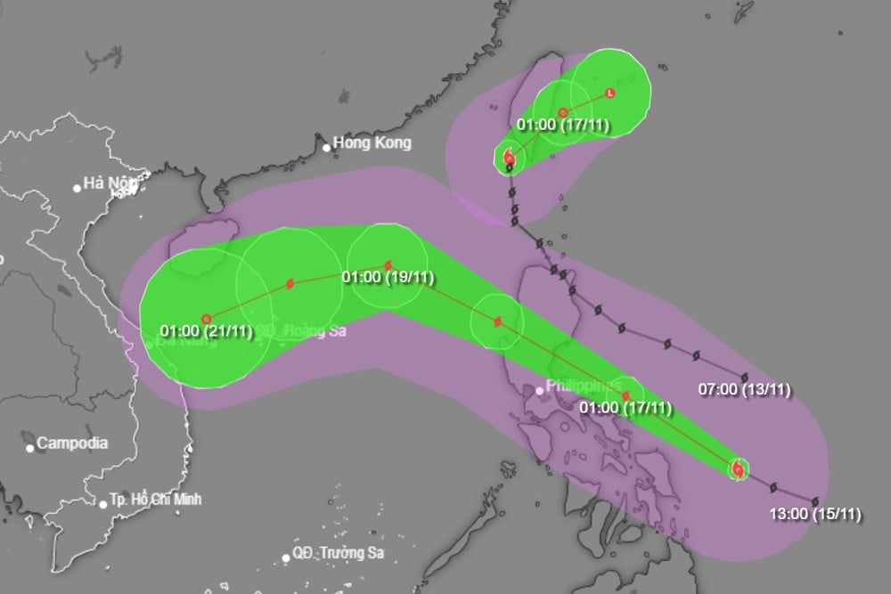
Super Typhoon Man-yi continues at level 16 intensity, with gusts exceeding level 17. It is predicted that after crossing Luzon Island (Philippines), around November 18th, the typhoon will move into the South China Sea, becoming typhoon number 9, but will rapidly weaken upon encountering cold air.
According to the National Center for Hydro-Meteorological Forecasting, as of 7 PM tonight (November 16th), the center of Super Typhoon Man-yi is located in the sea east of the central Philippines. The strongest winds near the center of the super typhoon are at level 16 (184-201 km/h), with gusts exceeding level 17. It is moving northwest at a speed of 20 km/h.
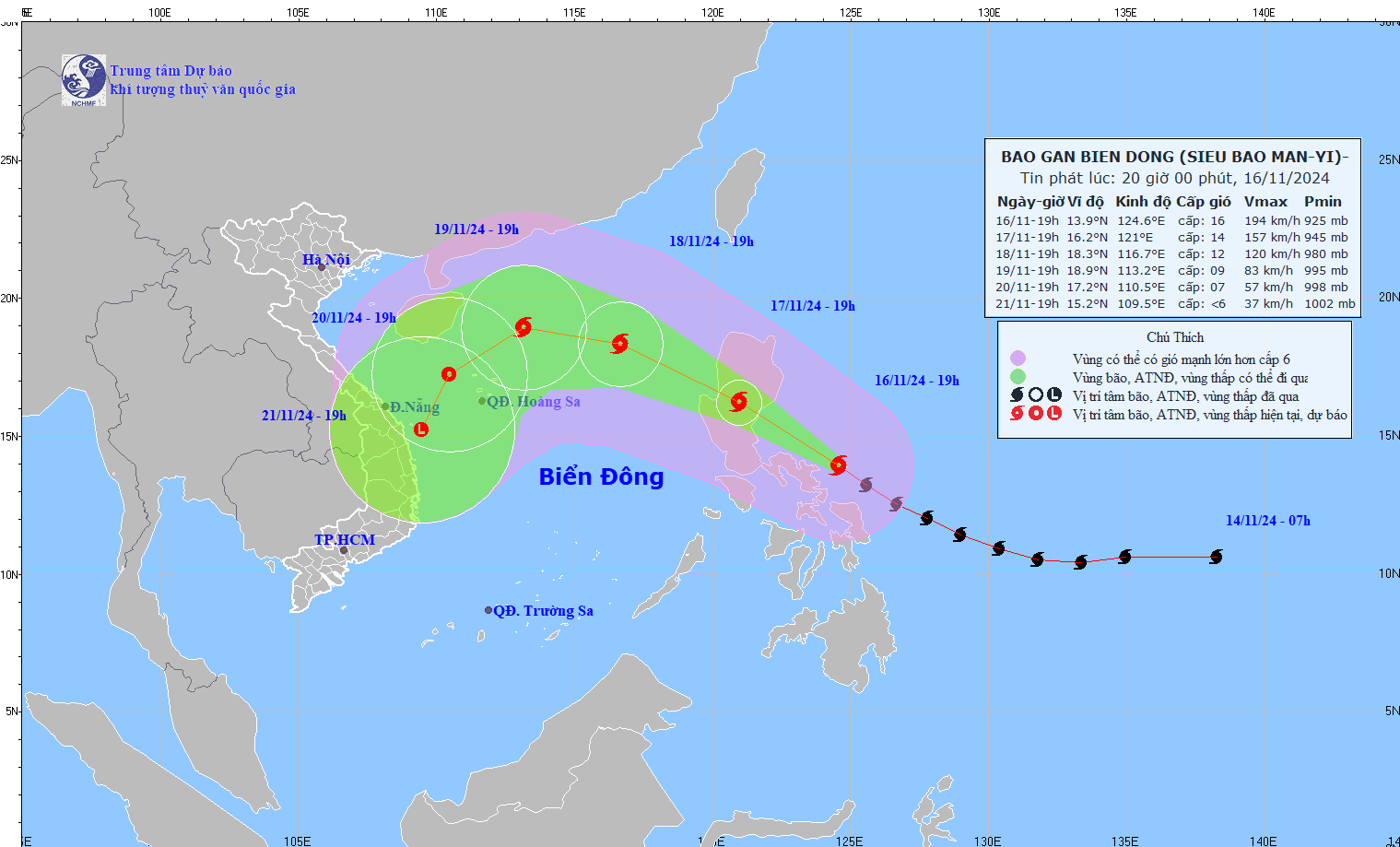
Over the next 24 to 72 hours, Super Typhoon Manyi will continue to move northwest, then shift west-northwest at a speed of 20-25 km/h, before slowing to 15 km/h. After making landfall on Luzon Island (Philippines), Typhoon Manyi will enter the South China Sea around November 18th, becoming the ninth typhoon to affect Vietnam during this year's typhoon season.
However, meteorological experts predict that after entering the South China Sea, Super Typhoon Man-yi will be weakened by about 3 levels by a cold air mass over the sea. By 7 PM on November 18th, Typhoon Man-yi was located in the eastern part of the North South China Sea, about 600km east-northeast of the Paracel Islands, moving northwest at a speed of 20-25km per hour before gradually weakening.
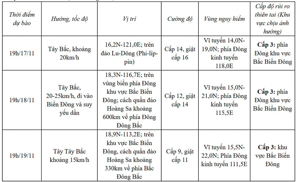
By 7 PM on November 19th, the storm was located in the northern South China Sea, approximately 330km north-northeast of the Hoang Sa archipelago, with wind speeds reduced to level 9, gusting to level 11.
Over the next 72 to 120 hours, the storm moved southwest at a speed of 10 km per hour, continuing to weaken in intensity.
According to Mr. Nguyen Van Huong, Head of the Weather Forecasting Department at the National Center for Hydro-Meteorological Forecasting, the interaction between the cold air mass and Typhoon Man-yi will cause significant changes in the intensity and direction of the typhoon's movement; the weather in the East Sea region in the coming days will be very bad, with strong winds, high waves, and volatility.
Specifically, from tomorrow afternoon (November 17th), the eastern sea area of the North East Sea will experience strong winds of force 6-7, later increasing to force 8-9, reaching force 10-12 near the storm's center, with gusts up to force 16; sea waves will be 2-4m high, and 5-7m near the storm's center; the sea will be extremely rough.
Warning: Vessels operating in the aforementioned hazardous areas are susceptible to thunderstorms, tornadoes, strong winds, and high waves.
The development of Typhoon Man-yi is still subject to change and requires close monitoring in subsequent news reports.
A cold front is approaching, bringing cold weather to Northern and North Central Vietnam.

Hanoi weather forecast for the next 3 days: Strong sunshine up to 33 degrees Celsius, cold air mass coming soon.
Two consecutive 'unusual' storms, Typhoon Man-yi (Category 15) likely to enter the South China Sea.
Source: https://vietnamnet.vn/sieu-bao-man-yi-huong-vao-bien-dong-kha-nang-gap-buc-tuong-khong-khi-lanh-2342717.html


![[Photo] Prime Minister Pham Minh Chinh attends the Conference on the Implementation of Tasks for 2026 of the Industry and Trade Sector](/_next/image?url=https%3A%2F%2Fvphoto.vietnam.vn%2Fthumb%2F1200x675%2Fvietnam%2Fresource%2FIMAGE%2F2025%2F12%2F19%2F1766159500458_ndo_br_shared31-jpg.webp&w=3840&q=75)


Comment (0)