
For a very long time, until before 2011, Ninh Thuan experienced virtually no flooding. Water wasn't stored in reservoirs, so after heavy rains, it would overflow freely, causing widespread flooding, but not major floods. The most devastating flood occurred in 1964. That year, after three consecutive storms, rain lasted from November 4th to 10th, 1964, pouring down on the entire central region. The heaviest rainfall in Ninh Thuan lasted throughout the night of November 6th and the day of November 7th, 1964, averaging 300mm, with the total rainfall reaching 800mm; higher than the province's average annual rainfall (700-800mm/year).
And, like many other areas along the southern coastal strip of Nam - Ngai - Binh - Phu - Khanh - Ninh, Ninh Thuan was submerged in a great flood. To reiterate, it was a flood, not a mere inundation.
Meanwhile, over the past two days, from 1 PM on November 16th to 1 PM on November 17th, heavy rain has fallen across Khanh Hoa province, with rainfall in many areas exceeding the peak of the historic flood of the Year of the Dragon. Specifically: Cam Phuoc Dong 392.7mm; Khanh Phu 274.2mm; Thanh Son (next to the northwest of Phan Rang - Thap Cham) 370.0mm.
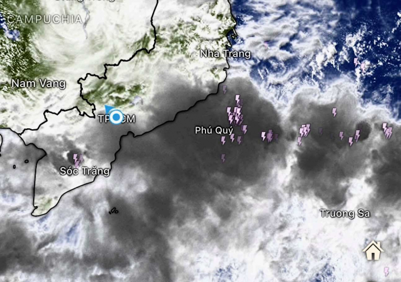
By the morning of November 17th, the rain had temporarily stopped. However, a low-pressure trough and a massive cloud mass are moving into southern Khanh Hoa (formerly Ninh Thuan) from the west-northwest, forecasting heavy to very heavy rain this afternoon and evening, possibly even exceeding the rain that fell throughout the day and night of November 16th and into the early morning of November 17th.
According to monitoring data at 6:00 AM on November 17th, the average fullness of the entire reservoir system in Ninh Thuan (formerly) reached 97.6% of its designed capacity; 17 out of 25 reservoirs were full or exceeded 100%. To ensure safety before the upcoming heavy rain, the Ninh Thuan reservoir system simultaneously opened its floodgates or allowed overflow. Song Cai Reservoir (the largest reservoir in the province, 270 million m³) reached a water level of 194.11m, exceeding the designed level by 1.31m, with 5 sluice gates open, discharging nearly 674 m³/s through the spillway. Tra Co, Phuoc Trung, Ba Rau, Nuoc Ngọt, and Ong Kinh reservoirs were all full, overflowing freely from 25-60cm, with discharge rates from 20 to over 100 m³/s. Nuoc Ngọt Reservoir in Vinh Hai commune overflowed freely by 256cm, with a discharge rate of 418.33 m³/s.
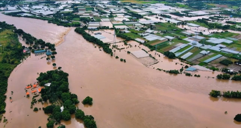
The water level of the Cai River (Dinh River) from Ninh Son down to Phan Rang is rising very rapidly. At the Tan My hydrological station, the Cai River in Phan Rang has peaked at 39.33m (at 11:00 AM on November 17th), 1.83m above alarm level 3. Floods are continuing to rise downstream. If there is more rain and the reservoirs release water, the Cai River will not be able to handle all the water, making a major flood unavoidable.
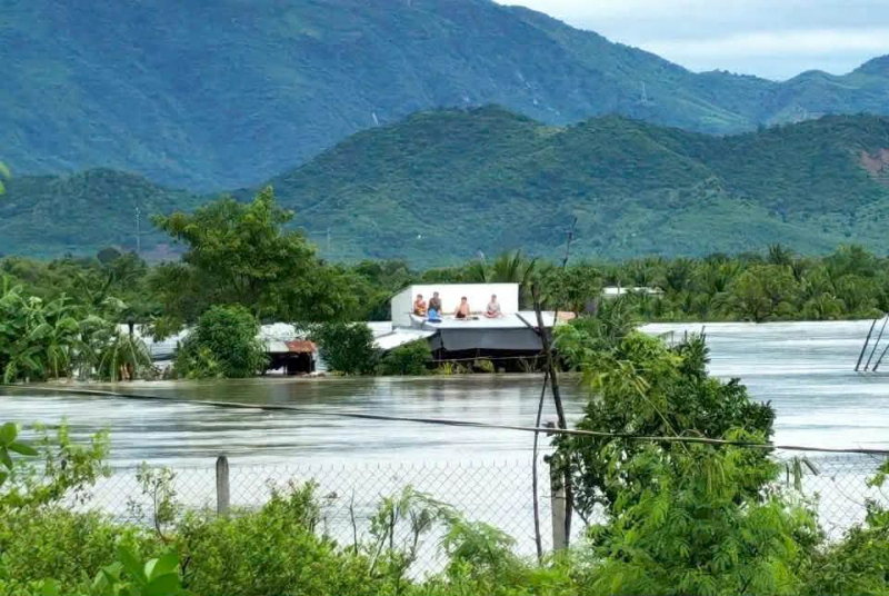
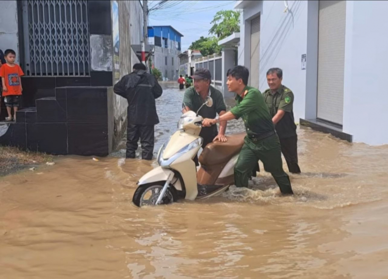
The video shows the Dinh River section passing under the Mong Bridge (railway bridge) near the Cham Tower at 2:30 PM, with water almost overflowing the bridge's pillars. In An Thanh, Vinh Hai, and Phan Rang, since 2 PM this afternoon, water has flooded some houses. In northern Phan Rang, since this morning, the Du Long industrial zone has been flooded by more than 1 meter. In the Ba Ngoi area of Cam Ranh, rescue boats have been able to operate on the paved roads, while in some places, people have had to climb onto their roofs since 2 PM, waiting for the rain to fall this evening. Northern Ninh Thuan will not be able to "share water" with the Phan Rang and southern areas.


Therefore, it is almost certain that with more heavy rain tonight, the former Ninh Thuan province and many areas of the former Khanh Hoa province will experience flooding. The water level may not be as high as the flood of 1964, but the level of danger is difficult to predict, as this is a flood that causes flooding.
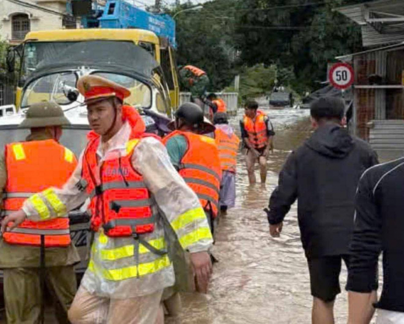
Currently, local authorities are urgently and vigorously working to prevent flooding. Those from Ninh Thuan and Khanh Hoa provinces who live far away will likely stay awake all night watching over their families.
Hopefully, the reality will be milder than what has been predicted and anticipated.
On Zalo, the Phan Rang Ward Police fanpage posted the message: "The safety and peace of the people are paramount. In all difficult situations, the Phan Rang Ward Police and local forces are always ready to be an extended arm, a solid support for people to feel secure in preventing and mitigating natural disasters."
Please contact Phan Rang Ward Police Station immediately if you need assistance or report an incident: 02593.822.563
Source: https://cand.com.vn/doi-song/song-dinh-phan-rang-co-nguy-co-tran-bo-gay-lu-lon-i788343/

![[Photo] Secretary of the National Assembly Party Committee, Chairman of the National Assembly presides over the meeting of the Standing Committee and Executive Committee of the National Assembly Party Committee.](https://vphoto.vietnam.vn/thumb/1200x675/vietnam/resource/IMAGE/2026/06/03/1780480353201_ndo_br_bnd-2585-jpg.webp)

![[Photo] First session of the 14th Congress of the Vietnam Trade Union](https://vphoto.vietnam.vn/thumb/1200x675/vietnam/resource/IMAGE/2026/06/03/1780465947883_ndo_br_img-3852-jpg.webp)

![[Photo] General Secretary and President To Lam presides over a meeting with the Central Organizing Committee.](https://vphoto.vietnam.vn/thumb/1200x675/vietnam/resource/IMAGE/2026/06/03/1780482764658_a1-bnd-4741-3342-jpg.webp)


![[Video] Sunset at Lap An Lagoon – Where the sun sets over the fishing nets](https://vphoto.vietnam.vn/thumb/1200x675/vietnam/resource/IMAGE/2026/05/31/1780192137701_beach-landscape-sea-water-nature-grass-745871-pxhere-com.jpeg)


Comment (0)